Le Palais
| Le Palais Porzh-Lae | ||
|---|---|---|
|
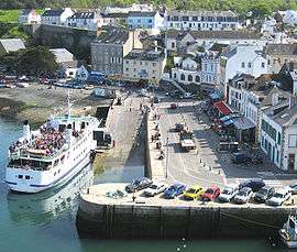
Ferry in the harbour | ||
| ||
 Le Palais | ||
|
Location within Brittany region  Le Palais | ||
| Coordinates: 47°20′50″N 3°09′15″W / 47.3472°N 3.1542°WCoordinates: 47°20′50″N 3°09′15″W / 47.3472°N 3.1542°W | ||
| Country | France | |
| Region | Brittany | |
| Department | Morbihan | |
| Arrondissement | Lorient | |
| Canton | Belle-Île | |
| Intercommunality | Belle-Île-en-Mer | |
| Government | ||
| • Mayor (2008—2014) | Frédéric Le Gars | |
| Area1 | 17.43 km2 (6.73 sq mi) | |
| Population (1999)2 | 2,457 | |
| • Density | 140/km2 (370/sq mi) | |
| Time zone | CET (UTC+1) | |
| • Summer (DST) | CEST (UTC+2) | |
| INSEE/Postal code | 56152 / 56360 | |
| Elevation | 0–58 m (0–190 ft) | |
|
1 French Land Register data, which excludes lakes, ponds, glaciers > 1 km² (0.386 sq mi or 247 acres) and river estuaries. 2 Population without double counting: residents of multiple communes (e.g., students and military personnel) only counted once. | ||
Le Palais (Breton: Porzh-Lae) is a commune in the Morbihan department of Brittany in northwestern France.
It is one of the four communes on the island Belle Île.
Demographics
Inhabitants of Le Palais are called in French Palantins.
See also
References
External links
| Wikimedia Commons has media related to Le Palais. |
- French Ministry of Culture list for Le Palais (French)
- Map of Le Palais on Michelin (English)
This article is issued from Wikipedia - version of the 2/13/2015. The text is available under the Creative Commons Attribution/Share Alike but additional terms may apply for the media files.