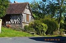
Les Autels-Saint-Bazile
| Les Autels-Saint-Bazile | |
|---|---|
 | |
 Les Autels-Saint-Bazile | |
|
Location within Normandy region  Les Autels-Saint-Bazile | |
| Coordinates: 48°56′29″N 0°05′02″E / 48.9414°N 0.0839°ECoordinates: 48°56′29″N 0°05′02″E / 48.9414°N 0.0839°E | |
| Country | France |
| Region | Normandy |
| Department | Calvados |
| Arrondissement | Lisieux |
| Canton | Livarot |
| Intercommunality | Pays de Livarot |
| Government | |
| • Mayor (2008–2020) | Xavier Lemarchand |
| Area1 | 5.53 km2 (2.14 sq mi) |
| Population (2010)2 | 48 |
| • Density | 8.7/km2 (22/sq mi) |
| Time zone | CET (UTC+1) |
| • Summer (DST) | CEST (UTC+2) |
| INSEE/Postal code | 14029 / 14140 |
| Elevation | 81–226 m (266–741 ft) |
|
1 French Land Register data, which excludes lakes, ponds, glaciers > 1 km² (0.386 sq mi or 247 acres) and river estuaries. 2 Population without double counting: residents of multiple communes (e.g., students and military personnel) only counted once. | |
Les Autels-Saint-Bazile is a former commune in the Calvados department in the Normandy region of north-western France. On 1 January 2016, it was merged into the new commune of Livarot-Pays-d'Auge.[1]
Geography
Les Autels-Saint-Bazile is located some 45 km south-east of Caen and 28 km south-west of Lisieux. The eastern and southern border of the commune is the departmental border between Calvados and Orne. Access to the commune is by the D38 road from Heurtevent in the north which forms part of the northern border before crossing the commune and passing through the village continuing to the south. The D155 comes from the north and passes down the north-eastern side of the commune before continuing south to Le Renouard. The D38A goes east from the village to connect with the D155. The D111 also passes south through the western extension of the commune. The commune is mixed forest and farmland.[2]
The Monne river forms the eastern border of the commune as it flows north-east to join the Vie north of La Brévière. An unnamed stream rises in the centre of the commune and flows east to join the Monne. The Aubette forms the western border of the western extension of the commune. The Ruisseau de Clermont rises in the west of the commune and flows north to join the Aubette.[2]
Neighbouring communes and villages[2]
 |
Notre-Dame-de-Fresnay | Tortisambert | La Chapelle-Haute-Grue | |
| Ammeville | |
Saint-Germain-de-Montgommery | ||
| ||||
| | ||||
| Le Renouard | Crouttes |
Administration
List of Successive Mayors[3]
| From | To | Name | Party | Position |
|---|---|---|---|---|
| 1922 | 1924 | Firmin Lemarchand | ||
| 1959 | 2001 | Bernard Lemarchand | ||
| 2001 | 2020 | Xavier Lemarchand |
(Not all data is known)
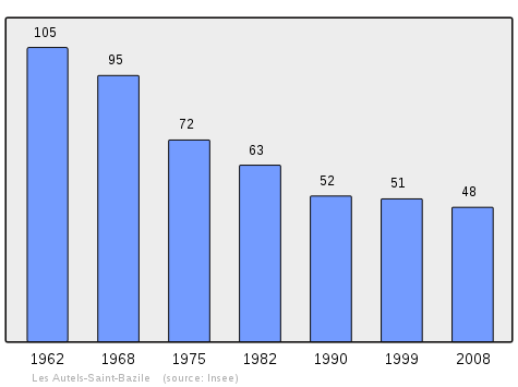
Demography
In 2010 the commune had 48 inhabitants. The evolution of the number of inhabitants is known from the population censuses conducted in the commune since 1793. From the 21st century, a census of communes with fewer than 10,000 inhabitants is held every five years, unlike larger communes that have a sample survey every year.[Note 1]
| 1793 | 1800 | 1806 | 1821 | 1831 | 1836 | 1841 | 1846 | 1851 |
|---|---|---|---|---|---|---|---|---|
| 75 | 59 | 70 | 81 | 86 | 178 | 188 | 184 | 171 |
| 1856 | 1861 | 1866 | 1872 | 1876 | 1881 | 1886 | 1891 | 1896 |
|---|---|---|---|---|---|---|---|---|
| 155 | 164 | 165 | 151 | 179 | 170 | 173 | 161 | 144 |
| 1901 | 1906 | 1911 | 1921 | 1926 | 1931 | 1936 | 1946 | 1954 |
|---|---|---|---|---|---|---|---|---|
| 157 | 140 | 139 | 119 | 118 | 124 | 113 | 142 | 113 |
| 1962 | 1968 | 1975 | 1982 | 1990 | 1999 | 2006 | 2010 | - |
|---|---|---|---|---|---|---|---|---|
| 105 | 95 | 72 | 63 | 52 | 51 | 45 | 48 | - |
Sources : Ldh/EHESS/Cassini until 1962, INSEE database from 1968 (population without double counting and municipal population from 2006)

Culture and heritage
Religious heritage
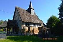
The Parish Church of Saint Basile contains two items that are registered as historical objects:
- A Consecrated water bowl with water-sprinkler (17th century)
 [4]
[4] - A Statue: Virgin and child (15th century)[5]
See also
External links
- Les Autels-Saint-Bazile on Lion1906
- Les Authels and St. Bazile on the 1750 Cassini Map
- Les Autels-Saint-Bazile on the INSEE website (French)
Notes and references
Notes
- ↑ At the beginning of the 21st century, the methods of identification have been modified by Law No. 2002-276 of 27 February 2002, the so-called "law of local democracy" and in particular Title V "census operations" allows, after a transitional period running from 2004 to 2008, the annual publication of the legal population of the different French administrative districts. For communes with a population greater than 10,000 inhabitants, a sample survey is conducted annually, the entire territory of these communes is taken into account at the end of the period of five years. The first "legal population" after 1999 under this new law came into force on 1 January 2009 and was based on the census of 2006.
References
- ↑ Arrêté préfectoral 24 December 2015 (French)
- 1 2 3 Google Maps
- ↑ List of Mayors of France (French)
- ↑ Ministry of Culture, Palissy PM14001177 Consecrated water bowl with water-sprinkler
(French)

- ↑ Ministry of Culture, Palissy PM14001127 Statue: Virgin and child
(French)
| Wikimedia Commons has media related to Les Autels-Saint-Bazile. |