Les Lacs-du-Témiscamingue, Quebec
| Les Lacs-du-Témiscamingue | |
|---|---|
| Unorganized territory | |
|
Lacs-du-Témiscamingue as seen across the Ottawa River near Mattawa | |
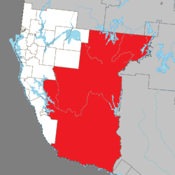 Location within Témiscamingue RCM. | |
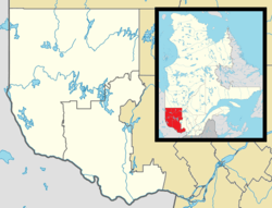 Les Lacs-du-Témiscamingue Location in western Quebec. | |
| Coordinates: 47°04′N 78°26′W / 47.067°N 78.433°WCoordinates: 47°04′N 78°26′W / 47.067°N 78.433°W[1] | |
| Country |
|
| Province |
|
| Region | Abitibi-Témiscamingue |
| RCM | Témiscamingue |
| Constituted | October 31, 2005 |
| Government[2] | |
| • Federal riding | Abitibi—Témiscamingue |
| • Prov. riding | Rouyn-Noranda–Témiscamingue |
| Area[2][3] | |
| • Total | 12,179.30 km2 (4,702.45 sq mi) |
| • Land | 10,418.12 km2 (4,022.46 sq mi) |
| Population (2011)[3] | |
| • Total | 0 |
| • Density | 0.0/km2 (0/sq mi) |
| • Pop (2006–11) |
|
| • Dwellings | 25 |
| Time zone | EST (UTC−5) |
| • Summer (DST) | EDT (UTC−4) |

Les Lacs-du-Témiscamingue (French meaning "The Lakes of Temiscaming") is a vast unorganized territory in the Abitibi-Témiscamingue region of Quebec, Canada. With a surface area of 10,410 square kilometres (4,020 sq mi), it takes up over 60% of the eastern portion of the Témiscamingue Regional County Municipality.
Until October 31, 2005, Les Lacs-du-Témiscamingue and Laniel unorganized territories were part of the Rivière-Kipawa unorganized territory.[4]
Demographics
Population:
- Population in 2006: 0
- Population in 2006: 5
- Population in 2001: 0 (adjusted for boundary change)
Private dwellings occupied by usual residents: 1
Total private dwellings: 25
See also
References
- ↑ Reference number 390267 of the Commission de toponymie du Québec (French)
- 1 2 Ministère des Affaires municipales, des Régions et de l'Occupation du territoire - Répertoire des municipalités: Les Lacs-du-Témiscamingue
- 1 2 Statistics Canada 2011 Census - Les Lacs-du-Témiscamingue census profile
- ↑ http://www.stat.gouv.qc.ca/publications/referenc/pdf2005/Modif_oct05.pdf
 |
Rouyn-Noranda, Val-d'Or | Lac-Granet | | |
| Laforce, Belleterre, Béarn, Laniel, Témiscaming, Kipawa, Kebaowek | |
Réservoir-Dozois, Lac-Nilgaut | ||
| ||||
| | ||||
| Ottawa River / Mattawan |
Ottawa River / Mattawa / Papineau-Cameron / Head, Clara and Maria |
Rapides-des-Joachims |
| Cities | |
|---|---|
| Municipalities | |
| Townships |
|
| Parishes | |
| Villages | |
| Unorganized territories | |
| |
This article is issued from Wikipedia - version of the 2/23/2014. The text is available under the Creative Commons Attribution/Share Alike but additional terms may apply for the media files.