Leverett, Mississippi
| Leverett, Mississippi | |
|---|---|
| Unincorporated community | |
 Leverett, Mississippi  Leverett, Mississippi | |
| Coordinates: 33°52′58″N 90°04′32″W / 33.88278°N 90.07556°WCoordinates: 33°52′58″N 90°04′32″W / 33.88278°N 90.07556°W | |
| Country | United States |
| State | Mississippi |
| County | Tallahatchie |
| Elevation | 154 ft (47 m) |
| Time zone | Central (CST) (UTC-6) |
| • Summer (DST) | CDT (UTC-5) |
| ZIP code | 38920 |
| Area code(s) | 662 |
| GNIS feature ID | 672412[1] |
Leverett is an unincorporated community located in Tallahatchie County, Mississippi, United States. Leverett is approximately 3.5 miles (5.6 km) south of Paynes, 7.4 miles (11.9 km) southeast of Tippo and 5.4 miles (8.7 km) northwest of Cascilla.
Leverett is located on Leverett Lane near Mississippi Highway 35.
Leverett has a ZIP code of 38920.
References
Municipalities and communities of Tallahatchie County, Mississippi, United States | ||
|---|---|---|
| City | 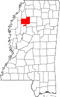 | |
| Towns | ||
| Village | ||
| Unincorporated communities | ||
| Ghost towns | ||
| Footnotes | ‡This populated place also has portions in an adjacent county or counties | |
This article is issued from Wikipedia - version of the 7/30/2016. The text is available under the Creative Commons Attribution/Share Alike but additional terms may apply for the media files.