Lingadipa
| Lingadipa | |
|---|---|
| Village | |
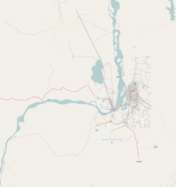 Lingadipa Location in the Sagaing area and in relation to the Irrawaddy River. | |
| Coordinates: 21°54′11″N 95°30′19″E / 21.90306°N 95.50528°ECoordinates: 21°54′11″N 95°30′19″E / 21.90306°N 95.50528°E | |
| Country |
|
| Region | Sagaing Region |
| District | Sagaing District |
| Township | Myinmu Township |
| Time zone | MST (UTC+6.30) |
Lingadipa is a village in Myinmu Township in the southeast of the Sagaing Division in Burma. It is located west of Myinmu, near Allagappa on the northern bank of the Irrawaddy River. The village was occupied by the British Indian Army on 13–14 February 1944 during World War II.[1]
References
- ↑ Marston, Daniel (2003). Phoenix from the ashes: the Indian Army in the Burma Campaign. Greenwood Publishing Group. p. 187. ISBN 0-275-98003-0.
External links
Capital: Sagaing | ||
| Hkamti District |  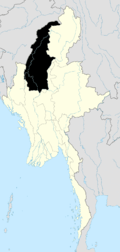 | |
| Kale District | ||
| Katha District | ||
| Mawlaik District | ||
| Monywa District | ||
| Sagaing District | ||
| Shwebo District | ||
| Tamu District | ||
| Yinmabin District | ||
| Naga Self-Administered Zone | ||
This article is issued from Wikipedia - version of the 11/6/2016. The text is available under the Creative Commons Attribution/Share Alike but additional terms may apply for the media files.