Linslaw, Oregon
| Linslaw, Oregon | |
|---|---|
| Unincorporated community | |
 Linslaw, Oregon  Linslaw, Oregon | |
| Coordinates: 44°00′00″N 123°41′02″W / 44°N 123.684°WCoordinates: 44°00′00″N 123°41′02″W / 44°N 123.684°W | |
| Country | United States |
| State | Oregon |
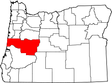
| County | Lane |
| Elevation | 305 ft (93 m) |
| Time zone | Pacific (PST) (UTC-8) |
| • Summer (DST) | PDT (UTC-7) |
| ZIP code | 97490 |
| Area code(s) | 458 and 541 |
Linslaw is an unincorporated community in Lane County, Oregon, United States.[1] It is located about eight miles west of Walton on Oregon Route 126 next to the Siuslaw River.[2]
In 1917, when a petition was sent to the United States Post Office Department for a post office at this locale, it was approved with the name "Linslaw".[3][4] Locals could not explain the source of the name, but the author of Oregon Geographic Names has a theory that the name was supposed to be "Siuslaw", and the handwriting on the petition was unclear and misread as "Linslaw".[3] Linslaw post office was closed in 1957.[3][5] The Coos Bay Line of the Southern Pacific Railroad had a station here.[3] Today this line is owned by the Central Oregon and Pacific Railroad.
References
- ↑ "Linslaw". Geographic Names Information System. United States Geological Survey. November 28, 1980. Retrieved 2010-12-21.
- ↑ Oregon Atlas & Gazetteer (7th ed.). Yarmouth, Maine: DeLorme. 2008. p. 38. ISBN 0-89933-347-8.
- 1 2 3 4 McArthur, Lewis A.; McArthur, Lewis L. (2003) [1928]. Oregon Geographic Names (7th ed.). Portland, Oregon: Oregon Historical Society Press. p. 581. ISBN 978-0875952772.
- ↑ "Names of Lane County Communities Reveal Interesting Histories, Anecdotes". Eugene Register-Guard. 4 January 1942. p. 4. Retrieved 23 April 2015.
- ↑ "Lane County". Jim Forte Postal History. Retrieved 23 April 2015.
This article is issued from Wikipedia - version of the 7/31/2016. The text is available under the Creative Commons Attribution/Share Alike but additional terms may apply for the media files.