List of airports in the Philippines
This is a list of airports in the Philippines, grouped by type and sorted by the airport's general location name.
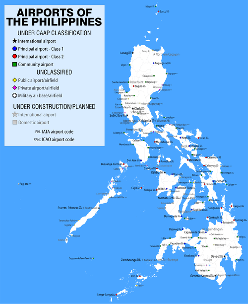
Three classes of airports exist in the Philippines under the new system of classification instituted by the Civil Aviation Authority of the Philippines (CAAP): international airports, principal airports and community airports. Only airports owned by the national government are classified by the CAAP; the vast majority of minor aerodromes around the country are not owned by the national government and remain unclassified under the new scheme.
Classification
Airports in the Philippines have used two different types of classification: one previously by the Air Transportation Office (ATO) and another being used by the Civil Aviation Authority of the Philippines (CAAP), the successor body to the ATO.
ATO system
The old ATO system divided airports into five classifications under two broad categories: international and domestic airports. These two broad categories were further divided into the following airport types:
- Primary international airports are the primary international gateways into the Philippines.
- Secondary international airports are airports that are capable of handling international flights but are not designated as primary international gateways. These airports may or may not service actual international flights and may or may not have active customs and immigration facilities.
- Trunkline airports or major commercial domestic airports are domestic airports in major cities around the Philippines that are capable of supporting large aircraft. These are, in most cases, the only domestic airports with an instrument landing system.
- Secondary airports or minor commercial domestic airports are domestic airports in smaller cities and municipalities usually capable of handling smaller propeller aircraft. Some airports in this classification are capable of supporting jet aircraft. However, these airports are only open from sunrise until sunset, usually requiring notification of airport authorities if nighttime landing is a necessity.
- Feeder airports are domestic airports capable only of handling small propeller aircraft. Many of these airports are small airstrips serving far-flung islands.
CAAP system
The new CAAP system revises the previous ATO system, while maintaining the current classification of airports into international and domestic airports.[1] The change was made pursuant to the Philippine Transport Strategic Study and the 1992 Civil Aviation Master Plan. The new system rationalizes the system of airport classification, represented by the following types:
- International airports are airports capable of handling international flights. Airports in this category include airports that currently have or have previously served international destinations. There are currently thirteen airports in this category, including all primary international airports, most secondary international airports and Puerto Princesa Airport and Kalibo Airport, both trunkline and secondary airports, respectively.
- Principal airports or domestic airports are airports that only serve domestic destinations. There are two types:
- Class 1 principal airports are airports capable of serving jet aircraft with a capacity of at least 100 seats.[1] Most airports previously classified as trunkline airports, as well as some secondary airports, are placed in this category. Dumaguete Airport falls in this category.
- Class 2 principal airports are airports capable of serving propeller aircraft with a capacity of at least 19 seats.[1] Loakan Airport in Baguio City, previously a trunkline airport, some secondary airports, and Godofredo P. Ramos Airport in Malay, Aklan; Camiguin Airport, Cuyo Airport and Sayak Airport in Del Carmen, Surigao del Norte (on Siargao Island), all feeder airports, are in this category.
- Community airports are airports that are used primarily for general aviation.[1] Most feeder airports are in this category and only three airports: Cauayan Airport, Labo Airport in Ozamiz and San Fernando Airport in La Union, all former secondary airports, have regular air service.
Some feeder airports previously classified in the old ATO system, such as Lucena Airport, are not covered by the new system. Airports not owned by the national government which were not classified in the previous ATO system, such as El Nido Airport, remain unclassified under the present CAAP system.
Airports
Airport names in bold have scheduled service on commercial airlines.
NOTE on ICAO codes: Under the current ICAO code assignment scheme, airports in the Luzon island group (including the Cuyo Islands, but excluding Masbate, Romblon and the rest of Palawan) are assigned RPL- and RPU- codes; those in the Visayas, Masbate, Romblon and Palawan (except for Cuyo), RPV- and RPS-; and those in Mindanao, RPM- and RPN-. ICAO airport codes with numbers (RP12 thru 17) are temporary; those in italic (RPEN, RPPN, RPTP) may be obsolete or unofficial as they do not fit the current code assignment scheme.
CAAP-classified airports
The lists below follow the CAAP's classification for airports in the Philippines.[2]
International Airports
Principal Domestic Airports
Community Airports
- ^ Cities that have become independent of the province are listed with the province it was formerly part of, as is the practice for statistical purposes.
Unclassified aerodromes
Being not owned by the national government and therefore falling outside of the CAAP's responsibility, the various aerodromes listed in this section remain unclassified under the new scheme. These airports, airfields or airstrips are privately owned by individuals, corporations, local governments and/or other civilian entities. Some may be non-operational, abandoned, inactive or already closed. Most can only handle small aircraft, but a few can take some amount of chartered or regularly scheduled cargo and/or commercial air traffic.[3]
| City/Municipality | Province | IATA | ICAO | Airport name | Primary related industry | Coordinates |
|---|---|---|---|---|---|---|
| Candelaria | Zambales | Acoje Airstrip | Mining (now defunct) | 15°41′24″N 120°03′09″E / 15.69000°N 120.05250°E | ||
| Tarlac City | Tarlac | Alto Airfield | General aviation | 15°25′30″N 120°37′50″E / 15.42500°N 120.63056°E | ||
| Aroroy | Masbate | Amoroy Airstrip | Mining | 12°30′08″N 123°22′29″E / 12.50222°N 123.37472°E | ||
| Aparri | Cagayan | RPUA | Aparri (Maura) Airport | Tourism/general aviation | 18°21′17″N 121°39′12″E / 18.35472°N 121.65333°E | |
| Mercedes (Apuao Grande Island) | Camarines Norte | Apuao Grande Airstrip | Tourism/general aviation | 14°05′06″N 123°05′31″E / 14.08500°N 123.09194°E | ||
| Aborlan | Palawan | Apurawan Airstrip | Tourism/general aviation | 09°35′51″N 118°20′18″E / 9.59750°N 118.33833°E | ||
| Cagwait | Surigao del Sur | Aras-Asan Airstrip | Forestry | 08°54′27″N 126°18′01″E / 8.90750°N 126.30028°E | ||
| Asturias | Cebu | Asturias Airstrip | Agriculture | 10°32′29″N 123°44′42″E / 10.54139°N 123.74500°E | ||
| San Fernando (Sibuyan Island) | Romblon | Azagra Airstrip | Tourism/general aviation | 12°16′24″N 122°37′42″E / 12.27333°N 122.62833°E | ||
| Hinoba-an | Negros Occidental | Bacuyangan Airstrip | Forestry | 09°38′01″N 122°27′34″E / 9.63361°N 122.45944°E | ||
| Placer | Surigao del Norte | Bad-as Airfield | General aviation (defunct) | 09°37′59″N 125°33′23″E / 9.63306°N 125.55639°E | ||
| Baganga | Davao Oriental | BNQ | Baganga (Lambajon) Airport | Forestry | 07°36′44″N 126°34′07″E / 7.61222°N 126.56861°E | |
| Balabagan | Lanao del Sur | Balabagan Airstrip | Agriculture | 07°30′49″N 124°07′17″E / 7.51361°N 124.12139°E | ||
| Polillo (Balesin Island) | Quezon | Balesin (Tordesillas) Airport | Tourism/general aviation | 14°25′07″N 122°02′21″E / 14.41861°N 122.03917°E | ||
| Aparri (Barit Island) | Cagayan | Barit Airstrip | Tourism/general aviation | 18°52′11″N 121°15′23″E / 18.86972°N 121.25639°E | ||
| Dasol | Pangasinan | Barlo Airstrip | Mining | 15°59′37″N 119°55′19″E / 15.99361°N 119.92194°E | ||
| Tanauan | Batangas | Barradas Airfield | General aviation | 14°05′49″N 121°06′58″E / 14.09694°N 121.11611°E | ||
| Basay | Negros Oriental | Basay Airstrip | Mining | 09°28′16″N 122°39′55″E / 9.47111°N 122.66528°E | ||
| Laoang (Batag Island) | Northern Samar | Batag Airstrip | General aviation (now defunct) | 12°37′00″N 125°03′04″E / 12.61667°N 125.05111°E | ||
| Taytay | Palawan | Bato Airstrip | General aviation | 10°42′22″N 119°29′18″E / 10.70611°N 119.48833°E | ||
| Quezon | Palawan | Berong Airstrip | Mining | 09°28′38″N 118°12′37″E / 9.47722°N 118.21028°E | ||
| Ilagan | Isabela | Bicobian Airstrip | Forestry | 17°16′17″N 122°25′45″E / 17.27139°N 122.42917°E | ||
| Binalonan | Pangasinan | Binalonan Airport | Agriculture | 16°03′01″N 120°34′56″E / 16.05028°N 120.58222°E | ||
| Brooke's Point | Palawan | Brooke's Point Airstrip | Tourism/general aviation | 08°48′26″N 117°50′58″E / 8.80722°N 117.84944°E | ||
| Buenavista | Agusan del Norte | RPWV | Buenavista Airfield | General aviation (now defunct) | 08°56′17″N 125°23′28″E / 8.93806°N 125.39111°E | |
| Balabac (Bugsuk Island) | Palawan | Bugsuk (Bonbon) Airport | Agriculture | 08°13′29″N 117°19′25″E / 8.22472°N 117.32361°E | ||
| Mabalacat | Pampanga | Bundagul Airstrip | Heavy industry | 15°14′26″N 120°35′56″E / 15.24056°N 120.59889°E | ||
| Mangatarem | Pangasinan | Cabaluyan Airstrip | Agriculture | 15°41′24″N 120°19′49″E / 15.69000°N 120.33028°E | ||
| Lal-lo | Cagayan | Cagayan North International Airport | Tourism/Industry/Logistics | 18°10′55″N 121°44′45″E / 18.18194°N 121.74583°E | ||
| Cagayancillo | Palawan | Cagayancillo Airstrip | Tourism/general aviation | 09°34′10″N 121°11′11″E / 9.56944°N 121.18639°E | ||
| Aroroy | Masbate | Calanay Airstrip | Agriculture | 12°27′44″N 123°17′02″E / 12.46222°N 123.28389°E | ||
| Calatagan | Batangas | Calatagan (Hacienda Zobel) Airstrip | Agriculture/general aviation | 13°50′36″N 120°38′01″E / 13.84333°N 120.63361°E | ||
| San Francisco (Pacijan Island) | Cebu | Camotes Airstrip | Tourism/general aviation | 10°39′22″N 124°22′14″E / 10.65611°N 124.37056°E | ||
| Balabac (Candaraman Island) | Palawan | Candaraman Airstrip | Tourism/general aviation | 08°04′35″N 117°06′30″E / 8.07639°N 117.10833°E | ||
| Santa Catalina | Negros Oriental | Caranoche Airstrip | Agriculture | 09°21′07″N 122°50′53″E / 9.35194°N 122.84806°E | ||
| Carranglan | Nueva Ecija | Carranglan Airstrip | General aviation (now defunct) | 15°58′53″N 121°02′23″E / 15.98139°N 121.03972°E | ||
| Casiguran | Aurora | CGG | Casiguran Airport | Forestry | 16°11′38″N 122°03′48″E / 16.19389°N 122.06333°E | |
| Taytay | Palawan | RZP | RPSD | Cesar Lim Rodriguez (Taytay-Sandoval) Airport | Tourism/general aviation | 11°03′06″N 119°31′06″E / 11.05167°N 119.51833°E |
| New Bataan | Compostela Valley | Cogonan Airstrip | Agriculture | 07°35′21″N 126°06′38″E / 7.58917°N 126.11056°E | ||
| New Bataan | Compostela Valley | Consuelo Airstrip 1 | Agriculture | 07°38′36″N 126°05′40″E / 7.64333°N 126.09444°E | ||
| New Bataan | Compostela Valley | Consuelo Airstrip 2 | Agriculture | 07°38′00″N 126°05′19″E / 7.63333°N 126.08861°E | ||
| Coron (Busuanga Island) | Palawan | XCN | Coron Rural Airport | Tourism/general aviation | 12°00′42″N 120°12′02″E / 12.01167°N 120.20056°E | |
| Culion | Palawan | CUJ | Culion Airstrip | Tourism/general aviation | 11°51′16″N 119°56′15″E / 11.85444°N 119.93750°E | |
| Davao City | Davao del Sur | Dacudao Airstrip | Agriculture | 07°13′43″N 125°27′26″E / 7.22861°N 125.45722°E | ||
| Dalaguete | Cebu | Dalaguete (Casay) Airstrip | Tourism/general aviation | 09°49′18″N 123°32′53″E / 9.82167°N 123.54806°E | ||
| San Antonio (Dalupiri Island) | Northern Samar | San Antonio (Dalupiri) Airport | General Aviation | 12°25′04″N 124°16′26″E / 12.41778°N 124.27389°E | ||
| Panabo | Davao del Norte | Dapco Airstrip | Agriculture | 07°22′48″N 125°35′15″E / 7.38000°N 125.58750°E | ||
| Datu Paglas | Maguindanao | Datu Paglas Airstrip | Agriculture | 06°45′26″N 124°51′08″E / 6.75722°N 124.85222°E | ||
| Manolo Fortich | Bukidnon | RPMT | Del Monte Plantation Airstrip | Agriculture | 08°20′52″N 124°51′01″E / 8.34778°N 124.85028°E | |
| Roxas | Palawan | RPVL | Del Pilar Airport | Tourism/general aviation | 10°20′07″N 119°21′16″E / 10.33528°N 119.35444°E | |
| Kapalong | Davao del Norte | Delta Airstrip | Agriculture | 07°38′22″N 125°41′29″E / 7.63944°N 125.69139°E | ||
| Lianga | Surigao del Sur | Diatagon Airstrip | Forestry (now defunct) | 08°39′51″N 126°08′06″E / 8.66417°N 126.13500°E | ||
| Buluan | Maguindanao | Digal Airstrip | Agriculture | 06°44′17″N 124°49′36″E / 6.73806°N 124.82667°E | ||
| Dilasag | Aurora | DSG | Dilasag Airstrip | Forestry | 08°39′51″N 126°08′06″E / 8.66417°N 126.13500°E | |
| Dinapigue | Isabela | Dinapigue Airstrip | Forestry | 16°31′19″N 122°15′54″E / 16.52194°N 122.26500°E | ||
| Divilacan | Isabela | Divilacan Airstrip | Forestry | 17°19′58″N 122°17′58″E / 17.33278°N 122.29944°E | ||
| Mawab | Compostela Valley | Dizon Airstrip | Agriculture | 07°29′16″N 125°56′15″E / 7.48778°N 125.93750°E | ||
| Dolores | Eastern Samar | RPVX | Dolores (Picardo) Airport | Tourism/general aviation | 12°02′16″N 125°29′25″E / 12.03778°N 125.49028°E | |
| San Luis | Agusan del Sur | Doña Flavia Airstrip | Forestry | 08°28′06″N 125°42′38″E / 8.46833°N 125.71056°E | ||
| Tubay | Agusan del Norte | Doña Rosario (Tubay) Airstrip | Agriculture | 09°10′10″N 125°33′37″E / 9.16944°N 125.56028°E | ||
| El Nido | Palawan | ENI | RPEN | El Nido (Lio) Airport | Tourism/general aviation | 11°12′08″N 119°24′59″E / 11.20222°N 119.41639°E |
| Panabo | Davao del Norte | Evergreen Farms Airstrip | Agriculture | 07°18′22″N 125°39′28″E / 7.30611°N 125.65778°E | ||
| Santo Tomas | Davao del Norte | Farmington Airstrip | Agriculture | 07°28′06″N 125°38′10″E / 7.46833°N 125.63611°E | ||
| Aparri (Fuga Island) | Cagayan | Fuga Airstrip | Tourism/general aviation | 18°51′46″N 121°17′01″E / 18.86278°N 121.28361°E | ||
| Sablayan | Occidental Mindoro | General Emilio Aguinaldo (Sablayan) Airstrip | Agriculture/general aviation | 12°49′03″N 120°52′53″E / 12.81750°N 120.88139°E | ||
| Davao City | Davao del Sur | Guianga Airstrip | Agriculture | 07°05′46″N 125°23′23″E / 7.09611°N 125.38972°E | ||
| Hagonoy | Davao del Sur | Guihing Airstrip | Agriculture | 06°41′41″N 125°21′39″E / 6.69472°N 125.36083°E | ||
| Buenavista | Guimaras | Guimaras Airfield | Tourism/general aviation | 10°41′40″N 122°39′56″E / 10.69444°N 122.66556°E | ||
| Santa Cruz (Hermana Mayor Island) | Zambales | Hermana Mayor Airstrip | Tourism/general aviation | 15°46′55″N 119°47′34″E / 15.78194°N 119.79278°E | ||
| Santa Cruz (Hermana Menor Island) | Zambales | Hermana Menor Airstrip | Tourism/general aviation | 15°44′05″N 119°49′28″E / 15.73472°N 119.82444°E | ||
| Dingalan | Aurora | Ibonan Airstrip | General aviation | 15°18′28″N 121°22′30″E / 15.30778°N 121.37500°E | ||
| San Vicente | Palawan | Inandeng Airstrip | Tourism/general aviation | 10°31′34″N 119°16′53″E / 10.52611°N 119.28139°E | ||
| Quezon | Palawan | Isugod Airstrip | General aviation | 09°20′09″N 118°08′05″E / 9.33583°N 118.13472°E | ||
| Castillejos | Zambales | RPUJ | Jesus F. Magsaysay (Castillejos) Airfield | General aviation | 14°56′48″N 120°11′25″E / 14.94667°N 120.19028°E | |
| Kalamansig | Sultan Kudarat | Kalamansig Airport | Agriculture | 06°33′35″N 124°03′12″E / 6.55972°N 124.05333°E | ||
| Maitum | Sarangani | Kalaong Airstrip | Agriculture | 06°04′53″N 124°27′56″E / 6.08139°N 124.46556°E | ||
| Loreto | Agusan del Sur | Kasapa Airstrip | Forestry | 08°09′56″N 125°38′04″E / 8.16556°N 125.63444°E | ||
| Panabo | Davao del Norte | Kasilak Airstrip | Agriculture | 07°19′59″N 125°35′49″E / 7.33306°N 125.59694°E | ||
| Isulan | Sultan Kudarat | RPMK | Kenram Airport | Agriculture | 06°39′44″N 124°36′41″E / 6.66222°N 124.61139°E | |
| Kiamba | Sarangani | Kling Airstrip | Agriculture | 05°56′15″N 124°44′39″E / 5.93750°N 124.74417°E | ||
| Tagum City | Davao del Norte | La Filipina Airstrip | Agriculture | 07°28′22″N 125°47′16″E / 7.47278°N 125.78778°E | ||
| T'Boli | South Cotabato | Laconon Airstrip | Agriculture | 06°08′34″N 124°47′11″E / 6.14278°N 124.78639°E | ||
| General Santos | South Cotabato | Lagao Airstrip | Agriculture (now defunct) | 06°09′17″N 125°09′37″E / 6.15472°N 125.16028°E | ||
| Caramoan (Lahuy Island) | Camarines Sur | Lahuy Airstrip | Mining (now defunct) | 13°55′15″N 123°48′54″E / 13.92083°N 123.81500°E | ||
| Lambayong | Sultan Kudarat | Lambayong Airstrip | Agriculture | 06°50′49″N 124°38′41″E / 6.84694°N 124.64472°E | ||
| Don Marcelino | Davao Occidental | Lamidan Airstrip | Agriculture | 06°04′38″N 125°42′06″E / 6.07722°N 125.70167°E | ||
| La Paz | Agusan del Sur | Laminga Airstrip | Forestry | 08°17′09″N 125°45′02″E / 8.28583°N 125.75056°E | ||
| Lanuza | Surigao del Sur | Lanuza (Carmen) Airstrip | Tourism/general aviation | 09°13′51″N 125°59′52″E / 9.23083°N 125.99778°E | ||
| Davao City | Davao del Sur | Lapanday Airstrip | Agriculture | 07°09′11″N 125°34′56″E / 7.15306°N 125.58222°E | ||
| Jose Panganiban | Camarines Norte | RPUP | Larap (Jose Panganiban) Airport | Mining | 14°17′28″N 122°38′46″E / 14.29111°N 122.64611°E | |
| Isabela | Basilan | Latuan Airstrip | Agriculture | 06°43′34″N 122°01′06″E / 6.72611°N 122.01833°E | ||
| Rizal | Palawan | Latud Airstrip | General aviation (now defunct) | 08°37′29″N 117°16′46″E / 8.62472°N 117.27944°E | ||
| Lebak | Sultan Kudarat | LWA | Lebak Rural Airport | Agriculture | 06°40′21″N 124°03′28″E / 6.67250°N 124.05778°E | |
| Lebak | Sultan Kudarat | Lebak Airstrip | Agriculture | 06°37′17″N 124°03′18″E / 6.62139°N 124.05500°E | ||
| Mankayan | Benguet | Lepanto Airstrip | Mining | 16°52′14″N 120°46′45″E / 16.87056°N 120.77917°E | ||
| Morong | Bataan | Long Beach Airstrip | General aviation (now defunct) | 14°41′19″N 120°15′45″E / 14.68861°N 120.26250°E | ||
| Lucena | Quezon | RPUE | Lucena Airport | General aviation | 13°55′52″N 121°36′04″E / 13.93111°N 121.60111°E | |
| Santo Tomas | Davao del Norte | Lunga-og Airstrip | Agriculture | 07°32′40″N 125°41′59″E / 7.54444°N 125.69972°E | ||
| Valencia | Bukidnon | Lurugan Airfield | Agriculture | 07°58′48″N 125°03′03″E / 7.98000°N 125.05083°E | ||
| Toledo | Cebu | Lutopan Airstrip | Mining | 10°19′22″N 123°42′25″E / 10.32278°N 123.70694°E | ||
| Kapalong | Davao del Norte | Mabantao Airstrip | Agriculture | 07°37′16″N 125°43′45″E / 7.62111°N 125.72917°E | ||
| Aparri (Mabag Island) | Cagayan | Mabag Airstrip | Tourism/general aviation | 18°53′05″N 121°15′25″E / 18.88472°N 121.25694°E | ||
| Maconacon | Isabela | Maconacon Airport | Forestry/agriculture | 17°22′59″N 122°14′52″E / 17.38306°N 122.24778°E | ||
| Tagum | Davao del Norte | Madaum (Hijo) Airstrip | Agriculture | 07°23′09″N 125°49′43″E / 7.38583°N 125.82861°E | ||
| Panabo | Davao del Norte | Maduao Airstrip | Agriculture | 07°16′38″N 125°39′05″E / 7.27722°N 125.65139°E | ||
| Magallanes | Agusan del Norte | Magallanes Airstrip | Forestry | 09°02′45″N 125°31′35″E / 9.04583°N 125.52639°E | ||
| Lal-lo | Cagayan | Magapit Airstrip | Forestry | 18°07′46″N 121°41′11″E / 18.12944°N 121.68639°E | ||
| Ramon | Isabela | RP14 | Magat River Multipurpose Project (MRMP) Airport | Heavy industry | 16°49′47″N 121°30′01″E / 16.82972°N 121.50028°E | |
| Asuncion | Davao del Norte | Magatos Airstrip | Agriculture | 07°33′02″N 125°43′49″E / 7.55056°N 125.73028°E | ||
| Malalag | Davao del Sur | Malalag Airstrip | Agriculture | 06°34′18″N 125°23′48″E / 6.57167°N 125.39667°E | ||
| Malangas | Zamboanga Sibugay | Malangas Airstrip | Mining | 07°39′02″N 123°01′05″E / 7.65056°N 123.01806°E | ||
| Malita | Davao Occidental | RP17 | Malita Airport | General aviation | 06°24′08″N 125°37′09″E / 6.40222°N 125.61917°E | |
| Roseller T. Lim | Zamboanga Sibugay | Malubal Airstrip | Forestry | 07°42′08″N 122°24′42″E / 7.70222°N 122.41167°E | ||
| Mabini | Compostela Valley | Mampising Airstrip | Agriculture | 07°15′43″N 125°50′33″E / 7.26194°N 125.84250°E | ||
| Milagros | Masbate | Manato Airstrip | Agriculture | 12°11′03″N 123°37′13″E / 12.18417°N 123.62028°E | ||
| Sumisip | Basilan | Mangal Airstrip | Agriculture | 06°25′31″N 121°58′46″E / 6.42528°N 121.97944°E | ||
| Maragusan | Compostela Valley | Mapawa Airstrip | Agriculture | 07°18′28″N 126°08′47″E / 7.30778°N 126.14639°E | ||
| Maramag | Bukidnon | XMA | Maramag Airport | Agriculture | 07°45′11″N 125°02′00″E / 7.75306°N 125.03333°E | |
| Don Carlos | Bukidnon | Maraymaray Airstrip | Agriculture (now defunct) | 07°42′41″N 124°57′04″E / 7.71139°N 124.95111°E | ||
| Santo Tomas | Davao del Norte | Marsman Airstrip | Agriculture | 07°30′45″N 125°38′31″E / 7.51250°N 125.64194°E | ||
| Mawab | Compostela Valley | Mawab Airstrip | Agriculture | 07°31′56″N 125°56′38″E / 7.53222°N 125.94389°E | ||
| Palimbang | Sultan Kudarat | Milbuk Airport | Agriculture | 06°09′38″N 124°16′49″E / 6.16056°N 124.28028°E | ||
| Kiamba | Sarangani | MILUDECO Airstrip | Agriculture | 06°01′01″N 124°35′06″E / 6.01694°N 124.58500°E | ||
| Norzagaray | Bulacan | Minuyan Airstrip | Mining | 14°53′13″N 121°07′22″E / 14.88694°N 121.12278°E | ||
| Valencia | Bukidnon | Mountainview College Airstrip | General aviation | 07°59′17″N 125°01′37″E / 7.98806°N 125.02694°E | ||
| Sipalay | Negros Occidental | Nabulao Airstrip | Mining | 09°39′53″N 122°32′08″E / 9.66472°N 122.53556°E | ||
| Nampicuan | Nueva Ecija | Nampicuan Airstrip | General aviation | 15°44′37″N 120°38′20″E / 15.74361°N 120.63889°E | ||
| Malaybalay | Bukidnon | Nasuli (Bangcud) Airstrip | General aviation (now defunct) | 08°00′23″N 125°07′39″E / 8.00639°N 125.12750°E | ||
| Monkayo | Compostela Valley | Neda Airstrip | Agriculture | 07°44′23″N 126°04′30″E / 7.73972°N 126.07500°E | ||
| New Corella | Davao del Norte | New Corella Airstrip | Agriculture | 07°36′33″N 125°48′13″E / 7.60917°N 125.80361°E | ||
| Surigao City (Nonoc Island) | Surigao del Norte | RP13 | Nonoc Airport | Mining | 09°48′33″N 125°35′42″E / 9.80917°N 125.59500°E | |
| M'lang | North Cotabato | North Cotabato Rural Airport | Agriculture | 06°54′43″N 124°55′28″E / 6.91194°N 124.92444°E | ||
| Angeles | Pampanga | RPLC | OMNI Aviation Complex | General aviation | 15°10′08″N 120°33′49″E / 15.16889°N 120.56361°E | |
| Pagbilao (Pagbilao Grande Island) | Quezon | RP12 | Pagbilao Grande Airport | Heavy industry | 13°54′01″N 121°44′39″E / 13.90028°N 121.74417°E | |
| Agutaya (Pamalican Island) | Palawan | Pamalican (Amanpulo) Airstrip | Tourism/general aviation | 11°21′31″N 120°43′40″E / 11.35861°N 120.72778°E | ||
| Paniqui | Tarlac | Paniqui Airstrip | General aviation | 15°40′28″N 120°36′07″E / 15.67444°N 120.60194°E | ||
| Paracale | Camarines Norte | Paracale Airstrip | Mining | 14°17′17″N 122°48′02″E / 14.28806°N 122.80056°E | ||
| Isabel | Leyte | RP15 | PASAR-LIDE Airport | Heavy industry | 10°54′44″N 124°26′16″E / 10.91222°N 124.43778°E | |
| Bislig | Surigao del Sur | PICOP Airstrip | Heavy industry | 08°11′43″N 126°21′35″E / 8.19528°N 126.35972°E | ||
| San Jose | Nueva Ecija | Pinili (Upper Pampanga River Project) Airstrip | Heavy industry | 15°45′50″N 121°02′03″E / 15.76389°N 121.03417°E | ||
| Banaybanay | Davao Oriental | Pintatagan Airstrip | Agriculture | 07°04′39″N 125°56′29″E / 7.07750°N 125.94139°E | ||
| Polomolok | South Cotabato | Polomolok (Dole Cannery) Airstrip | Agriculture (now defunct) | 06°14′37″N 125°05′51″E / 6.24361°N 125.09750°E | ||
| Masinloc | Zambales | Poon Coto Airstrip | Mining | 15°34′51″N 120°04′05″E / 15.58083°N 120.06806°E | ||
| San Carlos | Negros Occidental | Refugio Airstrip | Agriculture | 10°30′55″N 123°26′50″E / 10.51528°N 123.44722°E | ||
| Bataraza | Palawan | Rio Tuba Airport | Mining | 08°32′57″N 117°26′10″E / 8.54917°N 117.43611°E | ||
| Kananga | Leyte | Rizal (PNOC-EDC) Airstrip | Heavy industry (now defunct) | 11°09′52″N 124°36′01″E / 11.16444°N 124.60028°E | ||
| Sagay | Negros Occidental | Sagay Airstrip | Agriculture | 10°52′28″N 123°24′54″E / 10.87444°N 123.41500°E | ||
| Samal | Bataan | Samal (Bataan Paper Mills) Airport | Heavy industry (now defunct) | 14°46′15″N 120°30′26″E / 14.77083°N 120.50722°E | ||
| Kapalong | Davao del Norte | Sampao Airstrip | Agriculture | 07°36′11″N 125°39′16″E / 7.60306°N 125.65444°E | ||
| San Isidro | Davao Oriental | San Isidro Airstrip | Agriculture | 06°49′34″N 126°05′59″E / 6.82611°N 126.09972°E | ||
| Las Navas | Northern Samar | San Isidro (Dolores Timber) Airstrip | Forestry | 12°15′20″N 125°03′36″E / 12.25556°N 125.06000°E | ||
| Caraga | Davao Oriental | San Luis (Baculin Bay) Airstrip | Agriculture (now defunct) | 07°25′58″N 126°32′42″E / 7.43278°N 126.54500°E | ||
| Toledo | Cebu | Sangi Airport | Heavy industry | 10°23′35″N 123°38′41″E / 10.39306°N 123.64472°E | ||
| Santa Josefa | Agusan del Sur | Santa Josefa (Aurora) Airstrip | Agriculture (now defunct) | 08°01′09″N 126°03′18″E / 8.01917°N 126.05500°E | ||
| Concepcion | Tarlac | Santa Rosa (Voice of America) Airstrip | General aviation | 15°23′05″N 120°37′28″E / 15.38472°N 120.62444°E | ||
| Caluya (Semirara Island) | Antique | RPSR | Semirara Airport | Mining | 12°04′29″N 121°23′19″E / 12.07472°N 121.38861°E | |
| Siasi | Sulu | SSV | Siasi Airport | Agriculture (now defunct) | 05°34′04″N 120°50′36″E / 5.56778°N 120.84333°E | |
| Carles (Sicogon Island) | Iloilo | ICO | RPSG | Sicogon Airport | Tourism/general aviation | 11°27′35″N 123°15′03″E / 11.45972°N 123.25083°E |
| Sipalay | Negros Occidental | Sipalay Airport (San Jose Airstrip) | Mining | 09°47′33″N 122°27′06″E / 9.79250°N 122.45167°E | ||
| Sirawai | Zamboanga del Norte | Sirawai Airport | Agriculture | 07°35′12″N 122°09′27″E / 7.58667°N 122.15750°E | ||
| Busuanga (Busuanga Island) | Palawan | SUMAPI (Old Busuanga) Airstrip | Agriculture | 12°09′43″N 119°54′28″E / 12.16194°N 119.90778°E | ||
| Braulio E. Dujali | Davao del Norte | TADECO I (North) Airstrip | Agriculture | 07°26′11″N 125°35′59″E / 7.43639°N 125.59972°E | ||
| Panabo | Davao del Norte | TADECO II (South) Airstrip | Agriculture | 07°23′28″N 125°34′18″E / 7.39111°N 125.57167°E | ||
| Tagbina | Surigao del Sur | Tagbina Airstrip | Agriculture | 08°28′39″N 126°08′02″E / 8.47750°N 126.13389°E | ||
| Rizal | Palawan | TGB | Tagbita Airport | Mining | 08°42′54″N 117°21′12″E / 8.71500°N 117.35333°E | |
| Claveria | Cagayan | Taggat Airport | Forestry | 18°36′16″N 121°03′43″E / 18.60444°N 121.06194°E | ||
| Talakag | Bukidnon | Talakag Airstrip | Agriculture | 08°14′46″N 124°36′05″E / 8.24611°N 124.60139°E | ||
| Tayasan | Negros Oriental | Tambo Airstrip | Agriculture | 09°54′59″N 123°04′25″E / 9.91639°N 123.07361°E | ||
| Tampakan | South Cotabato | Tampakan Airstrip | Agriculture | 06°24′43″N 124°56′03″E / 6.41194°N 124.93417°E | ||
| Santa Cruz | Marinduque | Tapian Airport | Mining | 13°26′27″N 121°58′51″E / 13.44083°N 121.98083°E | ||
| Pantukan | Compostela Valley | Tibagon Airstrip | Agriculture | 07°14′54″N 125°50′37″E / 7.24833°N 125.84361°E | ||
| Santa Catalina | Negros Oriental | Tolong Airstrip | Agriculture | 09°19′17″N 122°52′40″E / 9.32139°N 122.87778°E | ||
| Sumisip | Basilan | Tumajubong Airport | Agriculture | 06°28′50″N 122°02′19″E / 6.48056°N 122.03861°E | ||
| Butuan | Agusan del Norte | Tungao Airstrip | Forestry | 08°46′23″N 125°32′47″E / 8.77306°N 125.54639°E | ||
| Victorias | Negros Occidental | VICMICO Airstrip | Agriculture (now defunct) | 10°52′53″N 123°04′21″E / 10.88139°N 123.07250°E | ||
| Loreto | Agusan del Sur | Waloe Airstrip | Forestry | 08°13′01″N 125°47′02″E / 8.21694°N 125.78389°E | ||
| Magalang | Pampanga | Woodland Airpark (Gordon Boyce Airfield) | General aviation | 15°15′15″N 120°40′39″E / 15.25417°N 120.67750°E |
- ^ Cities that have become independent of the province are listed with the province it was formerly part of, as is the practice for statistical purposes.
Airports being planned or under construction
The list below only includes new air transportation facilities being proposed or are under construction.
| Actual location | Airport name | Type | Status | Coordinates |
|---|---|---|---|---|
| Daraga, Albay | Bicol (Southern Luzon/Legazpi) International Airport | International | Under construction | 13°06′44″N 123°40′38″E / 13.11222°N 123.67722°E |
| Panglao, Bohol | New Bohol (Panglao) International Airport | International | Under construction | 09°33′52″N 123°45′57″E / 9.56444°N 123.76583°E |
| Manila Bay and Cavite City | New Manila International Airport | International | Planning stages | |
| San Jose, Romblon | Carabao Island Airport | International[4] | Proposed (Inactive) | |
| Bacong, Negros Oriental | Bacong-Dumaguete International Airport | International | Proposed | |
| Zamboanga City | Zamboanga International Airport | International | Proposed (Inactive) | 06°57′29″N 122°09′55″E / 6.95806°N 122.16528°E |
| Agutaya, Palawan | Agutaya Airport | Domestic | Under construction | 11°09′00″N 120°57′47″E / 11.15000°N 120.96306°E |
| Alaminos, Pangasinan | Alaminos (Pangasinan) Airport | Domestic | Under construction (Inactive) | 16°08′37″N 120°02′04″E / 16.14361°N 120.03444°E |
| Kabankalan, Negros Occidental | Kabankalan City Domestic Airport | Domestic | Under construction (Inactive) | 10°00′21″N 122°51′04″E / 10.00583°N 122.85111°E |
| San Carlos, Negros Occidental | San Carlos City Airport | Domestic | Under construction (Inactive) | 10°30′35″N 123°26′06″E / 10.50972°N 123.43500°E |
| San Vicente, Palawan | San Vicente Airport | Domestic | Under construction | 10°31′30″N 119°16′26″E / 10.52500°N 119.27389°E |
| Balabac, Palawan | Balabac Airport | Domestic | Planning stages (Inactive) | |
| Daanbantayan, Cebu | Daanbantayan (North Cebu) Airstrip | Domestic | Planning stages (Inactive) | |
| Libmanan, Camarines Sur | Libmanan Airport | Domestic | Planning stages (Inactive) | |
| Don Carlos, Bukidnon | Bukidnon Airport (Maraymaray Airstrip) | Domestic | Proposed (Inactive) | 07°42′41″N 124°57′04″E / 7.71139°N 124.95111°E |
| Maddela, Quirino | Quirino Airport | Domestic | Proposed (Inactive) | |
| Santa Marcela, Apayao | Panay Airport | Domestic | Proposed (Inactive) | |
| President Quirino, Sultan Kudarat | Sultan Kudarat Airport | Domestic | Proposed (Inactive) |
Closed airports
- Bacolod City Domestic Airport (
BCD / RPVB)- closed in 2008; replaced by Bacolod-Silay International Airport
- (Coordinates: 10°38′33.04″N 122°55′46.62″E / 10.6425111°N 122.9296167°E)
- Malaybalay Airport (
RPMY) - closed in the late 1990s, converted to low-cost housing area
- (Coordinates: 08°36′43″N 124°27′21″E / 8.61194°N 124.45583°E)
- Mandurriao Airport (
ILO / RPVI) - closed in 2007; replaced by Iloilo International Airport
- Lumbia Airport (RPML) - closed for civilian flights on June 15, 2013 and converted for military use; replaced by Laguindingan Airport
- (Coordinates: 08°24′56″N 124°36′40″E / 8.41556°N 124.61111°E)
Military airports and airfields
| Actual location | IATA | ICAO | Military facility name | Coordinates |
|---|---|---|---|---|
| Military use | ||||
| Lipa City, Batangas | RPUL | Basilio Fernando Air Base | 13°57′17″N 121°07′29″E / 13.95472°N 121.12472°E | |
| Tanay, Rizal | Camp Mateo Capinpin Airfield | 14°32′05″N 121°21′49″E / 14.53472°N 121.36361°E | ||
| Floridablanca, Pampanga | RPUF | Cesar Basa Air Base | 14°59′11″N 120°29′33″E / 14.98639°N 120.49250°E | |
| Capas, Tarlac | RPLQ ( |
Crow Valley Gunnery Range | 15°14′20″N 120°22′20″E / 15.23889°N 120.37222°E | |
| Cavite City, Cavite | SGL ( |
RPLS | Danilo Atienza Air Base (formerly U.S. Naval Station Sangley Point) | 14°29′29″N 120°53′38″E / 14.49139°N 120.89389°E |
| Cagayan de Oro, Misamis Oriental | RPML | Lumbia Airfield | 08°24′56″N 124°36′40″E / 8.41556°N 124.61111°E | |
| Pasuquin, Ilocos Norte | Jose Paredes Air Station - Pasuquin Airfield | 18°24′11″N 120°40′00″E / 18.40306°N 120.66667°E | ||
| San Fernando, La Union | RPLW ( |
Poro Point (Wallace) Air Station - Wallace Drone Launch Facility | 16°37′05″N 120°17′00″E / 16.61806°N 120.28333°E | |
| General Santos, South Cotabato | RPMB ( |
Rajah Buayan Air Base | 06°06′20″N 125°14′06″E / 6.10556°N 125.23500°E | |
| Kalayaan, Palawan | RPPN | Rancudo Airfield | 11°03′05″N 114°17′01″E / 11.05139°N 114.28361°E | |
| Sibutu, Tawi-Tawi | Sibutu Airfield | 04°50′35″N 119°27′38″E / 4.84306°N 119.46056°E | ||
| Rizal, Palawan | RPTP | Tarumpitao Point Airfield | 09°02′37″N 117°37′59″E / 9.04361°N 117.63306°E | |
| Mixed military-civilian use | ||||
| Puerto Princesa | PPS | RPVP | Antonio Bautista Air Base and Puerto Princesa Airport | 09°44′31″N 118°45′31″E / 9.74194°N 118.75861°E |
| Lapu-Lapu | CEB ( |
RPVM ( |
Benito Ebuen (Mactan) Air Base and Mactan-Cebu International Airport | 10°18′48″N 123°58′58″E / 10.31333°N 123.98278°E |
| Santa Ana, Cagayan | Camilo Osias Naval Base - San Vicente Naval Airfield | 18°30′13″N 122°08′56″E / 18.50361°N 122.14889°E | ||
| Clark Freeport Zone | CRK | RPLC ( |
Clark Air Base and Clark International Airport | 15°11′09″N 120°33′35″E / 15.18583°N 120.55972°E |
| Zamboanga City | ZAM | RPMZ | Edwin Andrews Air Base and Zamboanga International Airport | 06°55′20″N 122°03′34″E / 6.92222°N 122.05944°E |
| Palayan, Nueva Ecija | RPLV ( |
Fort Magsaysay Airfield | 15°26′02″N 121°05′24″E / 15.43389°N 121.09000°E | |
| Isabela, Basilan | RP16 ( |
Menzi (Cabunbata) Airfield / Seahawk Landing Zone | 06°39′22″N 121°58′47″E / 6.65611°N 121.97972°E | |
| Parañaque/Pasay | MNL | RPLL ( |
Jesus Villamor Air Base (formerly Nichols Field) and Ninoy Aquino International Airport | 14°30′31″N 121°01′10″E / 14.50861°N 121.01944°E |
| Former military use | ||||
| Victorias, Negros Occidental | Alicante Airfield [defunct] | 10°53′21″N 123°01′07″E / 10.88917°N 123.01861°E | ||
| Cabanatuan, Nueva Ecija | RPUC | Camp Tinio (Maniquis) Airfield [defunct] | 15°29′11″N 121°02′30″E / 15.48639°N 121.04167°E | |
| Camalaniugan, Cagayan | Camalaniugan Airfield [defunct] | 18°18′03″N 121°39′53″E / 18.30083°N 121.66472°E | ||
| Calamba, Laguna | Canlubang (Yulo) Airfield [defunct] | 14°13′32″N 120°06′17″E / 14.22556°N 120.10472°E | ||
| Morong, Bataan | SFS ( |
RPLB ( |
U.S. Naval Air Station Cubi Point (now Subic Bay International Airport) | 14°47′40″N 120°16′16″E / 14.79444°N 120.27111°E |
| Manolo Fortich, Bukidnon | Old Del Monte Airfield [defunct] | 08°21′41″N 124°49′59″E / 8.36139°N 124.83306°E | ||
| Dulag, Leyte | Dulag Airfield [defunct] | 10°56′53″N 125°00′37″E / 10.94806°N 125.01028°E | ||
| Echague, Isabela | Echague Airfield [defunct] | 16°42′05″N 121°39′21″E / 16.70139°N 121.65583°E | ||
| Limay, Bataan | Lamao (Bataan) Airfield [defunct] | 14°31′38″N 120°36′04″E / 14.52722°N 120.60111°E | ||
| Cavite City, Cavite | RPLX ( |
Kindley Landing Field (Corregidor) | 14°23′29″N 120°36′26″E / 14.39139°N 120.60722°E | |
| Mangaldan, Pangasinan | Mangaldan Airfield [defunct] | 16°03′40″N 120°23′49″E / 16.06111°N 120.39694°E | ||
| Medellin, Cebu | RPVN | Medellin Airfield [defunct] | 11°08′26″N 123°57′35″E / 11.14056°N 123.95972°E | |
| Santa Cruz, Zambales | Naulo Point Airfield [defunct] | 15°42′41″N 119°53′54″E / 15.71139°N 119.89833°E | ||
| Porac, Pampanga | Porac Airfield [defunct] | 15°03′11″N 120°32′32″E / 15.05306°N 120.54222°E | ||
| Tanauan, Leyte | Tanauan Airfield [defunct] | 11°06′15″N 125°01′14″E / 11.10417°N 125.02056°E | ||
Airport improvements
In 2012, the government started bidding out projects for airports' rehabilitation and improvements which included runways, terminal and acquisition of equipment.[5] Included in the program are the following airports:
- San Vicente Airport - 62.7-million: development project covers the construction of a passenger terminal, a fire station building, elevated water tank, runway extension with slope protection and hill obstruction removal.
- Pagadian Airport - Php42-million: project includes extension of runway, widening of taxiway, rehabilitation and improvement of passenger terminal building, improvement and expansion of vehicular parking area, construction of drainage system, and construction of perimeter fence.
- Bancasi Airport - Php45.5-million: development project entails the expansion of the apron, improvement and expansion of vehicular parking area, construction of drainage system, and construction of concrete hollow block fence.
- Dipolog Airport - Php55.2-million: project covers the supply of labor, materials, and equipment necessary for the completion of construction passenger terminal building.
- Sanga-Sanga Airport - Php63.9-million: project includes new terminal building, an expansion of its apron, and construction of a drainage system.
- Awang Airport - Php58.1-million: project includes widening of taxiway and runway to support the program of making North Cotabato as a strategic link to the major “arterial road system” in Mindanao.
- Panan-awan Airport - Php43.4 million : improvements to accommodate commercial flights which will include the construction of runway strip and runway subgrade extension.
- Mactan-Cebu International Airport - Php17.5-billion: On April 23, 2014, the Department of Transportation and Communications awarded the operations and maintenance of MCIA to a consortium of the Philippine Megawide Construction Corporation and Bangalore-based GMR Infrastructure. MCIAA will turn over to the private consortium the operations and maintenance of the airport starting October 2014. The new terminal building to be designed by local architects will start constructing in November 2015 and it is expected to be completed by 2018.
See also
- Busiest airports in the Philippines
- Airports in the Greater Manila Area
- Transportation in the Philippines
- List of airports by ICAO code: R#RP - Philippines
- Wikipedia:WikiProject Aviation/Airline destination lists: Asia#Philippines
References
- "Civil Aviation Authority of the Philippines".
- "ICAO Location Indicators by State" (PDF). International Civil Aviation Organization. 12 Jan 2006. Retrieved 20 Nov 2009.
- "UN Location Codes: Philippines". UN/LOCODE 2009-2. UNECE. 8 Feb 2010. - includes IATA codes
- "Airports in the Philippines". World Aero Data. - ICAO codes and airport data from DAFIF
- "Airports in the Philippines". Great Circle Mapper. Retrieved 19 Feb 2010. - IATA and ICAO codes
- "Airports in the Philippines". Aviation Safety Network. Retrieved 19 Feb 2010. - also used IATA lookup for airports not on list
Footnotes
- 1 2 3 4 Valencia, Lynda B. (March 21, 2008). "DOTC reclassifies RP's airports". Positive News Media. Retrieved June 29, 2008.
- ↑ "New Classification of National Airports" (PDF). Retrieved February 24, 2010.
- ↑ BMAA Forums - List of Philippine airfields, 2003
- ↑ http://www.airport-technology.com/news/news61360.html[]
- ↑ http://mb.com.ph/node/362249/airport
External links
- Airports in the Philippines by other links:
Airports in the Philippines | |||||||
|---|---|---|---|---|---|---|---|
| International | | ||||||
| Domestic or Principal |
| ||||||
| Community |
| ||||||
| Military |
| ||||||
| Closed | |||||||
| Notable Unclassified | |||||||
Airports in italics have not yet been opened, are under construction, or are in the planning stages. All information are from the Civil Aviation Authority of the Philippines Website. | |||||||