List of city parks and recreation facilities of Allentown, Pennsylvania
The city of Allentown, Pennsylvania is nationally-known for its park system. Much of Allentowns's park system can be attributed to the efforts of industrialist General Harry Clay Trexler (1854-1933). Inspired by the City Beautiful movement in 1906, Trexler brought in B. A. Hamilton, a nationally known city park consultant. Haldeman provided the plans for the development of the growing city, and J. Franklin Meehan of Philadelphia was the landscape architect who laid out the parks.[1]
Allen Park, in the vicinity of Trout Hall, was the first city park in Allentown, although it did not become city property until 1908.[1] West Park, a 6.59-acre (26,700 m2) park in what was a community trash pit and sandlot baseball field became the first public park[2] established in an upscale area of the city. In 1906 General Trexler hired Meehan to lay out a park on the land, which opened in 1909. West Park features a bandshell, designed by noted Philadelphia architect Horace Trumbauer, which has long been home to the Allentown Band and other community bands.[2]
Soon afterwards, it became apparent that a need existed for recreational facilities for children and young people. Meetings of the Allentown City Council were held about this and several proposals were presented and discussed. In 1912, the city's first public playground was established at Fountain Park.[1] During the summer vacation months, all Allentown School District school grounds are open as neighborhood playgrounds.
Trexler also facilitated the development of Cedar Creek Park, the Allentown Municipal Golf Course and the Trout Nursery in Lehigh Parkway. After his death in 1933, Trexler's summer estate, a 142-acre tract was willed to the City of Allentown and was renamed Trexler Memorial Park. Today, the Harry C. Trexler Trust continues to provide private funding for the maintenance and development of Allentown's park system.[3]
The following is a list of city parks and recreation facilities located in Allentown:[4]
- South 4th & West Union Streets
- Map location: 40°36′05″N 075°27′52″W / 40.60139°N 75.46444°W / 40.60139; -75.46444 (Allen Park)
- Part of Trout Hall and Lehigh Country Heritage Museum
- Allentown Municipal Golf Course
- 3200 block West Tilghman Street
- Map location: 40°35′49″N 075°32′05″W / 40.59694°N 75.53472°W / 40.59694; -75.53472 (Allentown Municipal Golf Course)
- Public 18 hole golf course, clubhouse.
- North 4th & West Court Streets
- Map location: 40°36′14″N 075°28′07″W / 40.60389°N 75.46861°W / 40.60389; -75.46861 (Arts Park)
- On Allentown Arts Walk across from Allentown Art Museum
- 510 West Linden Street
- Map location: 40°35′15″N 075°28′32″W / 40.58750°N 75.47556°W / 40.58750; -75.47556 (Bicentennial Park)
- Softball park, currently the home of the Philadelphia Force
- North Front and West Linden Streets
- Map location: 40°36′38″N 075°27′22″W / 40.61056°N 75.45611°W / 40.61056; -75.45611 (Bucky Boyle Park)
- Two baseball diamonds, large playarea
- South Albert Street
- Map location: 40°35′56″N 075°26′59″W / 40.59889°N 75.44972°W / 40.59889; -75.44972 (Canal Park)
- Large, wooded driving park between Lehigh Canal and Lehigh River with much green space
- Along Parkway Boulevard, West End of Allentown
- Map location: 40°35′35″N 075°30′40″W / 40.59306°N 75.51111°W / 40.59306; -75.51111 (Cedar Creek Park)
- Large park over 90 Acres, from Lake Muhlenburg west to Cedar Crest Boulevard. Developed in the late 1920s by Mayor Malcom Gross, Sr.[1] Includes tennis courts, children's play area, Cedar Beach public swimming pool, Allentown Rose Garden and large areas for picnics and recreation activities.
- East Side Memorial Little League
- South Bradford and East Maple Streets
- Map location: 40°36′23″N 075°27′02″W / 40.60639°N 75.45056°W / 40.60639; -75.45056 (East Side Memorial Little League)
- Baseball diamond
- South Halstead and East Union Streets
- Map location: 40°36′34″N 075°26′27″W / 40.60944°N 75.44083°W / 40.60944; -75.44083 (East Side Reservoir)
- Large area for picnics and recreation activities.
- 1140 East Clair Street
- Map location: 40°37′01″N 075°26′11″W / 40.61694°N 75.43639°W / 40.61694; -75.43639 (East Side Youth Center)
- Youth Center, baseball, soccer recreation fields
- North 2d and West Hamilton Streets
- Map location: 40°36′20″N 075°27′34″W / 40.60556°N 75.45944°W / 40.60556; -75.45944 (Fellowship East Playlot)
- Neighborhood playground
- Lehigh Street and Martin Luther King Drive
- Map location: 40°35′52″N 075°27′54″W / 40.59778°N 75.46500°W / 40.59778; -75.46500 (Fountain Park)
- Large, drive-thru park with public swimming pool, picnic and recreation areas
- 218 North 14th Street
- Map location: 40°36′05″N 075°29′17″W / 40.60139°N 75.48806°W / 40.60139; -75.48806 (Franklin Park)
- Former Franklin Elementary School. Combination children's playground and asphalt parking lot
- South Ott Street & East Texas Boulevard
- Map location: 40°35′03″N 075°30′28″W / 40.58417°N 75.50778°W / 40.58417; -75.50778 (Hamilton Park Playlo)
- Large park. Two baseball diamonds, tennis courts, basketball court, children's play area, picnic and recreation area
- Howard Keck Juniata Playlot
- Keck & Juniata Streets
- Map location: 40°35′07″N 075°28′25″W / 40.58528°N 75.47361°W / 40.58528; -75.47361 (Howard Keck Juniata Playlot)
- Neighborhood playground, picnic and recreation area
- North Irving and East Tilghman Streets
- Map location: 40°37′12″N 075°26′25″W / 40.62000°N 75.44028°W / 40.62000; -75.44028 (Irving Park)
- Established in 1940.[1] City Swimming pool, baseball diamonds, Basketball courts, picnic and recreation area
- Ithaca & 31st Street Southwest
- Map location: 40°33′18″N 075°28′36″W / 40.55500°N 75.47667°W / 40.55500; -75.47667 (Ithaca Playlot)
- Neighborhood playground, picnic and recreation area
- West Gordon Street & American Parkway
- Map location: 40°36′43″N 075°27′56″W / 40.61194°N 75.46556°W / 40.61194; -75.46556 (Jordan Meadows)
- Large park including tennis and basketball courts, running track, athletic field, wooded areas and picnic areas along Jordan Creek
- Michigan Avenue & North Street Extension
- Map location: 40°37′11″N 075°28′39″W / 40.61972°N 75.47750°W / 40.61972; -75.47750 (Jordan Park)
- City public swimming pool. Large park with numerous baseball diamonds, tennis and basketball courts, picnic and recreation areas along Jordan Creek
- Joseph S. Daddona Lake and Terrace
- South St. Elmo and West Union Street
- Map location: 40°35′32″N 075°29′46″W / 40.59222°N 75.49611°W / 40.59222; -75.49611 (Joseph S. Daddona Lake and Terrace)
- Formerly Union Terrace Park. Large, 21 Acre park built by WPA over a former mosquito wetland.[1] Park features WPA built grass and stone outdoor amphitheater. Includes Union Terrace Lake, baseball diamonds and recreation fields, also areas for picnicking and recreation.
- South Austin Street
- Map location: 40°36′07″N 075°26′42″W / 40.60194°N 75.44500°W / 40.60194; -75.44500 (Keck Park)
- Driving park loop though wooded area. also large grassy area for picnicking and recreation
- Kimmets Landing (Lehigh Canal)
- Allentown Drive and North Dauphin Street
- Map location: 40°37′32″N 075°27′32″W / 40.62556°N 75.45889°W / 40.62556; -75.45889 (Kimmets Landing)
- Former Lehigh Canal lock. Wooded area, parking and small grassy areas for recreation
|
- West Hamilton & North Front Streets
- Map location: 40°36′24″N 075°27′23″W / 40.60667°N 75.45639°W / 40.60667; -75.45639 (Lehigh Landing)
- Part of America On Wheels Museum
- Entrance at Park Drive and Ward Street
- Map location: 40°34′56″N 075°28′58″W / 40.58222°N 75.48278°W / 40.58222; -75.48278 (Little Lehigh Parkway)
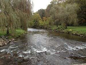
- Largest park in Allentown, 629 acres. Land acquired in 1929, developed by Works Progress Administration (WPA) during the 1930s, providing jobs during the Great Depression years. It is the most prominent park of the city and follows the Little Lehigh Stream for three miles. The park features many scenic exercising trails in addition to bridle paths, a shooting range, and many fishing locations.[1]
- South Lunber and Benton Streets
- Map location: 40°34′32″N 075°27′54″W / 40.57556°N 75.46500°W / 40.57556; -75.46500 (Lumber & Benton Playlot)
- Neighborhood Playground
- 2100 Mack Boulevard
- Map location: 40°34′27″N 075°28′12″W / 40.57417°N 75.47000°W / 40.57417; -75.47000 (Mack Pool)
- City public swimming pool and recreation area
- Mountainville Memorial Youth Association
- West Wabash and South 5th Streets
- Map location: 40°34′54″N 075°27′31″W / 40.58167°N 75.45861°W / 40.58167; -75.45861 (Mountainville Memorial Youth Association)
- Three baseball diamonds, large recreation field
- West Jackson and West Union Street
- Map location: 40°35′55″N 075°28′28″W / 40.59861°N 75.47444°W / 40.59861; -75.47444 (Nice 13 Tot Lot)
- Children's playground
- Old Fairgrounds Playground
- 440 North 5th Street
- Map location: 40°33′55″N 075°28′16″W / 40.56528°N 75.47111°W / 40.56528; -75.47111 (Old Fairgrounds Playground)
- Neighborhood playground
- St. John and South Plumb Streets
- Map location: 40°35′24″N 075°28′31″W / 40.59000°N 75.47528°W / 40.59000; -75.47528 (Patriots Park)
- Baseball diamond, home of the Allentown Patriots softball team (1948-1976). Lights, stands, community building erected in 1957.
- Oxford Drive and Pearl Avenue
- Map location: 40°33′49″N 075°29′38″W / 40.56361°N 75.49389°W / 40.56361; -75.49389 (Percy B. Ruhe Park)
- Formerly Alton Park Recreation Area. Large park, tennis courts, baseball diamonds, picnic and recreation areas
- Camp and South Woodward Streets
- Map location: 40°35′34″N 075°27′22″W / 40.59278°N 75.45611°W / 40.59278; -75.45611 (Roosevelt Park)
- Seven acres in size.[1] Includes baseball diamond, picnic and recreation area
- 3025 Salisbury Street
- Map location: 40°33′51″N 075°29′52″W / 40.56417°N 75.49778°W / 40.56417; -75.49778 (Salisbury Dr Playlot)
- Neighborhood children's playground
- South Mountain Reservoir and Park
- South 10th Street and Reservoir Road
- Map location: 40°33′57″N 075°27′49″W / 40.56583°N 75.46361°W / 40.56583; -75.46361 (South Mountain Reservoir and Park)
- Reservoir area has long circular driving road and large athletic field. Park area has scenic vista point from top of South Mountain
- South & West Mosser Streets
- Map location: 40°34′58″N 075°30′48″W / 40.58278°N 75.51333°W / 40.58278; -75.51333 (South Street Playlot)
- Neighborhood children' playground, picnic and recreation areas
- Island in Lehigh River, accessible only by boat
- Map location: 40°36′36″N 075°25′35″W / 40.61000°N 75.42639°W / 40.61000; -75.42639 (Sterners Island)
- Long, large wooded island. No amenities
- North 6th & West Tilghman Streets
- Map location: 40°36′43″N 075°28′28″W / 40.61194°N 75.47444°W / 40.61194; -75.47444 (Stevens Park)
- Former Stevens Elementary School. Neighborhood children' playground
- Springhouse Road
- Map location: 40°35′33″N 075°31′44″W / 40.59250°N 75.52889°W / 40.59250; -75.52889 (Trexler Memorial Park)
- Former summer home of General Harry Trexler. Deeded to City of Allentown after Trexler's death in 1933. Now large park with lake, long biking road, large grassy and wooded areas for picnicking and recreation. Wild game preserve, home of several hundred ducks, geese and swans.[1] Motor vehicles only allowed in parking area by park entrance.
- South 4th and Harrison Streets
- Map location: 40°35′33″N 075°31′44″W / 40.59250°N 75.52889°W / 40.59250; -75.52889
- Large park along Trout Creek. Long road though park, primarily wooded and grassy areas for picnicking and recreation, baseball field.
- West Turner and North 4th Streets
- Map location: 40°36′23″N 075°27′57″W / 40.60639°N 75.46583°W / 40.60639; -75.46583 (Trout Creek Park)
- Primarily wooded and grassy areas for picnicking and recreation
- South St. Elmo Street
- Map location: 40°35′20″N 075°29′53″W / 40.58889°N 75.49806°W / 40.58889; -75.49806 (Union Terrace)
- Wooded area
- South Law and Union Streets
- Map location: 40°36′02″N 075°28′02″W / 40.60056°N 75.46722°W / 40.60056; -75.46722 (Valania Park)
- Also known as John Valeniz Park. Children's playground, basketball court, wooded area
- South Carbon Street
- Map location: 40°34′17″N 075°27′46″W / 40.57139°N 75.46278°W / 40.57139; -75.46278 (Waldon Terrace Playlot)
- Neighborhood children' playground, basketball court, recreation Field, picnic area
- 1550 West Turner Street
- Map location: 40°35′57″N 075°29′26″W / 40.59917°N 75.49056°W / 40.59917; -75.49056 (West Park)
- Elegant park with walking paths. Includes a community bandshell, now home of the Allentown Band. The park includes ornamental trees flower gardens, and a large central fountain
|
See also
References
External links