List of crossings of the Willamette River
This is a list of bridges and other crossings of the Willamette River in the U.S. state of Oregon from the Columbia River upstream to the confluence of the Middle Fork Willamette River and Coast Fork Willamette River. This confluence, at 44°01′24″N 123°01′26″W / 44.023318°N 123.023897°W / 44.023318; -123.023897 (Willamette River source), is considered the source of the Willamette River.
Portland
| Image |
Crossing |
Carries |
Location |
River mile |
Year built |
Coordinates |
|---|
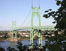 |
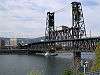
St. Johns Bridge |

 US 30 Byp., sidewalks US 30 Byp., sidewalks |
Portland |
5.8 |
1931 |
45°35′07″N 122°45′52″W / 45.58528°N 122.76444°W / 45.58528; -122.76444 (St. Johns Bridge) |
 |
Burlington Northern Railroad Bridge 5.1 |
BNSF Railway |
Portland |
7.0 |
1908 |
45°34′36″N 122°44′51″W / 45.57667°N 122.74750°W / 45.57667; -122.74750 (Burlington Northern Railroad Bridge 5.1) |
| |
West Side CSO Tunnel |
intercepted sewage overflow |
Portland |
10.0 |
2003 |
45°33′0″N 122°41′52″W / 45.55000°N 122.69778°W / 45.55000; -122.69778 (West Side CSO Tunnel) |
.jpg) |
Fremont Bridge |
 I-405 / US 30 I-405 / US 30 |
Portland |
11.1 |
1973 |
45°32′16″N 122°40′59″W / 45.53778°N 122.68306°W / 45.53778; -122.68306 (Fremont Bridge) |
 |
Broadway Bridge |
Broadway; Portland Streetcar;
sidewalks |
Portland |
11.7 |
1913 |
45°31′55″N 122°40′27″W / 45.53194°N 122.67417°W / 45.53194; -122.67417 (Broadway Bridge) |
 |
Steel Bridge |
Union Pacific Railway
Amtrak
MAX Light Rail
Glisan Street, sidewalks, Interstate Avenue
Eastbank Esplanade (lower level),
formerly Harbor Drive (former  OR 99W) OR 99W) |
Portland |
12.1 |
1912 |
45°31′39″N 122°40′09″W / 45.52750°N 122.66917°W / 45.52750; -122.66917 (Steel Bridge) |
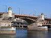 |
Burnside Bridge |
Burnside Street, sidewalks |
Portland |
12.4 |
1926 |
45°31′23″N 122°40′03″W / 45.52306°N 122.66750°W / 45.52306; -122.66750 (Burnside Bridge) |
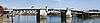 |
Morrison Bridge |
Morrison Street, sidewalks |
Portland |
12.8 |
1958 |
45°31′04″N 122°40′11″W / 45.51778°N 122.66972°W / 45.51778; -122.66972 (Morrison Bridge) |
 |
Hawthorne Bridge |
Hawthorne Boulevard, sidewalks |
Portland |
13.1 |
1910 |
45°30′47″N 122°40′14″W / 45.51306°N 122.67056°W / 45.51306; -122.67056 (Hawthorne Bridge) |
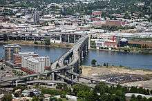 |
Marquam Bridge |
 I-5 I-5 |
Portland |
13.5 |
1966 |
45°30′29″N 122°40′09″W / 45.50806°N 122.66917°W / 45.50806; -122.66917 (Marquam Bridge) |
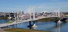 |
Tilikum Crossing |
TriMet MAX Orange Line and buses, Portland Streetcar, sidewalks |
Portland |
13.8 |
2015 |
45°30′20″N 122°39′54″W / 45.50556°N 122.66500°W / 45.50556; -122.66500 (Tilikum Crossing) |
 |
Ross Island Bridge |
 US 26 (Powell Boulevard), sidewalks US 26 (Powell Boulevard), sidewalks |
Portland |
14.0 |
1926 |
45°30′04″N 122°39′52″W / 45.50111°N 122.66444°W / 45.50111; -122.66444 (Ross Island Bridge) |
 |
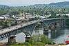
Sellwood Bridge |
Tacoma Street, sidewalks |
Portland |
16.5 |
2016 |
45°27′52″N 122°39′56″W / 45.46444°N 122.66556°W / 45.46444; -122.66556 (Sellwood Bridge) |
Northern Willamette Valley
Middle Willamette Valley
Southern Willamette Valley
Former crossings
See also
Notes
- 1 2 Two former bridges over the Willamette River in Portland were named the Madison Street Bridge. Together, they were active from 1891 to 1909.[3][4]
References
- ↑ Edward Russo (September 15, 2009). "Popular river crossing renamed". The Register-Guard. Eugene, Oregon. p. B1.
- ↑ "Whilamut Passage Bridge Opens". KEZI.com. August 8, 2013.
- ↑ "Hawthorne Bridge: Spanning Willamette River on Hawthorne Boulevard, Portland, Multnomah County, Oregon" (PDF). Historic American Engineering Record, National Park Service, United States Department of the Interior. p. 2. Retrieved August 18, 2016.
- ↑ "Old Span Wrecked; Madison Bridge in Six Weeks Will Be Only Memory". The Morning Oregonian. August 2, 1909. p. 14. Retrieved August 18, 2016.
External links
_-_2.jpg)


_bridge_-_Albany%2C_Oregon.jpg)

.jpg)