Van Buren Street Bridge
| Van Buren Street bridge | |
|---|---|
 | |
| Coordinates | 44°33′56″N 123°15′24″W / 44.5654813°N 123.2565862°WCoordinates: 44°33′56″N 123°15′24″W / 44.5654813°N 123.2565862°W |
| Carries |
|
| Crosses | Willamette River |
| Locale | Corvallis, Oregon |
| Maintained by | Oregon Department of Transportation |
| Characteristics | |
| Design | Swing span |
| Total length | 708 feet (216 m) |
| Longest span | 249 feet (76 m) |
| History | |
| Opened | 1913 |
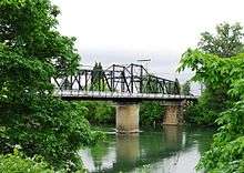
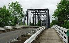
The Van Buren Street Bridge is a swing span, steel motor vehicle bridge spanning the Willamette River at Corvallis in the U.S. state of Oregon. Opened in 1913, the black colored bridge was the first bridge across the river at Corvallis and is now the third oldest bridge across the river. Owned by the state and maintained by the Oregon Department of Transportation (ODOT), the 708-foot (216 m) long span is of a through truss design and carries one lane of traffic of Oregon Route 34 eastbound from Corvallis into neighboring Linn County. The bridge no longer is able to swing open.
History
About 1860 a ferry started crossing the Willamette River at Corvallis.[1] Benton County legislators were able to secure approval to build a bridge at the site as early as 1889.[1] Meanwhile, the county bought the ferry in 1902 and removed the crossing fee.[2] Plans for the bridge across the river were created by Benton County in 1910,[3] and in February 1911 the Oregon Legislature passed a bill that approved the plan to build the bridge.[4] The county signed a contract with the Coast Bridge Company for the steel for a bridge in January 1912.[5]
Work began about June 1912 after a legal delay over funding was resolved, with Corvallis agreeing to pay a larger portion of the project.[6] In November 1912, Corvallis residents passed a bond measure to allow for the city’s portion of funding of the bridge.[7] This vote was the first time women were allowed to vote in a Corvallis election.[7] Construction was completed by the Coast Bridge Company on the project that would cost $70,000[1] to build.[8] Andrew J. Porter was the designer of the span.[9] Funds came from the city, Linn County, private donations, and the largest portion from Benton County.[8] The span was completed in February 1913,[1] with a dedication ceremony on March 11 attended by the mayors of Corvallis and Philomath, as well as the judges for Linn and Benton counties.[1][8] Built as a vehicle crossing, the Oregon Electric Railway had tracks leading to the east side of the bridge shortly after the bridge opened.[10]
The road across the span was originally two-way, plus there was a sidewalk along the south side.[2] On January 25, 1914, the span unexpectedly opened during a windstorm, and trapped a young man on the open swing span section until the bridge operators could row out to the center span and use the turn-key to put the span back into proper position.[2] The state took over ownership of the span in 1938.[8] In June 1952, the span was opened for the first time in 25 years to allow an Army Corp of Engineers vessel to pass, and the span opened for the final time in October 1960.[2] In the 1980s the swivel became inoperable.[11] The bridge was nominated for listing on the National Register of Historic Places about 2006.[12] In March 2007, planned maintenance and re-painting began on the bridge, closing the bridge to traffic at times.[13] The $2.5 million project was completed in October 2007.[14]
Replacement plans
In the 1990s the Oregon Department of Transportation proposed options for replacing the bridge in order to alleviate traffic problems in downtown Corvallis.[15] Funding was never secured and the project was dropped in 1993, but the plans were revived in 2004.[12][15] Plans included options to move the existing structure to a park, leave it in place, and build a new span that could be located in a variety of locations along the river in downtown.[15] These options were narrowed to two in 2006, one adding a bridge parallel to the existing bridge and the other building a curved bridge between the old span and the Harrison Street Bridge.[12] The existing structure would have remained in-place under both options, and costs were estimated at around $18 million.[12][16]
If a new bridge were built, the state originally said they would no longer own and maintain the old bridge, which was proposed to be used for pedestrians and bicycles.[16] Linn County’s Board of Commissioners supported tearing down the old bridge and simply replace it with a new wider span.[17] In June 2006, ODOT decided to keep the existing span in addition to the new bridge.[18] Additional studies began in 2007 to determine which of the options for replacement would work best for fixing traffic issues across the river.[11] Options now included adding a bypass north to connect with Oregon Route 99W.[11] By May 2009, ODOT had two proposals, one of which would not build a new bridge near the existing span.[19] Both options included adding a northern bypass that would connect to U.S. Route 20 and Oregon 99W.[19]
As of 2015 the plans for a new bridge had been set aside, with improvements to the south bypass and downtown exits for OR 34, OR 20, and 99 W intended to ease congestion instead. The future northern bypass is considered by planners to be a long term goal, as there is no schedule and none of the estimated $250 million cost has been budgeted.[20]
Details
The bridge was the first bridge across the Willamette River at Corvallis.[16] Carrying one lane of traffic eastbound, it connects Benton County on the west to Linn County on the east side of the Willamette.[17] It carries Oregon Route 34 out of downtown Corvallis, with the Harrison Street Bridge to the north carrying OR 34 into downtown.[17] The single lane creates traffic problems at the evening rush hour with three lanes of the highway narrowing to one lane to cross the bridge.[11]
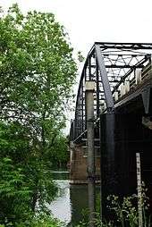
A swing bridge, its main 249-foot (76 m)-span could swivel on its axis and open to allow river traffic to pass.[16] This is accomplished by using a turn key placed into the turning bolt and rotating the bolt.[8] Six people would rotate the key using a 17-foot (5.2 m) long wood rod that combined resemble a corkscrew.[8] This would turn the 24-foot (7.3 m) wide gear that had 300 teeth along its circumference and the span would spin along 42 rollers constructed of steel.[8] The operators could use two gears, one opened the span in 150 revolutions, while the other completed the job in 50 revolutions.[8] When opened it provided 102 feet (31 m) of clearance on either side of the bridge.[21]
Van Buren Street Bridge is the last movable-span truss bridge constructed by the pin connection method located on the West Coast.[17] Pins were used to connect the trusses, but the technique was abandoned after rivets came into usage.[8] The bridge is also one of only two swing style bridges left in Oregon used for vehicle traffic,[11] and is the third oldest bridge across the Willamette after the Steel and Hawthorne bridges in Portland.[11]
Overall, the bridge is 708 feet (216 m) long and is composed of three separate steel spans that rest on concrete piers.[21][22] The swing span is a Pratt through truss, and the next longest part a 171-foot (52 m) long Parker through truss span on the western end.[21] The eastern approach is a Warren pony truss that measures 57 feet (17 m) in length.[21] There is also a 19-foot (5.8 m) long part on the far west end built of timber, which was originally a 57-foot (17 m) long steel pony truss.[21] The bridge has 15 feet (4.6 m) of vertical clearance and is 29 feet (8.8 m) wide, which includes a 7-foot (2.1 m) sidewalk and a 18.5-foot (5.6 m) roadway.[21]
See also
References
- 1 2 3 4 5 "Corvallis Residents Celebrate Opening of $70,000 Wagon Bridge". The Oregonian. March 16, 1913. p. 15.
- 1 2 3 4 The Van Buren Street Bridge. Benton County Historical Society. Sign in Riverfront Park, Corvallis, Oregon.
- ↑ "Corvallis Wants Bridge". The Oregonian. December 2, 1910. p. 15.
- ↑ "Two Bridges are Wanted". The Oregonian. February 17, 1911. p. 6.
- ↑ "Corvallis to Benefit". The Oregonian. January 27, 1912. p. 6.
- ↑ "Corvallis Builds Bridge". The Oregonian. May 12, 1912. p. 2.
- 1 2 Lynn Walker, Morris Walker (January 25, 2008). "Clips In Time: History makes history". Corvallis Gazette-Times.
- 1 2 3 4 5 6 7 8 9 Lynn Walker, Morris Walker (February 22, 2008). "In 1913, Van Buren Bridge was the span of the future". Corvallis Gazette-Times.
- ↑ "Van Buren Street Bridge". Oregon Historic Sites Database. Oregon Parks & Recreation Department. Retrieved 2009-10-09.
- ↑ "New Bridge Dedicated". The Oregonian. March 12, 1913. p. 7.
- 1 2 3 4 5 6 Odegard, Kyle (July 27, 2007). "Seeking a solution to bridge gridlock". Corvallis Gazette-Times.
- 1 2 3 4 Barrett, Rebecca (April 8, 2006). "Van Buren's future". Corvallis Gazette-Times.
- ↑ "Bridge closure begins". Corvallis Gazette-Times. March 19, 2007.
- ↑ "Van Buren bridge to close again". Corvallis Gazette-Times. September 3, 2007.
- 1 2 3 Geist, Wendy (November 9, 2004). "ODOT presents Van Buren Bridge options". Corvallis Gazette-Times. p. A3.
- 1 2 3 4 Rollins, Ian (April 22, 2006). "Linn board says bridge should be torn down". Albany Democrat-Herald.
- ↑ Barrett, Rebecca (June 23, 2006). "ODOT narrows bridge options". Corvallis Gazette-Times.
- 1 2 Odegard, Kyle (May 14, 2009). "ODOT presents Van Buren bridge alternatives". Corvallis Gazette-Times. Retrieved 2009-10-09.
- ↑ Hall, Bennett (February 15, 2015). "ODOT starting work on revised project to ease Highway 34 traffic out of Corvallis". Corvallis Gazette-Times. Retrieved April 21, 2015.
- 1 2 3 4 5 6 Chapman, J. Sanders (July 24, 1984). "Oregon Inventory of Historic Properties Historic Resource Survey Form: Van Buren Street Bridge" (PDF). City of Corvallis. Retrieved 2009-10-09.
- ↑ "Van Buren Street Bridge". Structurae. Nicolas Janberg ICS. Retrieved 2009-10-09.
External links
| Crossings of the Willamette River | ||||
|---|---|---|---|---|
| ||||