List of islands of Bothnian Bay

A list of islands of Bothnian Bay would include 4,001 islands if an island is defined as an area of land more than 20 square metres (220 sq ft) that is surrounded by water.[1]
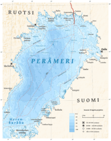
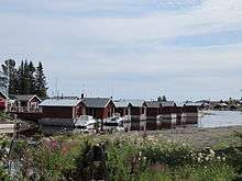
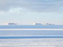
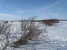
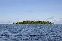
Bothnian Bay (Swedish: Bottenviken, Finnish: Perämeri) is divided between northern Sweden and Finland.[1] The north of the bay contains a large archipelago area.[2] The largest island is Hailuoto, further south on the Finnish side.[2] In the winter the larger islands may be accessed via ice roads. Some of them are inhabited or have seasonal fishing villages used by people from the mainland.[1]
Swedish islands
The Swedish islands in the north of the bay may be grouped into the Piteå, Luleå, Kalix and Haparanda archipelagos.[3] Many of the islands are uninhabited and in a natural state.[4] There are other islands along the Swedish coast to the south of the archipelago area.
Piteå
Some of the larger islands in the Piteå archipelago include:
Luleå
Some of the larger islands in the Luleå archipelago include:[5]
Kalix
Some of the larger islands in the Kalix archipelago include:
Haparanda
The Swedish Haparanda Archipelago National Park (Swedish: Haparanda skärgårds nationalpark) lies within the Haparanda group of islands, bordering the Finnish Bothnian Bay National Park. It includes the larger islands of Sandskär and Seskar Furö, and some smaller islands and skerries. All of these islands have emerged in the last 1,500 years as the bed of the bay has risen.[6] Some of the larger islands in Haparanda archipelago include:[7]
Other Swedish islands
Finnish islands
In the portion of the bay that belongs to Finland the majority of islands lie in the section between Tornio on the Swedish border and the large island of Hailuoto offshore from Oulu, although there are many small islands along the coast to the south. The Bothnian Bay National Park in the Finnish section (Finnish: Perämeren kansallispuisto, Swedish: Bottenvikens nationalpark), established in 1991, is located in the archipelago offshore from Tornio and Kemi. It covers 157 square kilometres (61 sq mi) of which about 2.5 square kilometres (0.97 sq mi) is land.[8]
Tornio municipality
Islands in the Tornio municipality beside the Swedish municipality of Haparanda include:
- Inakari
- Iso-Huituri (Tornio and Kemi)
- Kuusiluoto
- Pajukari
- Pensaskari
- Röyttä
Kemi municipality
Islands in the Kemi municipality to the east of Tornio, at the mouth of river Kemijoki, include:
- Ajos
- Inakari
- Keilakrunni
- Kemin Kiikkara
- Keminkraaseli
- Pohjois-Kraaseli
- Rautakallio
- Selkä-Sarvi
- Täikkö
- Täikönkari
Simo municipality
Islands in the Simo municipality at the mouth of river Simojoki include:
- Halttari
- Härkäletto
- Laitakari
- Leipäreet
- Lissabon
- Montaja
- Möyly
- Ööperit
- Paskaletto
- Pirttisaari
- Rajaletto
- Saapaskari
- Tiuranen
- Tiurasenkalla
- Tiurasenkrunni
- Tynttyrit
- Ykskivi
Ii municipality
Islands in the Ii municipality at the mouth of river Iijoki include:
- Hietakalla, Vatunki
- Hietakalla, Hiastinlahti
- Hylkikalla
- Iin Röyttä
- Illinsaari
- Karhu
- Koni
- Krassinletto
- Kriisi
- Krunnien saaristo
- Kuivamatala
- Kutinkalla
- Onsajanmatala
- Pallonen
- Pensaskari
- Ryöskärinkalla
- Santapankki
- Satakari
- Selkäletto
- Tangonsaari
- Ulko-Klaama
- Ulko-Pallonen
- Ulkokrunni
Haukipudas municipality
Islands in the former Haukipudas municipality include:
- Äijänkumpele
- Astekari
- Hanhikari
- Hietakari
- Hiuvet
- Hopreeni
- Iso-Miehikkä
- Isonkivenletto
- Kaasamatala,
- Kattilankalla
- Kellon Kraaseli
- Kintasletto
- Kotakari
- Kriisinkivi
- Kropsu
- Laitakari
- Lemmonletto
- Luodeletto
- Länsiletto
- Lönkytin
- Mustakari, Virpiniemi
- Mustakari, Martinniemi
- Nimetön
- Pensaskari
- Pulkkisenmatala (Haukipudas/Oulu)
- Puukkoletto
- Rapakari
- Rivinletto
- Satakarinletto
- Välikari
- Väliletto
- Ykskivi
Oulu municipality
Islands in the Oulu municipality include:
- Hermannit
- Hietasaari
- Kahvankari
- Korkiakari
- Laitakari
- Riitankari
- Runniletto
- Saapaskari
- Selkäkari
- Toppilansaari
- Vihreäsaari
Other Finnish islands
Other islands in the Finnish part of the bay include.
- Akio, Oulunsalo
- Haahka
- Hailuoto, Hailuoto
- Iso-Kraaseli, Raahe
- Kallankarit, Kalajoki
- Kammonkari, Oulunsalo
- Karinkannanmatala, Siikajoki
- Kello, Raahe
- Kengänkari, Hailuoto
- Kolmenkoivunkari, Oulunsalo
- Kotakari, Oulunsalo
- Kraaseli, Oulunsalo
- Kraaselinpauha, Lohtaja
- Kumpele, Raahe
- Lamunkari, Lumijoki
- Maluri, Haaparanta
- Ohtakari,
- Parmiinit, Oulunsalo
- Puluvärkki, Raahe
- Rautakallio, Siikajoki
- Rokonkari, Lumijoki
- Sanskeri, Haaparanta
- Santosenkari, Hailuoto
- Seittenkaari, Haaparanta
- Tasku, Raahe
- Ulkolaidanmatala, Hailuoto
- Ulkopauha, Raahe
- Varjakansaari, Oulunsalo
Notes
References
- "About the Bay of Bothnia". Bottenvikens skärgård. Retrieved 2013-09-30.
- Ankre, Rosemarie (2005). "A Case Study of the Luleå archipelago, Sweden" (PDF). Mid-Sweden University. Retrieved 2013-10-04.
- "Bay of Bothnia National Park". Lapland Travel Info. Retrieved 2013-09-30.
- "Haparanda Skärgård National Park". Swedish Environmental Protection Agency. Retrieved 2013-10-02.
- "Index". bottenviken.se. Retrieved 2013-10-02.
- Leppäranta, Matti; Myrberg, Kai (2009-03-20). Physical Oceanography of the Baltic Sea. Springer. p. 55. ISBN 978-3-540-79703-6. Retrieved 2013-10-01.
- "Öar i Haparanda skärgård". bottenviken.se. Retrieved 2013-10-10.
- Sweden. Rough Guides. 2003. ISBN 978-1-84353-066-4. Retrieved 2013-10-02.