Litenčice
| Litenčice | |||
|---|---|---|---|
| Městys | |||
 | |||
| |||
 Litenčice | |||
| Coordinates: 49°11′56″N 17°12′16″E / 49.19889°N 17.20444°ECoordinates: 49°11′56″N 17°12′16″E / 49.19889°N 17.20444°E | |||
| Country |
| ||
| Region | Zlín | ||
| District | Kroměříž | ||
| Area | |||
| • Total | 10.51 km2 (4.06 sq mi) | ||
| Elevation | 358 m (1,175 ft) | ||
| Population (2006) | |||
| • Total | 470 | ||
| • Density | 45/km2 (120/sq mi) | ||
| Postal code | 768 13 | ||
| Website | http://www.litencice.com | ||

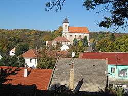
Litenčice (German: Litentschitz) is a market town (městys) in Kroměříž District in the Zlín Region of the Czech Republic.
Geography
The town is located within the Litenčice Hills in the historic Moravia region, approximately 18 kilometres (11 mi) south-west of Kroměříž, 34 km (21 mi) west of Zlín, and 224 km (139 mi) south-east of Prague.
The town covers an area of 10.51 square kilometres (4.06 sq mi), and has a population of 470 (as at 28 August 2006).
History
Archaeological findings of an early mediæval burial site denote a settlement already during the Great Moravian realm. Lutincicih was first mentioned in a 1141 deed issued by Jindřich Zdík, Bishop of Olomouc, in a rental of the Spytihněv archdeaconry.
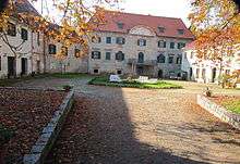
From the mid 14th century, Lyvtenczicz Castle served as the seat of several Moravian noble families. First documented in 1437, when it was held by the Zástřizl dynasty, it was largely rebuilt as a Baroque palace in the 17th century under Péter Pázmány, Archbishop of Esztergom.
References
| Wikimedia Commons has media related to Litenčice. |