Little Luckiamute River
| Little Luckiamute River | |
 | |
| Name origin: Native American but of unknown meaning[1] | |
| Country | United States |
|---|---|
| State | Oregon |
| County | Polk |
| Source | Central Oregon Coast Range |
| - location | near Fanno Peak |
| - elevation | 2,869 ft (874 m) [2] |
| - coordinates | 44°52′45″N 123°37′37″W / 44.87917°N 123.62694°W [3] |
| Mouth | Luckiamute River |
| - location | about 4 miles (6 km) upstream of Sarah Helmick State Recreation Site |
| - elevation | 203 ft (62 m) [3] |
| - coordinates | 44°47′28″N 123°17′17″W / 44.79111°N 123.28806°WCoordinates: 44°47′28″N 123°17′17″W / 44.79111°N 123.28806°W [3] |
| Length | 24 mi (39 km) [4] |
| Basin | 54 sq mi (140 km2) [5] |
 Location of the mouth of the Little Luckiamute River in Oregon | |
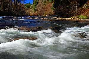
The Little Luckiamute River is a stream in Polk County in the U.S. state of Oregon. It rises in the Central Oregon Coast Range near Fanno Peak and joins the Luckiamute River about 4 miles (6 km) upstream of the Sarah Helmick State Recreation Site southwest of Monmouth.[4]
Flowing generally east from its source near Fanno Peak, the river parallels Fanno Ridge, which is to the right. Lost Creek enters from the left at a rapids, and Camp Creek enters from the left 20.6 miles (33.2 km) from the mouth. About 0.5 miles (0.80 km) further on, the river passes over a waterfall. Approaching the unincorporated community of Black Rock, Little Luckiamute River receives Black Rock Creek from the left at river mile (RM) 17 or river kilometer (RK) 27. For several miles starting at Black Rock, the George T. Gerlinger Experimental Forest is on the river's left. Sam's Creek enters from the left about 1 mile (1.6 km) downstream of Black Rock.[4][6]
Gerlinger County Park is on the right at RM 15 (RK 24). Dutch Creek enters from the left and Berry Creek from the right before the river reaches Falls City Falls and Falls City about 13 miles (21 km) from the mouth.[4][6] At the falls, the river plunges 25 to 35 feet (7.6 to 10.7 m) into a gorge within a city park.[7] Turning southeast, the river receives Waymire Creek from the left, then Teal Creek from the right, then passes under Oregon Route 223 at about RM 8 (RK 13). Fern Creek enters from the left just beyond Route 223, and Cooper Creek enters from the left about 1.5 miles (2.4 km) from the mouth. The Little Luckiamute River meets the Luckiamute River about 18 miles (29 km) from the larger river's confluence with the Willamette River.[4][6]
The upper river supports catch-and-release fishing for wild coastal cutthroat trout ranging in size from 6 to 13 inches (15 to 33 cm).[8]
See also
References
- ↑ McArthur, Lewis A.; McArthur, Lewis L. (2003) [1928]. Oregon Geographic Names, 7th ed. Portland, Oregon: Oregon Historical Society Press. pp. 597–98. ISBN 0-87595-277-1.
- ↑ Source elevation derived from Google Earth search using GNIS source coordinates.
- 1 2 3 "Little Luckiamute River". Geographic Names Information System (GNIS). United States Geological Survey. November 28, 1980. Retrieved October 25, 2011.
- 1 2 3 4 5 "United States Topographic Map". United States Geological Survey. Retrieved March 4, 2016 – via Acme Mapper. The map quadrants include river-mile (RM) markers to RM 20.6 (river kilometer 33.2). The remaining distance is an estimate based on map scale and ruler.
- ↑ Marys Peak Resource Area support team (September 1998). "Rowell Creek, Mill Creek, Rickreall Creek, Luckiamute River Watershed Analysis" (PDF). Bureau of Land Management. p. R&CC-17. Retrieved October 24, 2011.
- 1 2 3 Oregon Atlas & Gazetteer. Freeport, Maine: DeLorme Mapping. 1991. pp. 52–53. ISBN 0-89933-235-8.
- ↑ Plumb, Gregory A. (2004). Waterfall Lover's Guide: Pacific Northwest (4th ed.). The Mountaineers Books. p. 195. ISBN 0-89886-911-0.
- ↑ Sheehan, Madelynne Diness. Fishing in Oregon (10th ed.). Scappoose, Oregon: Flying Pencil Publications. pp. 149–50. ISBN 0-916473-15-5.