Luckiamute River
| Luckiamute River | |
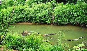 Luckiamute River at Sarah Helmick State Recreation Site | |
| Name origin: Native American but of unknown meaning[1] | |
| Country | United States |
|---|---|
| State | Oregon |
| County | Polk and Benton |
| Source | Central Oregon Coast Range |
| - location | near Bald Mountain, Polk County |
| - elevation | 2,684 ft (818 m) [2] |
| - coordinates | 44°47′28″N 123°32′45″W / 44.79111°N 123.54583°W [3] |
| Mouth | Willamette River |
| - location | near Buena Vista, Polk County |
| - elevation | 157 ft (48 m) [3] |
| - coordinates | 44°45′15″N 123°08′54″W / 44.75417°N 123.14833°WCoordinates: 44°45′15″N 123°08′54″W / 44.75417°N 123.14833°W [3] |
| Length | 61 mi (98 km) [4] |
| Basin | 315 sq mi (816 km2) [5] |
| Discharge | for Helmick State Recreation Site, 13.5 miles (21.7 km) from the mouth |
| - average | 872 cu ft/s (25 m3/s) [6] |
| - max | 32,900 cu ft/s (932 m3/s) |
| - min | 0.65 cu ft/s (0 m3/s) |
 Location of the mouth of the Luckiamute River in Oregon | |
The Luckiamute River is a tributary of the Willamette River, about 61 miles (98 km) long, in western Oregon in the United States.[4] It drains an area of Central Oregon Coast Range and the western Willamette Valley northwest of Corvallis.[7]
It rises in the remote mountains of southwestern Polk County, about 10 miles (16 km) west of Pedee. It flows southeast to Hoskins in Benton County, then northeast into Polk County, past Pedee, then east across southern Polk County. It is joined from the northwest by the Little Luckiamute River. It joins the Willamette from the west about 10 miles (16 km) north of Albany. The mouth of the river is about 1⁄4 mile (400 m) downstream from the mouth of the Santiam River, which enters the Willamette from the east 108 miles (174 km) upstream of the Willamette's mouth on the Columbia River.[8]
Named tributaries from source to mouth are Boulder, Beaver, Miller, Wolf, Rock Pit, Slick, Cougar, Slide, and Harris creeks. Further downstream are Hull, Foster, Jones, Bonner, Vincent, Plunkett, and Price creeks. Maxfield Creek is next followed by Bump, Ritner, Pedee, McTimmonds, Link, Dry, and Jont creeks followed by the Little Luckiamute River. Soap Creek enters the main stem along the Luckiamute's lower reaches.[8]
The Luckiamute Watershed Council includes Ash Creek in its watershed study area, although it drains directly into the Willamette River.[5]
See also
References
- ↑ McArthur, Lewis A.; McArthur, Lewis L. (2003) [1928]. Oregon Geographic Names, 7th ed. Portland, Oregon: Oregon Historical Society Press. pp. 597–98. ISBN 0-87595-277-1.
- ↑ Source elevation derived from Google Earth search using GNIS source coordinates.
- 1 2 3 "Luckiamute River". Geographic Names Information System (GNIS). United States Geological Survey. November 28, 1980. Retrieved September 2, 2010.
- 1 2 Palmer, Tim (2014). Field Guide to Oregon Rivers. Corvallis: Oregon State University Press. pp. 176–77. ISBN 978-0-87071-627-0.
- 1 2 "Luckiamute Watershed". Luckiamute Watershed Council. Archived from the original on September 8, 2015. Retrieved October 4, 2015.
- ↑ "Water-Data Report 2010: 14190500 Luckiamute River near Suver, OR" (PDF). United States Geological Survey. Retrieved October 24, 2011.
- ↑ Oregon Atlas & Gazetteer (1st ed.). Freeport, Maine: DeLorme Mapping. 1991. pp. 52–53. ISBN 0-89933-235-8.
- 1 2 "United States Topographic Map". United States Geological Survey. Retrieved March 4, 2016 – via Acme Mapper. The map includes mile markers along the Willamette and Luckiamute rivers.