Littleton/Route 495 (MBTA station)
LITTLETON / RTE 495 | |||||||||||
|---|---|---|---|---|---|---|---|---|---|---|---|
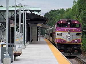 A train at the newly rebuilt station in July 2013 | |||||||||||
| Location |
Grimes Lane & Foster Street Littleton, MA | ||||||||||
| Coordinates | 42°31′11″N 71°30′10″W / 42.51967°N 71.50264°WCoordinates: 42°31′11″N 71°30′10″W / 42.51967°N 71.50264°W | ||||||||||
| Line(s) | |||||||||||
| Platforms | 1 island platform | ||||||||||
| Tracks | 2 | ||||||||||
| Construction | |||||||||||
| Structure type | At-grade | ||||||||||
| Parking |
194 spaces ($4.00 daily) 6 accessible spaces | ||||||||||
| Disabled access | Yes | ||||||||||
| Other information | |||||||||||
| Fare zone | 7 | ||||||||||
| History | |||||||||||
| Opened | 1980; June 3, 2013 | ||||||||||
| Traffic | |||||||||||
| Passengers (2013) | 313 (weekday inbound average)[1] | ||||||||||
| Services | |||||||||||
| |||||||||||
Littleton/Route 495 is a passenger rail station on the MBTA Commuter Rail Fitchburg Line located in Littleton, Massachusetts. The station is located at the intersection of Grimes Lane and Foster Street near Route 2 and I-495 and serves as a park-and-ride station for both highways.
A previous station was open at King Street in West Littleton until 1975. Littleton/Route 495 station opened several miles away in 1980 as an inexpensive park-and-ride to gather commuters from the northwest Boston suburbs. In 2011, work began on the construction of a new station, with a full-length handicapped accessible platform and a pedestrian bridge to the parking lot, as part of a larger project to improve the Fitchburg Line. After about 16 months of construction, the new station and pedestrian bridge opened in June 2013.
History
Littleton Depot


The Fitchburg Railroad was extended westward from Cambridge between 1843 and 1845, reaching Littleton around November 1844.[2]:202 Residents at Littleton Common did not like the appearance of the railroad, so it was routed through what was called West Littleton or Harwood Junction instead.[3]:129 A large two-story station was placed there at the intersection of King Street and Taylor Street.[4] The long building included separate rooms for passengers and freight, and a living area for the station master. In 1879, the Fitchburg replaced it with a Victorian-style depot building a few feet to the east. The old station was moved south on Taylor Street and served as an apartment building for some time thereafter.[3]:130
Residents were not allowed to ride trains on Sundays until 1850, and for some time thereafter only for the purpose of attending religious services.[3]:143 Despite minor accidents in 1845 and 1849, and a crash of the Tunnel Express on October 7, 1880 which killed two passengers, the railroad became important to daily life in Littleton. Freight including building materials, apples, and milk were shipped from several locations, including the depot. Much of the cattle transported on the line between 1885 and 1930 passed through the quarantine station in Littleton. The railroad also delivered the daily mail, its primary source of profit.[3]:131, 146, 250–251 The station became a center of local commerce and industry, with both housing and businesses erected around Depot Square.[3]:250
Several plans were made between 1900 and 1906 to construct a street railway, but no construction took place. The B&M secured a bus franchise in the town in 1926.[3]:205
Service continued to the Littleton station for over 120 years, run by the Fitchburg Railroad until 1900 and thereafter by the Boston and Maine Railroad (B&M). Fifteen cars on a B&M freight derailed at Littleton on May 27, 1956, injuring one resident and blocking the main line for days.[3]:361 The B&M began to sharply cut back passenger service in the early 1960s, but in 1964 the newly formed Massachusetts Bay Transportation Authority (MBTA) began to subsidize their northside commuter services.[5]:327 However, on January 18, 1965, funding cuts resulted in Fitchburg Line service being cut back to West Concord. After subsidy arrangements were made with several towns, service was partially extended back to Ayer – including the Littleton stop – on June 28, 1965.[5]:328
The depot building was closed in 1970, leaving passengers to wait at the crossing. The building was occupied for a time by McElroy Manfucturing Corporation (a telegraph producer) then later that year by Learning Things (an educational product developer). In 1976, it was bought and restored to original condition by David Erikson, who operates Erikson's Antique Stoves from the building.[3]:402–403[6]
In December 1973, state subsidies for towns outside the MBTA funding district were halved, resulting in the MBTA needing to renegotiate subsidies from 14 municipalities. Littleton, with just 21 daily commuters, refused to pay its $12,300 bill in 1974; Ayer also failed to reach an agreement.[7] On March 1, 1975, the line was cut back to South Acton, dropping the stops at Ayer, Littleton, and West Acton.[5][8]
Littleton/Route 495
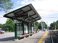
On December 27, 1976, the MBTA bought the B&M's northside commuter rail assets, including the entire length of the Fitchburg Line.[5]:332–333 The closure of the Lexington Branch the next month represented the limit of the contraction of the northside lines; as a results of the 1970s energy crisis and especially the 1979 energy crisis, a period of rapid expansion began in the end of the 1970s. On January 13, 1980, service was extended back to Fitchburg and on to Gardner. However, the previous station location in West Littleton offered little to no parking space, and it was not reopened. A new station, Littleton/Route 495, opened some 1.6 miles (2.6 km) to the southeast, using spare parking lots from an adjacent industrial firm.[5]:335 It was located on Foster Street just off the interchange of Route 2 and I-495, and named after the latter. The station consisted of a 200-foot (61 m)-long low-level asphalt platform with a bus stop-style shelter.[9] A small canopy shelter was added later.
From 1981 until the 1990s, Littleton was the turnback point for a limited number of trains.[9] Its parking lot was just 40 spaces, insufficient for demand. In 1995, local officials proposed building a new station on a state highway parcel off Route 2A, as the Foster Street site was considered too rural for a garage. However, at the time, the MBTA was focused on reactivating the Old Colony Lines and was not adding parking to existing stations.[10]
New station
As part of a $159 million upgrade project on the Fitchburg line, Littleton/Route 495 station was completely rebuilt in 2012-13. A second track was added from South Acton to Ayer through Littleton, which necessitated replacement of the low-level platform that occupied the track slot. Additionally, the 1980-built station was not accessible for handicapped riders and could not accommodate the full length of trains. The new station, which was built just outbound of the 1980-built platform, has an 800-foot-long high-level platform for speedy, fully handicapped accessible boarding. A pedestrian bridge with ramps connects the platform to the parking lot.
Bidding for the new construction opened on 18 August 2011, with the bidding period lasting until September 20.[11] Construction work on the new platform started in early 2012; the platform was in place by mid-summer, and the main span of the pedestrian bridge was lifted into place in early November. The new station and bridge opened on June 3, 2013; a ceremony was held with public officials later that month.[12] The 1980-built platform was demolished soon after the new station opened.
South Acton was previously the short turn terminus of some trains; however, those trains were extended to Littleton effective August 4, 2014.[13] The completion of the new two-track station allows local such terminating trains to board on one track while another train passes on the other track; the design of the station with an island platform (instead of two side platforms) eliminates confusion as to which platform such terminating trains would serve.
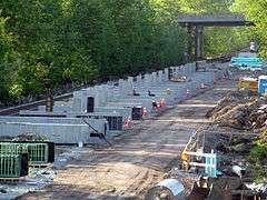 New platform supports under construction in May 2012
 New platform installed and pedestrian overpass under construction behind the old station in August 2012
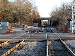 Second track through the Foster Street crossing and new interlocking installed in 2012
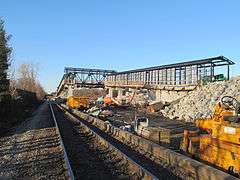 Pedestrian bridge under construction in November 2012
Future plans
Expanded service and parking at Littleton is expected to mitigate the current parking lot overcrowding at South Acton.[14] To replace the 44-space lot at Littleton that was removed for construction access, the MBTA bought a 194-space private lot nearby and added an off-street drop-off area.[15] The additional parking has proved so popular that in 2014, Littleton town officials considered the construction of a 200-space garage.[16] A September 2014 parking study recommended adding parking on adjacent properties, implementing a shuttle service from residential areas, and adding bicycle storage areas and sidewalks to increase bicycle and pedestrian arrivals.[17]
In late 2015, the MBTA added 24 parking spaces off Grimes Lane as an interim measure.[18]
Other Littleton stations
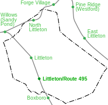

Several other railroad stations, now closed, were located in or adjacent to Littleton.
North Littleton station was located on the Stony Brook Railroad at Great Road (MA 119).[19] The line opened in July 1848, and local passenger service ran until April 1953, with a single Budd RDC trip lasting until around the end of 1960.[2]:213–214 However, North Littleton station had been closed decades earlier in 1914 and torn down in 1928.[20] While open, it had been a flag stop for local trains as well as the overnight State of Maine Express.[3]:249
The Stony Brook also served two stops just outside Littleton. Forge Village was located at Pleasant Street (MA 225) in Forge Village in Westford.[19] Willows (also called Sandy Pond) was a combined station with the Fitchburg Railroad, located at their junction at Willow Road in Ayer.[2][19]
Besides Willows and Littleton, the Fitchburg Railroad also stopped at Boxboro station at Depot Road, just south of the Littleton town line.[2] (Boxborough did not fully separate from Littleton until 1890).[3]:102–103 However, West Acton station was closer to Boxboro proper, and the Boxboro stop was abandoned by 1935.[21]
The Nashua, Acton and Boston Railroad, which ran from Concord to Nashua, ran through Westford with two stations near the eastern part of Littleton. Passenger service on the line ran from 1876 to 1924.[2] East Littleton station was located at Littleton Road (MA 110), about a mile east of Littleton Common.[21] It received frequent shipments of coal and grain for the Conant and Company store nearby.[3]:249 Pine Ridge station (also known as Westford) was located at Patten Road.[2][21]
References
- ↑ "Ridership and Service Statistics" (PDF) (14 ed.). Massachusetts Bay Transportation Authority. 2014. Retrieved 26 June 2014.
- 1 2 3 4 5 6 Karr, Ronald Dale (1995). The Rail Lines of Southern New England. Branch Line Press. pp. 200–205, 212–217. ISBN 0942147022.
- 1 2 3 4 5 6 7 8 9 10 11 Himmelberger, Ann; Hobausz, Melinda; Stein, Linda, eds. (2014). Littleton, Massachusetts 1714-2014: Celebrating 300 Years of History. Littleton Historical Society. ISBN 9780615902357.
- ↑ Roy, John H. Jr. (2007). A Field Guide to Southern New England Railroad Depots and Freight Houses. Branch Line Press. p. 181. ISBN 9780942147087.
- 1 2 3 4 5 Belcher, Jonathan (12 November 2012). "Changes to Transit Service in the MBTA district" (PDF). NETransit. Retrieved 12 October 2015.
- ↑ Erickson, David. "Erickson's Antique Stoves". Retrieved 19 August 2011.
- ↑ Amory, David (20 January 1975). "MBTA puts bigger bite on 14 'outside' towns for rail costs". Boston Globe. Retrieved 19 January 2014 – via ProQuest Historical Newspapers. (subscription required (help)).
- ↑ O'Keele, John (2 March 1975). "MBTA ends Boston & Maine's Ayer, Littleton, West Acton service; cites deficit". Boston Globe. Retrieved 19 January 2014 – via ProQuest Historical Newspapers. (subscription required (help)).
- 1 2 Humphrey, Thomas J. & Clark, Norton D. (1985). Boston's Commuter Rail: The First 150 Years. Boston Street Railway Association. pp. 89–90, 94. ISBN 9780685412947.
- ↑ Dabilis, Andy (7 May 1995). "Town would consider lot, station elsewhere: Parking site for Littleton railroad assailed". Boston Globe – via Proquest Historical Newspapers. (subscription required (help)).
- ↑ "Construction Bid Solicitation for Littleton Commuter Rail Improvement Project". Massachusetts Bay Transportation Authority. 18 August 2011. Retrieved 19 August 2011.
- ↑ Kost, Joel (22 June 2013). "Littleton MBTA station upgraded". Lowell Sun. Retrieved 22 June 2013.
- ↑ "Fitchburg Line Schedule" (PDF). Massachusetts Bay Transportation Authority. 4 August 2014. Archived from the original (PDF) on 30 July 2014. Retrieved 30 July 2014.
- ↑ Martin, David (5 January 2012). "South Acton Train Station Project Information". Acton Patch. Retrieved 10 August 2015.
- ↑ "New Littleton Commuter Rail Station Opens". Massachusetts Bay Transportation Authority. 21 June 2013. Retrieved 25 June 2013.
- ↑ Lefferts, Jennifer Fenn (9 January 2014). "Fitchburg commuter line improvements to be finished by end of 2015". Boston Globe. Archived from the original on 13 January 2014. Retrieved 12 January 2014.
- ↑ Metropolitan Area Planning Council (September 2014). "Littleton Commuter Rail Parking" (PDF). Town of Littleton. Retrieved 7 July 2015.
- ↑ Silva, Alexander (4 January 2016). "Littleton MBTA station getting more stops and parking". Wicked Local Littleton. Retrieved 6 January 2015.
- 1 2 3 United States Geographic Survey (1936). "Groton, MA-NH Quadrangle". USGS 15 Minute Series. University of New Hampshire. Retrieved 25 December 2012.
- ↑ Bowers, Nancy (2009). "North Littleton Station". Littleton Historical Society. Retrieved 26 December 2012.
- 1 2 3 United States Geographic Survey (1935). "Lowell, MA-NH Quadrangle". USGS 15 Minute Series. University of New Hampshire. Retrieved 25 December 2012.
External links
| Wikimedia Commons has media related to Littleton/Route 495 (MBTA station). |
| Wikimedia Commons has media related to Littleton (B&M station). |