Logan Pass
| Logan Pass | |
|---|---|
|
Logan Pass | |
| Elevation | 6,646 ft (2,026 m) |
| Traversed by | Going-to-the-Sun Road |
| Location |
Flathead / Glacier counties, Montana, United States |
| Range | Lewis Range |
| Coordinates | 48°41′47.72″N 113°43′5.91″W / 48.6965889°N 113.7183083°W |

Logan Pass (elevation 6,646 ft (2,026 m)) is located along the Continental Divide in Glacier National Park, in the U.S. state of Montana. It is the highest point on the Going-to-the-Sun Road.


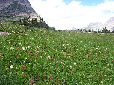
The Logan Pass Visitor Center is open during the summer season just east of the pass. The pass is a popular starting point for hiking and backpacking trips. The most popular trail is the Highline Trail which heads north along the west side of the continental divide, through an area known as the Garden Wall, due to the proliferation of wildflowers which grow there during the summer.
Just east of the pass, an area known as Big Drift often records over 100 feet (30 m) of snowfall, much of which has been pushed over the continental divide by the prevailing westerly winds during the winter. The pass is closed during the winter due to avalanche hazards and the virtual impossibility of keeping the Going-to-the-Sun Road open, yet is generally open from the end of May until mid October.
A record wind gust was recorded at Logan Pass on April 9, 2014, of 139 miles per hour. The pass was closed at that time. "The previous record gust recorded at Logan Pass was 133 mph, on Dec. 13, 2006. The average wind speed during the hour the record gust was recorded was 66 mph."[1]
The pass provides an excellent vantage point to view wildlife. A visitor is almost guaranteed to spot a mountain goat as they have become adjusted to summertime human visitation.
See also
References
- ↑ Devlin, Vince (2014-04-11). "Record 139 mph wind recorded at Logan Pass in Glacier Park". Missoulian. Retrieved 2014-04-17.
External links
- Glacier National Park. "Logan Pass - July 20, 1999 around 8:00 pm". Retrieved 2006-05-08.
- TopoQuest. "USGS Logan Pass Quad". Retrieved 2008-06-30.
Coordinates: 48°41.8′N 113°43.1′W / 48.6967°N 113.7183°W