Jackson Glacier
| Jackson Glacier | |
|---|---|
|
Terminus of Jackson Glacier | |
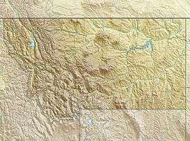 Jackson Glacier Location in Montana | |
| Type | Mountain glacier |
| Location | Glacier National Park, Glacier County, Montana, U.S. |
| Coordinates | 48°35′55″N 113°42′04″W / 48.59861°N 113.70111°WCoordinates: 48°35′55″N 113°42′04″W / 48.59861°N 113.70111°W[1] |
| Area | 250 acres (1.0 km2) in 2005[2] |
| Length | 0.7 miles (1.1 km) |
| Terminus | Bare rock |
| Status | Retreating |
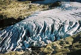
Jackson Glacier is approximately the seventh largest of the remaining 25 glaciers in Glacier National Park located in the US state of Montana.[2] A part of the largest grouping of glaciers in the park, Jackson Glacier rests on the north side of Mount Jackson.[3] The glacier was most recently measured in 2005 at 250 acres (1.0 km2), yet when first documented in 1850, the glacier also included the now separate Blackfoot Glacier and together, they covered 1,875 acres (7.59 km2). Between 1966 and 2005, Jackson Glacier lost almost a third of its acreage.[2] When the two glaciers were united prior to their separation sometime before 1929, they were known simply as Blackfoot Glacier.

In 1850, there were an estimated 150 glaciers in the park. Glaciologists have stated that by the year 2030, many if not all of the glaciers in the park may disappear completely.[4] Jackson and Blackfoot glaciers have been selected for monitoring by the U.S. Geological Survey's Glacier Monitoring Research program, which is researching changes to the mass balance of glaciers in and surrounding Glacier National Park. The glacier is being monitored using remote sensing equipment and repeat photography, where images of the glacier are taken from identical locations periodically.[5] Jackson Glacier is one of the easiest of the park's glaciers to observe, and is located south of the Going-to-the-Sun Road on the east side of the Continental Divide, upper St. Mary Valley.

See also
References
- ↑ "Jackson Glacier". Geographic Names Information System. United States Geological Survey. Retrieved 2012-08-12.
- 1 2 3 "Retreat of Glaciers in Glacier National Park" (pdf). United States Geological Survey. 2010. Retrieved 2011-11-04.
- ↑ Mount Jackson, MT (Map). Topoquest (USGS Quads). Retrieved 2011-11-04.
- ↑ Myrna, H.; P. Hall; Daniel B. Fagre (February 2003). "Modeled Climate-Induced Glacier Change in Glacier National Park, 1850–2100" (pdf). BioScience. 52 (2): 131–140. doi:10.1641/0006-3568(2003)053[0131:mcigci]2.0.co;2. Retrieved 2011-11-04.
- ↑ "Monitoring and Assessing Glacier Changes and Their Associated Hydrologic and Ecologic Effects in Glacier National Park". U.S. Geological Survey. Retrieved 2011-11-04.