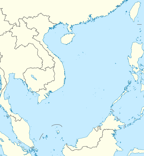
Luconia Shoals
| Disputed island Other names: Gugusan Beting Raja Jarum/ Gugusan Beting Patinggi Ali Beikang Ansha/ Nankang Ansha 北康暗沙/ 南康暗沙 | |
|---|---|
| Geography | |
 Luconia Shoals (South China Sea) | |
| Location | South China Sea |
| Coordinates | 05°36′N 112°36′E / 5.600°N 112.600°ECoordinates: 05°36′N 112°36′E / 5.600°N 112.600°E |
| Administered by | |
| Malaysia | |
| State | Sarawak |
| Claimed by | |
| Republic of China (Taiwan) | |
| People's Republic of China | |
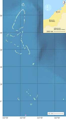
The Luconia Shoals, divided into the North and South Luconia Shoals, and sometimes known as the Luconia Reefs, are one of the largest and least-known reef complexes in the South China Sea.[1] Some geographers classify the shoals as part of the Spratly Islands.[2]
Location
The shoals lie around 100 kilometres (62 mi) off the Sarawak coast of Borneo, inside the exclusive economic zone of Malaysia and around 2,000 kilometres (1,200 mi) away from Mainland China. The shoals are southwest of the southernmost members of the Spratly Islands. Extending over an area of several thousand square kilometres, both the north and south groups of the shoals are permanently submerged at a depth of 5 to 40 metres (16 to 131 ft) below sea level, with the exception of Luconia Breakers. There are extensive oil and natural gas resources under the seabed in this area,[1] which is also home to various fishes including manta rays, wrasse and grouper.[3] The shoals was also the site where a 150-year-old British cargo vessel known as Viscount Melbourne sank.[4]
Features
| Feature | Chinese (Trad./Simp.) | Malaysian | Coordinates | Depth metres |
|---|---|---|---|---|
| North Luconia Shoals | Beikang Ansha (北康暗沙) | Gugusan Beting Raja Jarum | ||
| Friendship Shoal | Mengyi Ansha (盟誼暗沙/盟谊暗沙) | Beting Rentap | 5°57′N 112°32′E / 5.950°N 112.533°E | 8.2 |
| Hardie Reef1 | Haikang Ansha (海康暗沙) | Terumbu Asun | 5°56′N 112°31′E / 5.933°N 112.517°E | 5.1 |
| Aitken Reef1 | Yijing Jiao (義淨礁/义净礁) | Terumbu Datak Landih | 5°54′N 112°33′E / 5.900°N 112.550°E | 9.4 |
| Buck Reef1 | Faxian Ansha (法顯暗沙/法显暗沙) | Terumbu Linggir | 5°45′N 112°33′E / 5.750°N 112.550°E | 4.9 |
| Moody Reef | Kangxi Ansha (康西暗沙) | Terumbu Permaisuri | 5°38′N 112°22′E / 5.633°N 112.367°E | 7.3 |
| Seahorse Breakers | Nan'an Jiao (南安礁) | Hempasan Dang Ajar | 5°32′N 112°35′E / 5.533°N 112.583°E | 2 |
| Tripp Reef | Bei'an Jiao (北安礁) | Terumbu Litong | 5°39′N 112°32′E / 5.650°N 112.533°E | 3.7 |
| Hayes Reef | Nanping Jiao (南屏礁) | Terumbu Lang Ngindang | 5°22′N 112°38′E / 5.367°N 112.633°E | <0 |
| South Luconia Shoals | Nankang Ansha (南康暗沙) | Gugusan Beting Patinggi Ali | ||
| Stigant Reef | Hai'an Jiao (海安礁) | Terumbu Sahap | 5°02′N 112°30′E / 5.033°N 112.500°E | 4.6 |
| Connell Reef | Yinbo Ansha (隱波暗沙/隐波暗沙) | Terumbu Dato Talip | 5°06′N 112°34′E / 5.100°N 112.567°E | 1.8 |
| Herald Reef | Haining Jiao (海寧礁/海宁礁) | Terumbu Saji | 4°57′N 112°37′E / 4.950°N 112.617°E | 2 |
| Comus Shoal | Huanle Ansha (歡樂暗沙/欢乐暗沙) | Beting Merpati | 5°01′N 112°56′E / 5.017°N 112.933°E | 8.2 |
| Richmond Reef | Tanmen Jiao (潭門礁/潭门礁) | Terumbu Balingian | 5°04′N 112°43′E / 5.067°N 112.717°E | 3.6 |
| Luconia Breakers | Qiongtai Jiao (瓊台礁/琼台礁) | Hempasan Bentin | 5°1′23″N 112°38′13″E / 5.02306°N 112.63694°E | >0 |
| Sierra Blanca | Cheng Ping Jiao (澄平礁) | ... | 4°51′N 112°32′E / 4.850°N 112.533°E | <0 |
1) Hardie Reef, Aitken Reef and Buck Reef, from north to south, are part of an atoll which as a whole is named by the Chinese only: 盟谊南 or Méng yì nán, which would translate as Friendship South.
Source:[2]
Satellite Images
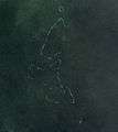 Landsat 7 image of North Luconia Shoals
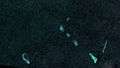
Territorial disputes
The Luconia shoals are administered by Malaysia, and is claimed by the Republic of China (Taiwan), the People's Republic of China.
Malaysia
The shoals are administered by Malaysia[5] and the Royal Malaysian Navy and Malaysian Maritime Enforcement Agency maintains a 24/7 presence in the area to monitor the shoals.[6] Malaysia's Fisheries Research Institute has conducted studies on the area since 2004.[7]
Malaysia organises an annual International Deep Sea Fishing Tournament on the shoals with participants departing from the Marina May in Miri and heading up to the area for 3 days. The participant who catches the biggest fish are proclaimed the winners of the tournament[8][9]
On 31 August 2015, amateur marine archaeologist Captain Hans Berekoven with his wife and a team of marine researchers as well Sarawak Museum curator went to the shoals to planting Malaysian flag. Berekoven said the move was important to warn China to back down and urging the Malaysian government to take a serious look into the matter because the site is also a maritime archaeological site of Viscount Melbourne where he was currently on a mission to gather relevant information relating to Sunda Shelf, a sunken site surrounding Southern Asia that could prove a lost civilisation of over 12,000 years old.[4]
China
In June 2015, Malaysian authorities detected China Coast Guard vessel entering the area, appears to be anchored at the shoals, about 150 kilometres north of Malaysian Borneo—well inside the approximately 400-kilometre exclusive economic zone claimed by Malaysia. The Chinese vessel has been warned to leave the area and is monitored closely by Royal Malaysian Navy. Malaysia lodged a protest over China's incursion into its waters,[10] as the republic’s ships had been in Malaysian waters for more than two years. In a recent statement by Minister in the Prime Minister’s Department Shahidan Kassim, "We have never received any official claims from them (China) and they said the island (Beting Patinggi Ali) belongs to them but the country is 400,000 kilometres (250,000 mi) away. We are taking diplomatic action but in whatever approach, they have to get out of our national waters". The Malaysian government had since sending diplomatic notes every week to protest against the intrusion.[11] There have also been reports that crews aboard the Chinese vessel threatened to shoot local Malaysian fishermen who attempted to fish in the area.[12]
On 31 March 2016, Malaysia summoned the Chinese ambassador in Kuala Lumpur to protest the presence of around 100 Chinese fishing boats at Luconia Shoals. Until March, the Malaysian government rarely rebuked China in public to avoid disturbances to Sino-Malay relations as Beijing emerges as the Malaysian economy's main investors. Kuala Lumpur has “consistently played down China’s activities in our territories”, said Wan Saiful Wan Jan, chief executive of the Institute for Democracy and Economic Affairs, a Malaysian think tank. “This could be to protect our commercial interest, or it could also be to avoid the public...realising how useless our defences are”.[13]
See also
- South China Sea Islands
- List of islands in the South China Sea
- Territorial disputes in the South China Sea
References
- 1 2 "Luconia Shoals". oceandots.com. Archived from the original on 24 July 2004. Retrieved 14 May 2012.
- 1 2 Hancox, David; Prescott, Victor (1995). A geographical description of the Spratly Islands and an account of hydrographic surveys amongst those islands (Maritime briefing). University of Durham, International Boundaries Research Unit. ISBN 978-1897643181. p.2
- ↑ "Preliminary Study on the Coral Reef Resources at Luconia Shoals, Miri, Sarawak" (PDF). Malaysian Fisheries Research Institute. December 2004. Retrieved 14 May 2012.
- 1 2 Cindy Lai (8 September 2015). "Marine archaeologist stamps Malaysia's mark on Luconia Shoals". The Borneo Post. Retrieved 8 September 2015.
- ↑ "WCT". Retrieved 9 June 2015.
- ↑ "The Borneo Post". Retrieved 9 June 2015.
- ↑ "Fisheries Research Institute" (PDF). Retrieved 9 June 2015.
- ↑ "Miri Anglers Club". Miri Anglers Club. Archived from the original on 16 April 2015. Retrieved 16 April 2015.
- ↑ "Miri Deep Sea fishing contest wants 'early birds' for logistics". The Borneo Post. 23 February 2015. Archived from the original on 16 April 2015. Retrieved 16 April 2015.
- ↑ "Malaysia Toughens Stance With Beijing Over South China Sea". Retrieved 8 June 2015.
- ↑ "Malaysia lodges diplomatic protest against intrusion at Beting Patinggi Ali". Bernama. The Rakyat Post. 15 August 2015. Retrieved 16 August 2015.
- ↑ "Presence of China Coast Guard ship at Luconia Shoals spooks local fishermen". The Borneo Post. 27 September 2015. Retrieved 28 September 2015.
- ↑ "Indonesia Blows Up 23 Foreign Fishing Boats to Send a Message". The Wall Street Journal. 5 April 2016. Retrieved 6 April 2016.
External links
- Map (Chinese)
- Tactical Pilotage Chart 1:250,000 Map Sheet L-11 A
- Sat image South Luconia Shoals complete
- Photo of Luconia Breakers (drying reef)