Luding County
| Luding County | |
|---|---|
| County | |
| Chinese transcription(s) | |
| • Characters | 泸定县 |
| • Pinyin | Lúdìng Xiàn |
|
Luding Bridge crossing the Dadu River | |
.png) Location in Sichuan | |
 Luding County Location in China | |
| Coordinates: 29°55′12″N 102°15′0″E / 29.92000°N 102.25000°ECoordinates: 29°55′12″N 102°15′0″E / 29.92000°N 102.25000°E | |
| Country | China |
| Province | Sichuan |
| Prefecture | Garzê |
| County seat | Luqiao Town (泸桥镇) |
| Area | |
| • Total | 2,165 km2 (836 sq mi) |
| Population (2004) | |
| • Total | 80,000 |
| • Density | 37/km2 (96/sq mi) |
| • Major nationalities |
Han - 84.86% Tibetan - 10.06% Yi - 4.4% |
| Time zone | China Standard (UTC+8) |
| Postal code | 626100 |
| Area code(s) | 0836 |
| Website | http://www.luding.gov.cn |
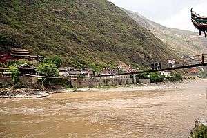
Luding County (Tibetan: ལྕགས་ཟམ།, Chagsam; Chinese: 泸定县; pinyin: Lúdìng Xiàn, Tibetan Jagsamka) is a part of the Garzê Tibetan Autonomous Prefecture in the Chinese Province of Sichuan. Luding County covers an area of 2,165 km² and has a population of approximately 80,000 (at the end of 2004). The census in the year 2000 recorded a population of 77,855.
Administrative divisions
Luding County contains four towns and eight townships:
- Luqiao Town (泸桥镇), 19,459 inhabitants (2000), seat of the county government;
- Lengqi Town (冷碛镇), 8,900 inhabitants (2000);
- Xinglong Town (兴隆镇), 9,522 inhabitants (2000);
- Moxi Town (磨西镇), 6,794 inhabitants (2000);
- Lan'an Township (岚安乡), 2,789 inhabitants (2000);
- Pengba Township (烹坝乡), 4,156 inhabitants (2000);
- Tianba Township (田坝乡), 4,124 inhabitants (2000);
- Chuni Township (杵坭乡), 2,966 inhabitants (2000);
- Jiajun Township (加郡乡), 3,873 inhabitants (2000);
- Dewei Township (德威乡), 4,602 inhabitants (2000);
- Xinxing Township (新兴乡), 4,568 inhabitants (2000);
- Detuo Township (得妥乡), 6,102 inhabitants (2000)
Ethnic Composition of the Population of Luding County (2000)
A Census in the year 2000 counted 77,855 inhabitants in total.
| Ethnic Group | Inhabitants | Portion |
|---|---|---|
| Han | 66,066 | 84.86% |
| Tibetan | 7,834 | 10.06% |
| Yi | 3,424 | 4.4% |
| Mongols | 253 | 0.32% |
| Others | 278 | 0.36% |
Transport
External links
| County-level divisions |   | |
|---|---|---|
| Towns and villages |
| |
| Geography | ||
| Landmarks | ||
This article is issued from Wikipedia - version of the 1/19/2015. The text is available under the Creative Commons Attribution/Share Alike but additional terms may apply for the media files.