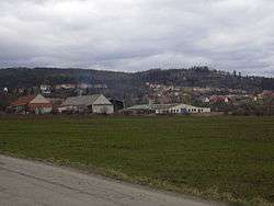
Luleč
| Luleč | |||
|---|---|---|---|
| Municipality | |||
 | |||
| |||
 Luleč | |||
| Coordinates: 49°15′23″N 16°55′44″E / 49.25639°N 16.92889°ECoordinates: 49°15′23″N 16°55′44″E / 49.25639°N 16.92889°E | |||
| Country |
| ||
| Region | South Moravian | ||
| District | Vyškov | ||
| Area | |||
| • Total | 11.96 km2 (4.62 sq mi) | ||
| Elevation | 302 m (991 ft) | ||
| Population (1.1.2012) | |||
| • Total | 835 | ||
| • Density | 70/km2 (180/sq mi) | ||
| Postal code | 683 03 | ||
| Website | http://www.lulec.eu/ | ||


Luleč is a village and municipality (obec) in Vyškov District in the South Moravian Region of the Czech Republic.
The municipality covers an area of 11.96 square kilometres (4.62 sq mi), and has a population of 775 (as at 28 August 2006).
Luleč lies approximately 5 kilometres (3 mi) west of Vyškov, 24 km (15 mi) east of Brno, and 203 km (126 mi) south-east of Prague.
References
| Wikimedia Commons has media related to Luleč. |
This article is issued from Wikipedia - version of the 4/7/2016. The text is available under the Creative Commons Attribution/Share Alike but additional terms may apply for the media files.