M-211 (Michigan highway)
| ||||
|---|---|---|---|---|
|
M-211 highlighted in red | ||||
| Route information | ||||
| Maintained by MDOT | ||||
| Length: | 5.147 mi[1] (8.283 km) | |||
| Existed: | 1934[2][3] – present | |||
| Major junctions | ||||
| South end: |
| |||
| North end: | Onaway State Park near Onaway | |||
| Location | ||||
| Counties: | Presque Isle | |||
| Highway system | ||||
| ||||

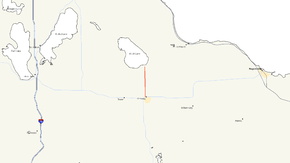
M-211 is a state trunkline highway in the Lower Peninsula (LP) of Michigan that connects the community of Onaway with Onaway State Park. The highway runs through farmland and forests along the 5.174-mile (8.327 km) route to the park. The trunkline was originally designated M-95 from 1919 until 1934. In that year, the designation was moved to a different highway in the Upper Peninsula (UP), and the state park connector was given the current number. The highway was last changed by 1960 when paving was completed.
Route description
M-211 is a two-lane highway that starts at M-68 in downtown Onaway. The trunkline runs north out of town on Main Street past business and residences. It crosses the North Eastern State Trail and passes the Leo E. Getz County Airport north of town. M-211 enters an area of farmland north of the airport. As it continues north and approaches Onaway State Park, the terrain transitions to forest land. M-211 ends at ythe intersection with Bonz Beach Highway in front of the state park gate. All of M-211 is undivided highway.[4][5]
Like other state highways in Michigan, M-211 is maintained by the Michigan Department of Transportation (MDOT). In 2010, the department's traffic surveys showed that on average, 1,429 vehicles used the highway in the city of Onaway and 1,254 vehicles did so north of the city line to the state park.[6] No section of M-211 is listed on the National Highway System,[7] a network of roads important to the country's economy, defense, and mobility.[8]
History
When the state highway system was initially signposted in 1919,[9] The highway that ran north from M-10 at Onaway toward Black Lake was numbered M-95.[10] By 1934, the highway was redesignated M-211 to free up the M-95 number. At the time, a highway in the UP was numbered M-45, but US Highway 45 was being extended into Michigan. The Michigan State Highway Department renumbered M-45 in the UP as M-95, and M-95 in the LP as M-211.[2][3] By the middle of 1960, all of the current M-211 was paved.[11] The highway has remained unchanged since.[4]
Major intersections
The entire highway is in Presque Isle County.
| Location | mi[1] | km | Destinations | Notes |
|---|---|---|---|---|
| Onaway | 0.000 | 0.000 | ||
| North Allis Township | 5.174 | 8.327 | Bonz Beach Highway | Onaway State Park gate |
| 1.000 mi = 1.609 km; 1.000 km = 0.621 mi | ||||
See also
 Michigan Highways portal
References
- 1 2 Michigan Department of Transportation & Michigan Center for Shared Solutions and Technology Partnerships (2009). MDOT Physical Reference Finder Application (Map). Michigan Department of Transportation. Retrieved September 29, 2010.
- 1 2 Michigan State Highway Department & Rand McNally (May 1, 1934). Official Michigan Highway Map (Map). [c. 1:850,000]. Lansing: Michigan State Highway Department. § E11. OCLC 12701143.
- 1 2 Michigan State Highway Department & Rand McNally (September 1, 1934). Official Michigan Highway Map (Map). [c. 1:850,000]. Lansing: Michigan State Highway Department. § E11. OCLC 12701143.
- 1 2 Michigan Department of Transportation (2012). Pure Michigan: State Transportation Map (Map). c. 1:975,000. Lansing: Michigan Department of Transportation. § E11. OCLC 42778335, 794857350.
- ↑ Google (September 28, 2010). "Overview Map of M-211" (Map). Google Maps. Google. Retrieved September 28, 2010.
- ↑ Bureau of Transportation Planning (2008). "Traffic Monitoring Information System". Michigan Department of Transportation. Retrieved June 12, 2012.
- ↑ Michigan Department of Transportation (April 23, 2006). National Highway System, Michigan (PDF) (Map). Scale not given. Lansing: Michigan Department of Transportation. Retrieved October 7, 2008.
- ↑ Natzke, Stefan; Neathery, Mike & Adderly, Kevin (June 20, 2012). "What is the National Highway System?". National Highway System. Federal Highway Administration. Retrieved July 1, 2012.
- ↑ "Michigan May Do Well Following Wisconsin's Road Marking System". The Grand Rapids Press. September 20, 1919. p. 10. OCLC 9975013.
- ↑ Michigan State Highway Department (July 1, 1919). State of Michigan (Map). Scale not given. Lansing: Michigan State Highway Department. Lower Peninsula sheet. OCLC 15607244.
- ↑ Michigan State Highway Department (1960). Official Highway Map (Map). [c. 1:918,720]. Lansing: Michigan State Highway Department. § E11. OCLC 12701120, 81552576. (Includes all changes through July 1, 1960)