M-212 (Michigan highway)
| ||||
|---|---|---|---|---|
| Center Street | ||||
|
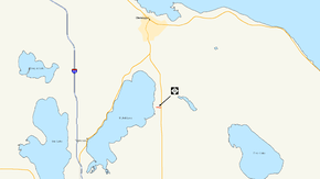
M-212 highlighted in red | ||||
| Route information | ||||
| Maintained by MDOT | ||||
| Length: | 0.732 mi[1] (1.178 km) | |||
| Existed: | December 29, 1937[2] – present | |||
| Major junctions | ||||
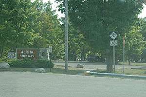
| West end: | Aloha State Park | |||
| East end: |
| |||
| Highway system | ||||
| ||||

M-212 is a state trunkline highway in the US state of Michigan. The highway was designated in order to provide access from M-33 to both the small community of Aloha on the eastern shore of Mullett Lake, as well as to Aloha State Park, where the highway ends. M-212 is the shortest signed state highway in Michigan, beating out the second shortest, M-239, which registers at 1.136 miles (1.828 km). M-212 even beats out Michigan's shortest signed business route, BUS M-32 in Hillman, which comes in at 0.738 miles (1.188 km), only about six-thousandths of a mile longer, or about 32 feet (9.8 m).[1]
M-212 was assigned on December 29, 1937, from the intersection with Second Street to an intersection with US Highway 23 (US 23). In 1940, the state of Michigan rerouted US 23 and replaced it with M-33.
Route description
M-212 begins at an intersection with Second Street and the Tromble Trail north of the entrance to Aloha State Park in the community of Aloha.[3][4] The community was originally a stop on the Detroit and Mackinac Railway that was named after a trip to Hawaii by the local sawmill owner.[5] Progressing eastward, M-212 intersects with Third Street and Fourth Street, both of which are just separated by woodlands and residences. To the north of the highway, there is all woodlands and residences. To the south, there are just a few residences. After a while, there is a large clearing, which gives way to a farm to the north and more residences to the south.[3][4] After the farm there is a large field and M-212 terminates at an intersection with M-33 in Aloha Township.[3][4]
History
The Michigan State Highway Department assigned M-212 to its current alignment in Aloha Township from what was then US 23 on December 29, 1937.[2] The route has remained mainly intact since its assignment.[3] Originally, US 23 ran along the highway at the eastern terminus of M-212,[6] but the highway department realigned the highway onto an alignment along the shore of Lake Huron in 1940; that year, the highway department replaced the former US 23 alignment with the designation of M-33,[7] which has remained there since.[3]
Major intersections
The entire highway is in Aloha Township, Cheboygan County.
| mi[1] | km | Destinations | Notes |
|---|---|---|---|
| 0.000 | 0.000 | Second Street | Aloha State Park entrance |
| 0.732 | 1.178 | ||
| 1.000 mi = 1.609 km; 1.000 km = 0.621 mi | |||
See also
 Michigan Highways portal
References
- 1 2 3 Michigan Department of Transportation & Michigan Center for Shared Solutions and Technology Partnerships (2009). MDOT Physical Reference Finder Application (Map). Michigan Department of Transportation. Retrieved January 25, 2008.
- 1 2 Michigan Department of Transportation (June 27, 1966). "Cheboygan County" (PDF) (Map). Right-of-Way File Application. Scale not given. Lansing: Michigan Department of Transportation. Sheet 63. Retrieved June 8, 2008.
- 1 2 3 4 5 Michigan Department of Transportation (2015). Pure Michigan: State Transportation Map (Map). c. 1:975,000. Lansing: Michigan Department of Transportation. § E11. OCLC 42778335, 900162490.
- 1 2 3 Google (June 8, 2008). "Aloha, MI" (Map). Google Maps. Google. Retrieved June 8, 2008.
- ↑ Romig, Walter (1986). Michigan Place Names. Detroit: Wayne State University Press. p. 20. ISBN 978-0-8143-1838-6 – via Google Books.
- ↑ Michigan State Highway Department (December 1, 1927). Official Highway Service Map (Map). [c. 1:810,000]. Lansing: Michigan State Highway Department. OCLC 12701195, 79754957.
- ↑ Michigan State Highway Department & Rand McNally (April 15, 1940). Official Michigan Highway Map (Map) (Spring ed.). [c. 1:850,000]. Lansing: Michigan State Highway Department. § E11. OCLC 12701143.
External links
| Wikimedia Commons has media related to M-212. |