Marker, Norway
| Marker kommune | |||
|---|---|---|---|
| Municipality | |||
 | |||
| |||
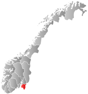
 Marker within Østfold | |||
| Coordinates: 59°30′40″N 11°37′42″E / 59.51111°N 11.62833°ECoordinates: 59°30′40″N 11°37′42″E / 59.51111°N 11.62833°E | |||
| Country | Norway | ||
| County | Østfold | ||
| District | Smaalenene | ||
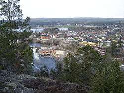
| Administrative centre | Ørje | ||
| Government | |||
| • Mayor (2003) | Kjersti Nythe Nilsen (Ap) | ||
| Area | |||
| • Total | 413 km2 (159 sq mi) | ||
| • Land | 368 km2 (142 sq mi) | ||
| Area rank | 235 in Norway | ||
| Population (2004) | |||
| • Total | 3,409 | ||
| • Rank | 250 in Norway | ||
| • Density | 9/km2 (20/sq mi) | ||
| • Change (10 years) | 2.0 % | ||
| Demonym(s) | Marking[1] | ||
| Time zone | CET (UTC+1) | ||
| • Summer (DST) | CEST (UTC+2) | ||
| ISO 3166 code | NO-0119 | ||
| Official language form | Bokmål | ||
| Website |
www | ||
|
| |||

Marker is a municipality in Østfold county, Norway. The administrative centre of the municipality is the village of Ørje. Marker was created as a new municipality on 1 January 1964 after the merger of the two old municipalities of Rødenes and Øymark.
The municipality borders on Aremark, Rakkestad, Eidsberg, and Rømskog municipalities in Østfold county, Aurskog-Høland municipality in Akershus county, and on Sweden. European route E18 goes through the municipality.
The biggest attractions in the municipality are Ørje Fortress and Basmo Fortress. Basmo Fortress lies on an isolated mountain outcropping between the lakes Rødenessjøen and Hemnessjøen in the northwestern part of the municipality.
General information
Name
The Norse form of the name was Markir which is the plural form of mǫrk f 'woodland, borderland' (see > March).
Coat-of-arms
The coat-of-arms is from modern times. They were granted on 16 April 1982. The arms show two white-colored trunk-hooks on a blue background. They are a type of hook, normally on a long pole, used to drive tree trunks through the rivers. The main economic activity in the municipality is forestry, hence the use of the hooks. The two hooks also represent the two villages (and former municipalities) of Rødenes and Øymark.[2]
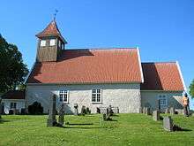
Rødenes church
Rødenes church (Rødenes kirke) is a Medieval era church in the Rødenes parish of Marker. Rødenes church belongs to Østre Borgesyssel deanery in the Diocese of Borg of the Church of Norway. The church is of Romanesque architecture style and dates from 1230. The church has a rectangular nave and lower and narrower choir. The pulpit of oak is from the 1600s. The altarpiece dates from the 1720s. The edifice is of stone and brick. The church is of long plan and has 240 number of seats. The church underwent extensive reconstruction in the years 1703-1709. Between 1949-1952, the church was restored. [3] [4]
Minorities
| Ancestry | Number |
|---|---|
| | 73 |
| | 34 |
| | 31 |
References
- ↑ "Navn på steder og personer: Innbyggjarnamn" (in Norwegian). Språkrådet. Retrieved 2015-12-01.
- ↑ Norske Kommunevåpen (1990). "Nye kommunevåbener i Norden". Retrieved 2008-12-15.
- ↑ "Rødenes kirke". Den Norkse Kirke. Retrieved October 1, 2016.
- ↑ "Østre Borgesyssel prosti". arkivportalen. Retrieved October 1, 2016.
- ↑ "Immigrants and Norwegian-born to immigrant parents, by immigration category, country background and percentages of the population". ssb.no. Retrieved 29 June 2015.
External links
-
 Media related to Marker at Wikimedia Commons
 -
 The dictionary definition of Marker at Wiktionary
 - Municipal fact sheet from Statistics Norway
-

Wikivoyage has a travel guide for Østfold. - Culture in Marker on the map (Norwegian)