Masfjorden
| Masfjorden kommune | |||
|---|---|---|---|
| Municipality | |||
 | |||
| |||
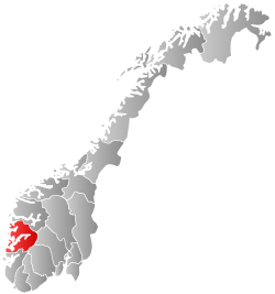
 Masfjorden within Hordaland | |||
| Coordinates: 60°50′18″N 05°26′55″E / 60.83833°N 5.44861°ECoordinates: 60°50′18″N 05°26′55″E / 60.83833°N 5.44861°E | |||
| Country | Norway | ||
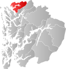
| County | Hordaland | ||
| District | Nordhordland | ||
| Administrative centre | Masfjordnes | ||
| Government | |||
| • Mayor (2011) | Karstein Totland (H) | ||
| Area | |||
| • Total | 556.07 km2 (214.70 sq mi) | ||
| • Land | 510.85 km2 (197.24 sq mi) | ||
| • Water | 45.22 km2 (17.46 sq mi) | ||
| Area rank | 191 in Norway | ||
| Population (2014) | |||
| • Total | 1,693 | ||
| • Rank | 349 in Norway | ||
| • Density | 3.3/km2 (9/sq mi) | ||
| • Change (10 years) | -1.1 % | ||
| Demonym(s) | Masfjording[1] | ||
| Time zone | CET (UTC+1) | ||
| • Summer (DST) | CEST (UTC+2) | ||
| ISO 3166 code | NO-1266 | ||
| Official language form | Nynorsk | ||
| Website |
www | ||
|
| |||
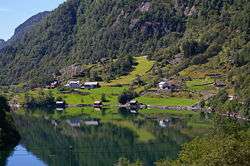
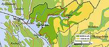
Masfjorden is a municipality in the northern part of Hordaland county in Norway. The municipality is located in the Nordhordland district of the county. The administrative centre of the municipality is the village of Masfjordnes. Other villages in the municipality include Frøyset, Hosteland, Matre, and Solheim.
The municipality is centered on the Masfjorden which almost divides the municipality completely into a north side and a south side. A cable ferry crosses the fjord from Masfjordnes to Duesund in the western part of the municipality. The Matre Hydroelectric Power Station is located in the eastern part of the municipality.
General information
The parish of Masfjorden was established as a municipality on 1 March 1879 when it was separated from the large municipality of Lindås. Masfjorden was the northern part of Lindås, and its initial population was 2,336. On 1 January 1964, the Einestrand, Eikebotn, and Kikallen area along the Austfjorden (population: 25) was transferred from Lindås to Masfjorden.[2]
Name
The municipality is named after the Masfjorden, the fjord which runs through it. The Old Norse form of the name was Matrsfjǫrðr. The first element is the genitive case of the old (uncompounded) name of the fjord: Matr. This name is derived from matr which means "food" - and the meaning of the fjord name is "the one full of food (fish)". The village of Matre lies at the inner end of the fjord, and that name has a similar origin.[3]
Coat-of-arms
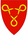
The coat-of-arms is from modern times. They were granted on 28 September 1990. The arms feature three gold heldrer, a traditional tool made of wood for fastening a rope around a load. They are meant to symbolize unity as well as the importance of forestry. Three of these objects appear in yellow and they are centered on a field of red.[4][5][6]
- See also: Coat of arms of Øyer
Churches
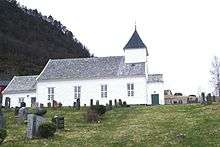
The Church of Norway has three parishes (sokn) within the municipality of Masfjorden. It is part of the Nordhordland deanery in the Diocese of Bjørgvin.
| Parish (Sokn) | Church Name | Location of the Church | Year Built |
|---|---|---|---|
| Frøyset | Frøyset Church | Frøyset | 1937 |
| Sandnes | Sandnes Church | Masfjordnes | 1845 |
| Solheim | Solheim Church | Solheim | 1881 |
Government
| Historical population | ||
|---|---|---|
| Year | Pop. | ±% |
| 1951 | 1,928 | — |
| 1960 | 1,987 | +3.1% |
| 1970 | 1,858 | −6.5% |
| 1980 | 1,915 | +3.1% |
| 1990 | 1,891 | −1.3% |
| 2000 | 1,774 | −6.2% |
| 2010 | 1,635 | −7.8% |
| 2014 | 1,693 | +3.5% |
| Source: Statistics Norway. | ||
All municipalities in Norway, including Masfjorden, are responsible for primary education (through 10th grade), outpatient health services, senior citizen services, unemployment and other social services, zoning, economic development, and municipal roads. The municipality is governed by a municipal council of elected representatives, which in turn elect a mayor.
Municipal council
The municipal council (Kommunestyre) of Masfjorden is made up of 17 representatives that are elected to every four years. For 2011–2015, the party breakdown is as follows:[7]
| Party Name | Name in Norwegian | Number of representatives | |
|---|---|---|---|
| Labour Party | Arbeiderpartiet | 3 | |
| Progress Party | Framstegspartiet | 2 | |
| Conservative Party | Høgre | 6 | |
| Christian Democratic Party | Kristelig Folkeparti | 2 | |
| Centre Party | Senterpartiet | 2 | |
| Liberal Party | Venstre | 2 | |
| Total number of members: | 17 | ||
Geography
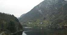
Masfjorden municipality lies to the east of the Fensfjorden and Austfjorden. The Masfjorden runs east to west bisecting the municipality. The eastern part has mountains and as one heads westward, the land levels out before reaching the fjord in the east.
The municipality lies along the northern border of Hordaland county, bordering Sogn og Fjordane county to the north. The municipalities of Gulen and Høyanger lie to the north, the municipality of Modalen to the east, and the municipality of Lindås lies to the south and west.
The European route E39 highway runs through eastern Masfjorden heading north and south. The 4.1-kilometre (2.5 mi) long Masfjord Tunnel and the 2.5-kilometre (1.6 mi) long Jernfjell Tunnel (and a few other tunnels) are part of the E39 highway which winds its way through some valleys in the mountainous eastern region of Masfjorden.
References
- ↑ "Navn på steder og personer: Innbyggjarnamn" (in Norwegian). Språkrådet. Retrieved 2015-12-01.
- ↑ Jukvam, Dag (1999). "Historisk oversikt over endringer i kommune- og fylkesinndelingen" (PDF) (in Norwegian). Statistisk sentralbyrå.
- ↑ Rygh, Oluf (1910). Norske gaardnavne: Søndre Bergenhus amt (in Norwegian) (11 ed.). Kristiania, Norge: W. C. Fabritius & sønners bogtrikkeri. p. 430.
- ↑ Engene, Jan Oskar (27 June 2002). "Masfjorden, Hordaland". Flags of the World. Retrieved 2008-09-22.
- ↑ "Masfjorden Kommunevåpen" (in Norwegian). Masfjorden Municipality. Retrieved 2008-09-22.
- ↑ "Civic heraldry of Norway - Norske Kommunevåpen". Heraldry of the World. Retrieved 2014-03-18.
- ↑ "Members of the local councils, by party/electoral lists and municipality" (in Norwegian). Statistics Norway. 2011.