Stord
| Stord kommune | |||
|---|---|---|---|
| Municipality | |||
|
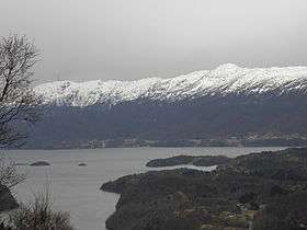
View of the town of Leirvik | |||
| |||
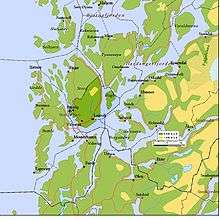
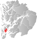 Stord within Hordaland | |||
| Coordinates: 59°48′29″N 05°27′59″E / 59.80806°N 5.46639°ECoordinates: 59°48′29″N 05°27′59″E / 59.80806°N 5.46639°E | |||
| Country | Norway | ||
| County | Hordaland | ||
| District | Sunnhordland | ||
| Administrative centre | Leirvik | ||
| Government | |||
| • Mayor (2015) | no:Harry Herstad (A) | ||
| Area | |||
| • Total | 143.7 km2 (55.5 sq mi) | ||
| • Land | 137.39 km2 (53.05 sq mi) | ||
| • Water | 6.31 km2 (2.44 sq mi) | ||
| Area rank | 358 in Norway | ||
| Population (2014) | |||
| • Total | 18,425 | ||
| • Rank | 61 in Norway | ||
| • Density | 134.1/km2 (347/sq mi) | ||
| • Change (10 years) | 12.3 % | ||
| Demonym(s) | Stordabu, Stording[1] | ||
| Time zone | CET (UTC+1) | ||
| • Summer (DST) | CEST (UTC+2) | ||
| ISO 3166 code | NO-1221 | ||
| Official language form | Nynorsk | ||
| Website |
www | ||
|
| |||

Stord is a municipality in Hordaland county, Norway. It is located in the traditional district of Sunnhordland. Stord is sometimes called "Norway in miniature" since it has such a variety of landscapes: coastline, fjords, forests, agricultural land, and mountain areas. The administrative centre of the municipality is the town of Leirvik, which is also the largest town in the municipality and the whole region of Sunnhordland. Leirvik was declared a town in 1997. Other population centres in the municipality include the large village of Sagvåg and the smaller villages of Litlabø and Grov.[2]
General information
The parish of Stordøen was established as a municipality on 1 January 1838 (see formannskapsdistrikt). IN 1863, the northern district of the municipality (population: 2,313) was separated to become the new municipality of Fitjar. On 15 May 1868, the southern district of Stordøen located on the mainland (population: 900) was separated to form the new municipality of Valestrand. On 1 January 1898, the southern part of the island of Huglo (population: 117) was transferred from the neighboring municipality of Fjelberg to Stord. On 1 January 1970, the small uninhabited part of the island of Stord along the Valvatnavågen that belonged to Bømlo was transferred to Stord municipality.[2][3]
Name
The municipality is named after the large island of Stord (Old Norse: Storð). The name is old and it was (and still is) used in Icelandic literature meaning "ground" or "earth". Before 1889, the name was written "Stordøen".[4]
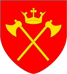
Coat-of-arms
The coat-of-arms is from modern times. They were granted on 19 June 1987. The arms shows a yellow twig of holly on a red background. The holly was chosen since it is a common tree in the municipality. The designer was Truls Nygaard.[5]
Churches
The Church of Norway has two parishes (sokn) within the municipality of Stord. It is part of the Sunnhordland deanery in the Diocese of Bjørgvin.
| Parish (Sokn) | Church Name | Location of the Church | Year Built |
|---|---|---|---|
| Stord | Stord Church | Leirvik | 1857 |
| Nysæter | Nysæter Church | Sagvåg | 1991 |
Geography
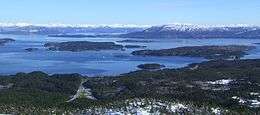
Stord is located on the southern half of the island of Stord (the northern part is part of Fitjar municipality). The municipality also includes the islands of Huglo Storstøya, Nautøya, and Føyno. The Hardangerfjorden runs along the southern border of the island municipality, separating it from the municipalities of Kvinnherad, Vindafjord, and Sveio. The Langenuen strait runs along the eastern side, separating it from Tysnes municipality. The Stokksundet and Digernessundet straits runs along the western border, separating it from the municipality of Bømlo. The mountain Mehammarsåto is the highest point in the municipality.
History
| Historical population | ||
|---|---|---|
| Year | Pop. | ±% |
| 1951 | 5,583 | — |
| 1961 | 7,766 | +39.1% |
| 1971 | 10,607 | +36.6% |
| 1981 | 13,007 | +22.6% |
| 1991 | 14,684 | +12.9% |
| 2001 | 16,241 | +10.6% |
| 2011 | 17,804 | +9.6% |
| 2014 | 18,425 | +3.5% |
| Source: Statistics Norway. | ||
The battle of Stord was fought on or by this island between the Norwegian king Hakon Haraldsson and the Danish king Harald "Bluetooth" Gormsson, supported by Hakon's brother's sons led by Harald "Greycloak" Eiriksson.
Economy
The 3 largest private employers in Stord municipality are: Kværner Stord AS, Wärtsilä Norway AS and Apply Leirvik AS. Together these three companies employ more than 3000 people.
Aker Stord, situated south of Leirvik on the peninsula of Eldøyane, is the largest yard in Norway. Aker Stord has built the biggest oil production platforms in the world, Gullfaks C and Troll.
Transport
An extensive tunnel and bridge system, the Triangle Link, connected Stord to the mainland on 27 December 2000 and to the neighboring island of Bømlo on 30 April 2001. The bridges involved are the Bømla Bridge and Stord Bridge and the tunnel is the Bømlafjord Tunnel. The airport in Stord is Stord Airport, Sørstokken, is located northwest of Sagvåg on the Sørstokken peninsula. On 10 October 2006, Atlantic Airways Flight 670 skidded off the runway at the airport. Four people died.[6][7]
Government
All municipalities in Norway, including Stord, are responsible for primary education (through 10th grade), outpatient health services, senior citizen services, unemployment and other social services, zoning, economic development, and municipal roads. The municipality is governed by a municipal council of elected representatives, which in turn elect a mayor.
Municipal council
The municipal council (Kommunestyre) of Stord is made up of 35 representatives that are elected to every four years. For 2011–2015, the party breakdown is as follows:[8]
| Party Name | Name in Norwegian | Number of representatives | |
|---|---|---|---|
| Labour Party | Arbeiderpartiet | 10 | |
| Progress Party | Framstegspartiet | 5 | |
| Conservative Party | Høgre | 9 | |
| Christian Democratic Party | Kristelig Folkeparti | 3 | |
| Centre Party | Senterpartiet | 3 | |
| Socialist Left Party | Sosialistisk Venstreparti | 2 | |
| Liberal Party | Venstre | 2 | |
| Local Lists | Lokale lister | 1 | |
| Total number of members: | 35 | ||
References
- ↑ "Navn på steder og personer: Innbyggjarnamn" (in Norwegian). Språkrådet. Retrieved 2015-12-01.
- 1 2 Store norske leksikon. "Stord – kommune" (in Norwegian). Retrieved 2015-02-06.
- ↑ Jukvam, Dag (1999). "Historisk oversikt over endringer i kommune- og fylkesinndelingen" (PDF) (in Norwegian). Statistisk sentralbyrå.
- ↑ Rygh, Oluf (1910). Norske gaardnavne: Søndre Bergenhus amt (in Norwegian) (11 ed.). Kristiania, Norge: W. C. Fabritius & sønners bogtrikkeri. p. 139.
- ↑ "Civic heraldry of Norway - Norske Kommunevåpen". Heraldry of the World.
- ↑ NTB. "Taleregistratoren fra Stord-flyet er lesbar" (in Norwegian). VG. Retrieved May 5, 2007.
- ↑ Aviation Safety Network. "Accident description British Aerospace BAe-146-200A". Aviation Safety Network. Retrieved May 5, 2007.
- ↑ "Members of the local councils, by party/electoral lists and municipality" (in Norwegian). Statistics Norway. 2011.