Maunaloa, Hawaii
| Maunaloa, Hawaii | |
|---|---|
| Census-designated place | |
 Location in Maui County and the state of Hawaii | |
| Coordinates: 21°8′11″N 157°12′51″W / 21.13639°N 157.21417°WCoordinates: 21°8′11″N 157°12′51″W / 21.13639°N 157.21417°W | |
| Country | United States |
| State | Hawaii |
| County | Maui |
| Area | |
| • Total | 0.7 sq mi (1.9 km2) |
| • Land | 0.7 sq mi (1.9 km2) |
| • Water | 0.0 sq mi (0.0 km2) |
| Elevation | 889 ft (271 m) |
| Population (2010) | |
| • Total | 376 |
| • Density | 510/sq mi (200/km2) |
| Time zone | Hawaii-Aleutian (UTC-10) |
| ZIP code | 96770 |
| Area code(s) | 808 |
| FIPS code | 15-50150 |
| GNIS feature ID | 0362274 |
Maunaloa or Mauna Loa[1] is a census-designated place (CDP) in Maui County, Hawaiʻi, United States, in the western part of the island of Molokai. The population was 376 at the 2010 census.[2]
Geography
Maunaloa is located at 21°8′11″N 157°12′51″W / 21.13639°N 157.21417°W (21.136464, -157.214029).[3]
According to the United States Census Bureau, the CDP has a total area of 0.73 square miles (1.9 km2), all of it land.[4]
Demographics
As of the census[5] of 2000, there were 230 people, 65 households, and 52 families residing in the CDP. The population density was 1,374.6 people per square mile (522.4/km²). There were 91 housing units at an average density of 543.9 per square mile (206.7/km²). The racial makeup of the CDP was 15.7% White, 0.3% African American, 18.7% Asian, 34.4% Pacific Islander, and 30.9% from two or more races. Hispanic or Latino of any race were 5.2% of the population.
There were 65 households out of which 50.8% had children under the age of 18 living with them, 56.9% were married couples living together, 18.5% had a female householder with no husband present, and 18.5% were non-families. 13.8% of all households were made up of individuals and 1.5% had someone living alone who was 65 years of age or older. The average household size was 3.54 and the average family size was 3.96.
In the CDP the population was spread out with 43.5% under the age of 18, 8.3% from 18 to 24, 25.2% from 25 to 44, 14.3% from 45 to 64, and 8.7% who were 65 years of age or older. The median age was 22 years. For every 100 females there were 109.1 males. For every 100 females age 18 and over, there were 94.0 males.
The median income for a household in the CDP was $22,232, and the median income for a family was $21,786. Males had a median income of $23,333 versus $20,625 for females. The per capita income for the CDP was $8,065. About 19.2% of families and 22.3% of the population were below the poverty line, including 29.7% of those under the age of eighteen and none of those sixty five or over.
Economy
The major employer in town until recently was Molokai Ranch, which owns about one third of the island's land. Molokai Ranch previously operated a small 22-room hotel, gas station, golf club and cattle-rearing business centered on the town. In April 2008 the company closed all of these businesses, stating that operations could not continue due to opposition from the community regarding its development plans for the island.[6] (See: Ke `Aupuni Lokahi)
References
- ↑ U.S. Geological Survey Geographic Names Information System: Maunaloa
- ↑ "Profile of General Population and Housing Characteristics: 2010 Demographic Profile Data (DP-1): Maunaloa CDP, Hawaii". U.S. Census Bureau, American Factfinder. Retrieved December 29, 2011.
- ↑ "US Gazetteer files: 2010, 2000, and 1990". United States Census Bureau. 2011-02-12. Retrieved 2011-04-23.
- ↑ "Geographic Identifiers: 2010 Demographic Profile Data (G001): Maunaloa CDP, Hawaii". U.S. Census Bureau, American Factfinder. Retrieved December 29, 2011.
- ↑ "American FactFinder". United States Census Bureau. Retrieved 2008-01-31.
- ↑ Molokai Ranch to quit island
Honolulu (capital) | ||
| Topics | ||
| Society | ||
| Main Islands | ||
| Northwestern Islands | ||
| Communities | ||
| Counties | ||
| Sovereignty Movement | ||
Islands, municipalities, and communities of Maui County, Hawaii, United States | ||
|---|---|---|
| CDPs | 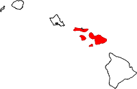 | |
| Unincorporated communities | ||
| Footnotes | ‡This populated place also has portions in an adjacent county or counties | |