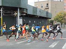
McGuinness Boulevard
Coordinates: 40°43′49″N 73°57′04″W / 40.73028°N 73.95117°W

McGuinness Boulevard is a boulevard in Greenpoint, a neighborhood in the New York City borough of Brooklyn. It runs between Interstate 278 to the south to the Pulaski Bridge in the north, which connects to Queens and Jackson Avenue (NY 25A). South of Driggs Avenue, it is called McGuinness Boulevard South.
A major street going through Greenpoint, it was formerly known as Oakland Street, which went from Driggs Avenue to the Newtown Creek. The road was widened considerably in 1954 after the Pulaski Bridge opened, replacing the Vernon Avenue Bridge to the west.[1] In 1964, it was renamed after former local Democratic alderman Peter McGuinness.[2]
The boulevard has a reputation as a dangerous speedway,[3] with three pedestrians and one cyclist dying on the boulevard between 2008 and 2013. It has consequently been compared to Queens Boulevard, Queens's "Boulevard of Death", due to the fatality rate, which is one of the highest among streets boroughwide. According to one study, at the intersection with Nassau Avenue alone, drivers violated traffic laws almost four times per minute.[4] As a result, the speed limit was lowered to 25 miles per hour from 30 mph in 2014 as part of Mayor Bill de Blasio's Vision Zero plan.[5][6] Even so, locals are requesting speed cameras, left-turn traffic lights, and pedestrian "countdown" signals.[7]
Other controversies have arisen on the street, including a planned homeless shelter at 400 McGuinness Boulevard, which was temporarily canceled due to neighborhood opposition.[8] Its opening was delayed to September 2012.[9]
References
- ↑ "Bridge Linking Greenpoint Section of Brooklyn and Long Island City Is Opened". The New York Times. September 11, 1954. p. 19. Retrieved 2009-08-15.
- ↑ "The Gowanus Lounge: Guest Post: Peter J. McGuinness, My Hero". Retrieved 10 September 2014.
- ↑ "After Fatal Hit-And-Run, McGuinness Blvd Infamy Increases: Gothamist". Gothamist. Retrieved 10 September 2014.
- ↑ "McGuinness is Brooklyn's killer boulevard, deaths and study show - NY Daily News". NY Daily News. Retrieved 10 September 2014.
- ↑ "McGuinness Boulevard Is NYC's Third 25 MPH Arterial Slow Zone - Streetsblog New York City". Retrieved 10 September 2014.
- ↑ "Greenpoint's McGuinness Boulevard Gets Slow Zone'd: Gothamist". Gothamist. Retrieved 10 September 2014.
- ↑ "Levin to DOT: Deadly McGuinness Blvd Needs Traffic Calming, Speed Cams - Streetsblog New York City". Retrieved 10 September 2014.
- ↑ "Local Opposition Kills Greenpoint Homeless Shelter Plan - Fine, Don't Gimme Shelter - Curbed NY". Curbed NY. Retrieved 10 September 2014.
- ↑ "New York Shitty Day Starter: 400 McGuinness Is Open For Business : newyorkshitty.com". newyorkshitty.com. Retrieved 10 September 2014.