Medicine Lake, Minnesota
| Medicine Lake, Minnesota | ||
|---|---|---|
| City | ||
|
Medicine Lake juts into the eponymous body of water; it consists of the large, curving peninsula. | ||
| ||
| Motto: "Where water meets the sky." | ||
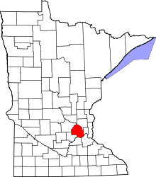
 Location of Medicine Lake within Hennepin County, Minnesota | ||
| Coordinates: 45°00′07″N 93°25′17″W / 45.00194°N 93.42139°WCoordinates: 45°00′07″N 93°25′17″W / 45.00194°N 93.42139°W | ||
| Country | United States | |
| State | Minnesota | |
| County | Hennepin | |
| Founded | 1887 | |
| Incorporated | 1944 | |
| Government | ||
| • Mayor | Gary Holter | |
| Area[1] | ||
| • City | 0.33 sq mi (0.85 km2) | |
| • Land | 0.18 sq mi (0.47 km2) | |
| • Water | 0.15 sq mi (0.39 km2) | |
| Elevation | 899 ft (274 m) | |
| Population (2010)[2] | ||
| • City | 371 | |
| • Estimate (2012[3]) | 379 | |
| • Density | 2,061.1/sq mi (795.8/km2) | |
| • Metro | 3,279,833 | |
| Time zone | Central (CST) (UTC-6) | |
| • Summer (DST) | CDT (UTC-5) | |
| ZIP code | 55441 | |
| Area code(s) | 763 | |
| FIPS code | 27-41462[4] | |
| GNIS feature ID | 0647733[5] | |
| Website | medicinelake.govoffice.com | |


Medicine Lake is a city in Hennepin County, Minnesota, United States. The population was 371 at the 2010 census.[6] The city is located on a peninsula that juts into a lake of the same name.
Geography
According to the United States Census Bureau, the city has a total area of 0.33 square miles (0.85 km2), of which 0.18 square miles (0.47 km2) is land and 0.15 square miles (0.39 km2) is water.[1] The city is completely surrounded by the city of Plymouth, and forms a peninsula stretching into the lake that it is named after.
Minnesota State Highway 55 is 0.5 mile from the community.
Demographics
| Historical population | |||
|---|---|---|---|
| Census | Pop. | %± | |
| 1950 | 284 | — | |
| 1960 | 323 | 13.7% | |
| 1970 | 446 | 38.1% | |
| 1980 | 419 | −6.1% | |
| 1990 | 385 | −8.1% | |
| 2000 | 368 | −4.4% | |
| 2010 | 371 | 0.8% | |
| Est. 2015 | 374 | [7] | 0.8% |
2010 census
As of the census[2] of 2010, there were 371 people, 160 households, and 104 families residing in the city. The population density was 2,061.1 inhabitants per square mile (795.8/km2). There were 174 housing units at an average density of 966.7 per square mile (373.2/km2). The racial makeup of the city was 89.8% White, 4.3% African American, 1.3% Native American, 2.2% Asian, and 2.4% from two or more races. Hispanic or Latino of any race were 1.3% of the population.
There were 160 households of which 23.8% had children under the age of 18 living with them, 51.9% were married couples living together, 7.5% had a female householder with no husband present, 5.6% had a male householder with no wife present, and 35.0% were non-families. 28.1% of all households were made up of individuals and 8.2% had someone living alone who was 65 years of age or older. The average household size was 2.32 and the average family size was 2.88.
The median age in the city was 47.7 years. 21.6% of residents were under the age of 18; 4.3% were between the ages of 18 and 24; 19.4% were from 25 to 44; 39.4% were from 45 to 64; and 15.4% were 65 years of age or older. The gender makeup of the city was 52.3% male and 47.7% female.
2000 census
As of the census of 2000,[4] there were 368 people, 159 households, and 94 families residing in the city. The population density was 2,133.1 persons per square mile (835.8/km²). There were 170 housing units at an average density of 985.4 per square mile (386.1/km²). The racial makeup of the city was 95.38% White, 0.54% African American, 2.45% Asian, and 1.63% from two or more races. Hispanic or Latino of any race were 1.36% of the population. 23.9% were of German, 14.0% Norwegian, 13.7% Swedish, 6.4% Dutch, 6.1% English and 5.1% Polish ancestry.
There were 159 households out of which 25.2% had children under the age of 18 living with them, 54.1% were married couples living together, 3.8% had a female householder with no husband present, and 40.3% were non-families. 32.7% of all households were made up of individuals and 6.3% had someone living alone who was 65 years of age or older. The average household size was 2.31 and the average family size was 3.02.
In the city the population was spread out with 20.9% under the age of 18, 6.3% from 18 to 24, 29.9% from 25 to 44, 32.3% from 45 to 64, and 10.6% who were 65 years of age or older. The median age was 41 years. For every 100 females there were 103.3 males. For every 100 females age 18 and over, there were 104.9 males.
The median income for a household in the city was $70,750, and the median income for a family was $100,382. Males had a median income of $51,250 versus $37,125 for females. The per capita income for the city was $45,942. None of the families and 1.1% of the population were living below the poverty line, including no under eighteens and none of those over 64.
Notable people
- Terry Gilliam – American-born British screenwriter, film director, animator, actor and member of the Monty Python comedy troupe. His family moved to Medicine Lake soon after Gilliam was born in Minneapolis in 1940.[9]
References
- 1 2 "US Gazetteer files 2010". United States Census Bureau. Retrieved 2012-11-13.
- 1 2 "American FactFinder". United States Census Bureau. Retrieved 2012-11-13.
- ↑ "Population Estimates". United States Census Bureau. Retrieved 2013-05-28.
- 1 2 "American FactFinder". United States Census Bureau. Retrieved 2008-01-31.
- ↑ "US Board on Geographic Names". United States Geological Survey. 2007-10-25. Retrieved 2008-01-31.
- ↑ "2010 Census Redistricting Data (Public Law 94-171) Summary File". American FactFinder. U.S. Census Bureau, 2010 Census. Retrieved 23 April 2011.
- ↑ "Annual Estimates of the Resident Population for Incorporated Places: April 1, 2010 to July 1, 2015". Retrieved July 2, 2016.
- ↑ "Census of Population and Housing". Census.gov. Retrieved June 4, 2015.
- ↑ The Pythons: Autobiography by The Pythons. New York: St. Martin's. 2003. ISBN 0-312-31145-1.
External links
- City of Medicine Lake website
- U.S. Geological Survey Geographic Names Information System: Medicine Lake, Minnesota
Municipalities and communities of Hennepin County, Minnesota, United States | ||
|---|---|---|
| Cities |
|  |
| Unorganized territory | ||
| Footnotes | ‡This populated place also has portions in an adjacent county or counties | |