Memphis, Alabama
| Memphis, Alabama | |
|---|---|
| Town | |
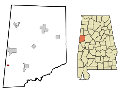 Location in Pickens County and the state of Alabama | |
| Coordinates: 33°8′1″N 88°17′49″W / 33.13361°N 88.29694°W | |
| Country | United States |
| State | Alabama |
| County | Pickens |
| Area | |
| • Total | 0.4 sq mi (1 km2) |
| • Land | 0.4 sq mi (1 km2) |
| • Water | 0 sq mi (0 km2) |
| Elevation | 167 ft (51 m) |
| Population (2010) | |
| • Total | 29 |
| • Density | 82.5/sq mi (33/km2) |
| Time zone | Central (CST) (UTC-6) |
| • Summer (DST) | CDT (UTC-5) |
| FIPS code | 01-48052 |
| GNIS feature ID | 0122652 |
Memphis, also known as Old Memphis, is a town in Pickens County, Alabama, United States. The population was 29 at the 2010 census, down from 33 in 2000. As long ago as 1850, it was listed as an incorporated community on the U.S. Census, but did not appear again on the rolls until its reincorporation in 1976.[1]
In 1981, it had the "dubious" distinction of being ranked the poorest incorporated community in the United States according to the U.S. Census. As of 1984, then-Mayor Jimmy Williams (b. c1922) stated the town received just $2,000 per year from state tax receipts and federal revenue-sharing funds and a sum total of $40 in the bank.[2] It was hoped the completion of the Tennessee-Tombigbee Waterway would help raise the standard of living for the town.
Geography
Memphis is located at 33°8′1″N 88°17′49″W / 33.13361°N 88.29694°W (33.133678, -88.297023).[3]
According to the U.S. Census Bureau, the town has a total area of 0.4 square miles (1.0 km2), all land.
Demographics
| Historical population | |||
|---|---|---|---|
| Census | Pop. | %± | |
| 1850 | 156 | — | |
| 1970 | 99 | — | |
| 1980 | 95 | −4.0% | |
| 1990 | 54 | −43.2% | |
| 2000 | 33 | −38.9% | |
| 2010 | 29 | −12.1% | |
| Est. 2015 | 28 | [4] | −3.4% |
| U.S. Decennial Census[5] 2013 Estimate[6] | |||
As of the 2010 United States Census, there were 29 people residing in the town. 100.0% were African American.
Gallery
Below are photographs taken as part of the Historic American Buildings Survey:
_ELEVATION_-_Charity_House%2C_State_Route_32_and_County_Route_1_vicinity%2C_Memphis%2C_Pickens_County%2C_AL_HABS_ALA%2C54-MEM%2C2-1.tif.jpg) Charity House
Charity House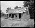 Will Boykin House
References
- ↑ 1830-2010 U.S. Censuses research on Pickens County, Alabama communities
- ↑ https://news.google.com/newspapers?nid=1817&dat=19840822&id=eII0AAAAIBAJ&sjid=zaUEAAAAIBAJ&pg=6741,6413358&hl=en
- ↑ "US Gazetteer files: 2010, 2000, and 1990". United States Census Bureau. 2011-02-12. Retrieved 2011-04-23.
- ↑ "Annual Estimates of the Resident Population for Incorporated Places: April 1, 2010 to July 1, 2015". Retrieved July 2, 2016.
- ↑ "U.S. Decennial Census". Census.gov. Retrieved June 6, 2013.
- ↑ "Annual Estimates of the Resident Population: April 1, 2010 to July 1, 2013". Retrieved June 3, 2014.
Coordinates: 33°08′01″N 88°17′49″W / 33.133678°N 88.297023°W
Municipalities and communities of Pickens County, Alabama, United States | ||
|---|---|---|
| Cities | 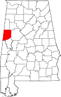 | |
| Towns | ||
| CDP | ||
| Unincorporated communities | ||