Merom, Indiana
| Merom, Indiana | |
|---|---|
| Town | |
|
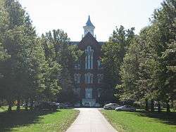
The former Union Christian College in Merom is listed on the National Register of Historic Places | |
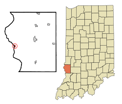 Location of Merom in the state of Indiana | |
| Coordinates: 39°3′25″N 87°34′0″W / 39.05694°N 87.56667°WCoordinates: 39°3′25″N 87°34′0″W / 39.05694°N 87.56667°W | |
| Country | United States |
| State | Indiana |
| County | Sullivan |
| Township | Gill |
| Area[1] | |
| • Total | 0.36 sq mi (0.93 km2) |
| • Land | 0.36 sq mi (0.93 km2) |
| • Water | 0 sq mi (0 km2) |
| Elevation[2] | 548 ft (167 m) |
| Population (2010)[3] | |
| • Total | 228 |
| • Estimate (2012[4]) | 227 |
| • Density | 633.3/sq mi (244.5/km2) |
| Time zone | Eastern (EST) (UTC-5) |
| • Summer (DST) | EDT (UTC-4) |
| ZIP code | 47861 |
| Area code(s) | 812 |
| FIPS code | 18-48474[5] |
| GNIS feature ID | 439023 |
| Website | http://meromindiana.org/ |
Merom is a town in Gill Township, Sullivan County, Indiana, United States. The population was 228 at the 2010 census. It is part of the Terre Haute Metropolitan Statistical Area.
History
The town's name commemorates the Battle of the Waters of Merom.[6] The Merom post office has been in operation since 1818.[7]
Geography
Merom is located at 39°3′25″N 87°34′0″W / 39.05694°N 87.56667°W (39.056950, -87.566573).[8]
According to the 2010 census, the town has a total area of 0.36 square miles (0.93 km2), all land.[1]
Demographics
| Historical population | |||
|---|---|---|---|
| Census | Pop. | %± | |
| 1860 | 234 | — | |
| 1870 | 426 | 82.1% | |
| 1880 | 407 | −4.5% | |
| 1890 | 412 | 1.2% | |
| 1900 | 478 | 16.0% | |
| 1910 | 521 | 9.0% | |
| 1920 | 503 | −3.5% | |
| 1930 | 397 | −21.1% | |
| 1940 | 499 | 25.7% | |
| 1950 | 374 | −25.1% | |
| 1960 | 352 | −5.9% | |
| 1970 | 305 | −13.4% | |
| 1980 | 360 | 18.0% | |
| 1990 | 257 | −28.6% | |
| 2000 | 294 | 14.4% | |
| 2010 | 228 | −22.4% | |
| Est. 2015 | 225 | [9] | −1.3% |
2010 census
As of the census[3] of 2010, there were 228 people, 99 households, and 59 families residing in the town. The population density was 633.3 inhabitants per square mile (244.5/km2). There were 123 housing units at an average density of 341.7 per square mile (131.9/km2). The racial makeup of the town was 100.0% White. Hispanic or Latino of any race were 0.4% of the population.
There were 99 households of which 36.4% had children under the age of 18 living with them, 42.4% were married couples living together, 13.1% had a female householder with no husband present, 4.0% had a male householder with no wife present, and 40.4% were non-families. 37.4% of all households were made up of individuals and 20.2% had someone living alone who was 65 years of age or older. The average household size was 2.30 and the average family size was 2.97.
The median age in the town was 39.4 years. 30.3% of residents were under the age of 18; 4.8% were between the ages of 18 and 24; 21.5% were from 25 to 44; 27.1% were from 45 to 64; and 16.2% were 65 years of age or older. The gender makeup of the town was 50.4% male and 49.6% female.
2000 census
As of the census[5] of 2000, there were 294 people, 108 households, and 81 families residing in the town. The population density was 813.7 people per square mile (315.3/km²). There were 135 housing units at an average density of 373.6 per square mile (144.8/km²). The racial makeup of the town was 98.30% White, 0.68% African American, and 1.02% from two or more races. Hispanic or Latino of any race were 0.68% of the population.
There were 108 households out of which 43.5% had children under the age of 18 living with them, 60.2% were married couples living together, 9.3% had a female householder with no husband present, and 25.0% were non-families. 21.3% of all households were made up of individuals and 11.1% had someone living alone who was 65 years of age or older. The average household size was 2.72 and the average family size was 3.12.
In the town the population was spread out with 32.0% under the age of 18, 3.4% from 18 to 24, 32.0% from 25 to 44, 19.0% from 45 to 64, and 13.6% who were 65 years of age or older. The median age was 36 years. For every 100 females there were 101.4 males. For every 100 females age 18 and over, there were 86.9 males.
The median income for a household in the town was $31,528, and the median income for a family was $33,333. Males had a median income of $30,250 versus $20,750 for females. The per capita income for the town was $13,087. About 13.5% of families and 14.5% of the population were below the poverty line, including 11.4% of those under the age of eighteen and 3.6% of those sixty five or over.
Geology
The Bluff Park in Merom is the site of the type locality of the Merom Sandstone.[11] The Merom Sandstone comprises approximately the upper 55 feet of the bluff's consolidated rock, and was deposited during the Pennsylvanian Period as part of the Mattoon Formation. The Merom Sandstone rests directly on top of the 2–3 feet thick Livingston Limestone (Bond Formation) at the Bluff Park. The irregular surface between the Livingston Limestone and the Merom Sandstone indicates the presence of a geological unconformity at the top of the Livingston Limestone.
Local attractions
Merom's two main attractions are the Bluff Park overlooking the Wabash River and the farm fields of Illinois and the Merom Conference Center, A retreat, conference center and summer camp of the Indiana-Kentucky Conference of the United Church of Christ. Nearby is Hoosier Energy's Merom Generating Station.
References
- 1 2 "Places: Indiana". 2010 Census Gazetteer Files. United States Census Bureau. Retrieved 2012-04-21. External link in
|work=(help) - ↑ "US Board on Geographic Names". United States Geological Survey. 2007-10-25. Retrieved 2008-01-31.
- 1 2 "American FactFinder". United States Census Bureau. Retrieved 2012-12-11.
- ↑ "Population Estimates". United States Census Bureau. Retrieved 2013-06-25.
- 1 2 "American FactFinder". United States Census Bureau. Retrieved 2008-01-31.
- ↑ Gannett, Henry (1905). The Origin of Certain Place Names in the United States. U.S. Government Printing Office. p. 206.
- ↑ "Sullivan County". Jim Forte Postal History. Retrieved August 29, 2016.
- ↑ "US Gazetteer files: 2010, 2000, and 1990". United States Census Bureau. 2011-02-12. Retrieved 2011-04-23.
- ↑ "Annual Estimates of the Resident Population for Incorporated Places: April 1, 2010 to July 1, 2015". Retrieved July 2, 2016.
- ↑ "Census of Population and Housing". Census.gov. Retrieved June 4, 2015.
- ↑ Willman, H. B.; et al. (1975). "Handbook of Illinois Stratigraphy". Bulletin 95: 261.
External links
![]() Media related to Merom, Indiana at Wikimedia Commons
Media related to Merom, Indiana at Wikimedia Commons
Municipalities and communities of Sullivan County, Indiana, United States | ||
|---|---|---|
| Cities | ||
| Towns | ||
| Townships | ||
| Unincorporated communities |
| |
| Ghost towns | ||
| Footnotes | ‡This populated place also has portions in an adjacent county or counties | |