Middlesex Downs, New Jersey
| Middlesex Downs, New Jersey | |
|---|---|
| Unincorporated community | |
|
Looking east along Dey Grove Road | |
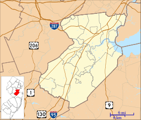 Middlesex Downs, New Jersey  Middlesex Downs, New Jersey  Middlesex Downs, New Jersey Location of Middlesex Downs in Middlesex County Inset: Location of county within the state of New Jersey | |
| Coordinates: 40°17′15″N 74°24′14″W / 40.28750°N 74.40389°WCoordinates: 40°17′15″N 74°24′14″W / 40.28750°N 74.40389°W | |
| Country |
|
| State |
|
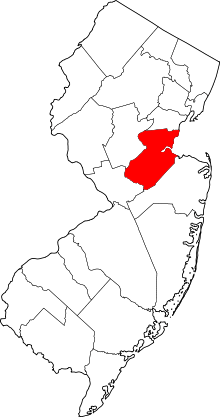
| County | Middlesex |
| Township | Monroe |
| Elevation[1] | 95 ft (29 m) |
| GNIS feature ID | 883005[1] |

Middlesex Downs is an unincorporated community located within Monroe Township in Middlesex County, New Jersey, United States. The wholly residential settlement contains small homes along Dey Grove Road and Bergen Mills Road with larger homes in developments towards the south. The township-owned James Monroe Memorial Park is also located in this settlement.[2] Much of the area to the north of Dey Grove Road consists of forest land but at one time this was planned to become a large planned community arranged in a street grid. The small property parcels and paper streets remain on township tax maps today.[3][4]
References
- 1 2 "Middlesex Downs". Geographic Names Information System. United States Geological Survey.
- ↑ Google (December 15, 2015). "Aerial view of Middlesex Downs" (Map). Google Maps. Google. Retrieved December 15, 2015.
- ↑ Zoning Map of Monroe Township Middlesex County New Jersey (Map). William M. Rimmey, Township Engineer. 1968. Retrieved December 15, 2015.
- ↑ State of NJ - Tax List Search (Map). State of New Jersey Transparency Center. Retrieved December 15, 2015.
This article is issued from Wikipedia - version of the 6/9/2016. The text is available under the Creative Commons Attribution/Share Alike but additional terms may apply for the media files.