Millboro, South Dakota
| Millboro, South Dakota | |
|---|---|
| Unincorporated community | |
 Millboro, South Dakota | |
| Coordinates: 43°04′23″N 99°58′08″W / 43.07306°N 99.96889°WCoordinates: 43°04′23″N 99°58′08″W / 43.07306°N 99.96889°W | |
| Country | United States |
| State | South Dakota |
| County | Tripp |
| Elevation | 2,218 ft (676 m) |
| Time zone | Central (CST) (UTC-6) |
| • Summer (DST) | CDT (UTC-5) |
| Area code(s) | 605 |
| GNIS feature ID | 1256469[1] |
Millboro is an unincorporated community in Tripp County, South Dakota, United States. Millboro is southwest of Colome.
Millboro was laid out in 1929, and named for a planned gristmill near the town site.[2]
References
- ↑ "US Board on Geographic Names". United States Geological Survey. 2007-10-25. Retrieved 2008-01-31.
- ↑ Federal Writers' Project (1940). South Dakota place-names, v.1-3. University of South Dakota. p. 50.
Municipalities and communities of Tripp County, South Dakota, United States | ||
|---|---|---|
| Cities | 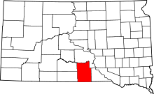 | |
| Town | ||
| CDP | ||
| Unincorporated communities | ||
| Indian reservation | ||
| Footnotes | ‡This populated place also has portions in an adjacent county or counties | |
This article is issued from Wikipedia - version of the 2/3/2016. The text is available under the Creative Commons Attribution/Share Alike but additional terms may apply for the media files.