Minnesota State Highway 26
| ||||
|---|---|---|---|---|
|
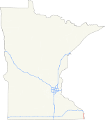
MN 26 highlighted in red | ||||
| Route information | ||||
| Maintained by Mn/DOT | ||||
| Length: | 21.121 mi[1] (33.991 km) | |||
| Existed: | 1933 – present | |||
| Major junctions | ||||
| South end: |
at the Minnesota — Iowa state line | |||
| North end: |
| |||
| Location | ||||
| Counties: | Houston | |||
| Highway system | ||||
| ||||

Minnesota State Highway 26 (MN 26) is a state highway in southeastern corner of the U.S. state of Minnesota. At 21 miles (34 km) in length, Highway 26 runs parallel to the Mississippi River and is a portion of the Great River Road. The route begins at the Iowa state line where it continues as Iowa Highway 26 and ends at an intersection with Minnesota State Highway 16, south of La Crescent.
Route description
State Highway 26 serves as a north–south route in southeast Minnesota between La Crescent, MN and Lansing, IA. The route follows a scenic path along the Mississippi River; as such, it makes up a section of the Great River Road. Because it is located in the Driftless Area, the Mississippi carved out a deep river valley, leaving high undulating bluffs which loom 300 feet (91 m) above the highway. Highway 26 is nestled between the base of the bluffs and the river channel.[2]
MN 26 begins at the Iowa state line near New Albin, Iowa, where Iowa Highway 26 crosses the border from the south. Immediately upon entering Minnesota, Highway 26 enters the Richard J. Dorer State Forest. For its first 7 miles (11 km), Highway 26 borders the backwaters of the Mississippi River, which lies 2 miles (3.2 km) to the east.[1] Near Reno, the river widens at the pool behind Lock and Dam No. 8.
Highway 26 continues north along the Mississippi River and the Iowa, Chicago and Eastern Railroad line towards Brownsville. North of Brownsville, Highway 26 begins to turn inland away from the river. Six miles (9.7 km) north of Brownsville, Highway 26 ends at a T intersection with Minnesota State Highway 16, near the Root River and the city of La Crescent.[1]
History
State Highway 26 was designated along unmarked Legislative Route 198 in 1933.[3] It originally connected Iowa Highway 182 and old U.S. Highway 16.[4] In 1980, U.S. 16 became Minnesota State Highway 16; and Iowa Highway 182 became Iowa Highway 26.
In August 2007, parts of Highway 26 were washed away by flooding or covered by landslides caused by unusually heavy rains.[5] Between 10–15 inches (25–38 cm) of rain fell over a two-day period.[6]
Major intersections
The entire route is in Houston County.
| Location | mi[1] | km | Destinations | Notes | |
|---|---|---|---|---|---|
| New Albin, Iowa | 0.000 | 0.000 | |||
| Reno | 6.234 | 10.033 | Old MN 249 | ||
| La Crescent Township | 21.121 | 33.991 | |||
| 1.000 mi = 1.609 km; 1.000 km = 0.621 mi | |||||
References
- 1 2 3 4 "Statewide Trunk Logpoint Listing" (PDF). Minnesota Department of Transportation. Retrieved 5 December 2016.
- ↑ Microsoft Research Maps (July 1, 1995). "7 km SW of La Crosse, Wisconsin, United States". Retrieved April 19, 2010.
- ↑ Minnesota Office of the Revisor of Statutes (2009). "§161.115 Additional Trunk Highways". 2009 Minnesota Statutes. Retrieved April 19, 2010.
- ↑ Thibodeau, William A. (1938). The ALA Green Book (1938–39 ed.). Automobile Legal Association.
- ↑ Rosenkrans, Nolan (September 2, 2008). "Are we to blame? A year after the floods, ways to lessen impact examined". Winona Daily news. Retrieved April 19, 2010.
- ↑ National Weather Service (May 23, 2008). "Historic Rainfall and Flooding Event of August 18-20, 2007". Retrieved April 19, 2010.