Mission Ridge, South Dakota
| Mission Ridge | |
|---|---|
| Unincorporated community | |
 Mission Ridge  Mission Ridge Location within the state of South Dakota | |
| Coordinates: 44°41′31″N 100°47′45″W / 44.69194°N 100.79583°WCoordinates: 44°41′31″N 100°47′45″W / 44.69194°N 100.79583°W | |
| Country | United States |
| State | South Dakota |
| County | Stanley |
| Elevation | 1,985 ft (605 m) |
| Time zone | Central (CST) (UTC-6) |
| • Summer (DST) | CDT (UTC-5) |
| ZIP codes | 57557 |
| GNIS feature ID | 1266866[1] |
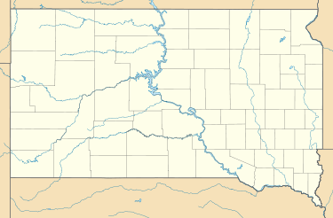
Mission Ridge is an unincorporated community in northern Stanley County, South Dakota, United States. It lies along Highway 1806 north of the city of Fort Pierre, the county seat of Stanley County.[2] Its elevation is 1,985 feet (605 m).[1] Mission Ridge has a post office with the ZIP code of 57557.[3]
The community was named for the elevated town site near Mission Creek.[4]
References
- 1 2 "Mission Ridge, South Dakota". Geographic Names Information System. United States Geological Survey. Retrieved 2008-03-04.
- ↑ Rand McNally. The Road Atlas '05. Chicago: Rand McNally, 2005, p. 93.
- ↑ Zip Code Lookup
- ↑ Federal Writers' Project (1940). South Dakota place-names, v.1-3. University of South Dakota. p. 50.
Municipalities and communities of Stanley County, South Dakota, United States | ||
|---|---|---|
| City | 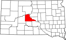 | |
| Unincorporated communities | ||
| Indian reservations | ||
| Ghost towns | ||
| Footnotes | ‡This populated place also has portions in an adjacent county or counties | |
This article is issued from Wikipedia - version of the 7/31/2016. The text is available under the Creative Commons Attribution/Share Alike but additional terms may apply for the media files.