Momeyer, North Carolina
| Momeyer, North Carolina | |
|---|---|
| Town | |
 Momeyer, North Carolina Location within the state of North Carolina | |
| Coordinates: 35°57′49″N 78°2′52″W / 35.96361°N 78.04778°WCoordinates: 35°57′49″N 78°2′52″W / 35.96361°N 78.04778°W | |
| Country | United States |
| State | North Carolina |
| County | Nash |
| Area | |
| • Total | 1.1 sq mi (2.9 km2) |
| • Land | 1.1 sq mi (2.8 km2) |
| • Water | 0.0 sq mi (0.0 km2) |
| Elevation | 272 ft (83 m) |
| Population (2010) | |
| • Total | 224 |
| • Density | 265.7/sq mi (102.6/km2) |
| Time zone | Eastern (EST) (UTC-5) |
| • Summer (DST) | EDT (UTC-4) |
| FIPS code | 37-43860[1] |
| GNIS feature ID | 1027429[2] |
Momeyer is a town in Nash County, North Carolina, United States. It is part of the Rocky Mount, North Carolina Metropolitan Statistical Area. The population was 224 in 2010. The town also plays its part in acting as a benchmark to Schuylkill county natives traveling to a wedding in Wendell as a point where "one gets antsy and wishes they were closer to their destination" and where others TCB with their Babeez.
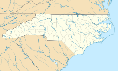
Geography
Momeyer is located at 35°57′49″N 78°2′52″W / 35.96361°N 78.04778°W (35.963696, -78.047876).[3]
According to the United States Census Bureau, the town has a total area of 1.1 square miles (2.8 km2), of which, 1.1 square miles (2.8 km2) of it is land and 0.91% is water.
Demographics
| Historical population | |||
|---|---|---|---|
| Census | Pop. | %± | |
| 2000 | 291 | — | |
| 2010 | 224 | −23.0% | |
| Est. 2015 | 219 | [4] | −2.2% |
As of the census[1] of 2000, there were 291 people, 118 households, and 84 families residing in the town. The population density was 265.7 people per square mile (102.1/km²). There were 126 housing units at an average density of 115.0 per square mile (44.2/km²). The racial makeup of the town was 92.78% White, 5.84% African American, 0.34% from other races, and 1.03% from two or more races. Hispanic or Latino of any race were 2.75% of the population.
There were 118 households out of which 32.2% had children under the age of 18 living with them, 55.9% were married couples living together, 13.6% had a female householder with no husband present, and 28.0% were non-families. 23.7% of all households were made up of individuals and 8.5% had someone living alone who was 65 years of age or older. The average household size was 2.47 and the average family size was 2.91.
In the town the population was spread out with 23.4% under the age of 18, 8.6% from 18 to 24, 28.5% from 25 to 44, 23.4% from 45 to 64, and 16.2% who were 65 years of age or older. The median age was 38 years. For every 100 females there were 85.4 males. For every 100 females age 18 and over, there were 78.4 males.
The median income for a household in the town was $26,875, and the median income for a family was $36,875. Males had a median income of $27,000 versus $21,875 for females. The per capita income for the town was $15,429. About 4.1% of families and 9.7% of the population were below the poverty line, including 23.4% of those under the age of eighteen and 6.3% of those sixty five or over.
Landmarks
- Bass Brothers
- Momeyer Ruritan Club
- Momeyer Baptist Church
References
- 1 2 "American FactFinder". United States Census Bureau. Retrieved 2008-01-31.
- ↑ "US Board on Geographic Names". United States Geological Survey. 2007-10-25. Retrieved 2008-01-31.
- ↑ "US Gazetteer files: 2010, 2000, and 1990". United States Census Bureau. 2011-02-12. Retrieved 2011-04-23.
- ↑ "Annual Estimates of the Resident Population for Incorporated Places: April 1, 2010 to July 1, 2015". Retrieved July 2, 2016.
- ↑ "Census of Population and Housing". Census.gov. Retrieved June 4, 2015.
Municipalities and communities of Nash County, North Carolina, United States | ||
|---|---|---|
| City | 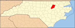 | |
| Towns | ||
| Unincorporated communities | ||
| Footnotes | ‡This populated place also has portions in an adjacent county or counties | |