Morvin, Alabama
| Morvin, Alabama | |
|---|---|
| Unincorporated community | |
|
Approaching Morvin on Alabama Highway 69 North | |
 Morvin, Alabama  Morvin, Alabama Location within the state of Alabama | |
| Coordinates: 31°59′6″N 87°59′34.8″W / 31.98500°N 87.993000°W | |
| Country | United States |
| State | Alabama |
| County | Clarke |
| Time zone | Central (CST) (UTC-6) |
| • Summer (DST) | CDT (UTC-5) |
| Area code(s) | 334 |

Morvin is an unincorporated community in Clarke County, Alabama, United States.[1]
Geography
Morvin is located at 31°59′06″N 87°59′35″W / 31.985°N 87.993°WCoordinates: 31°59′06″N 87°59′35″W / 31.985°N 87.993°W.[1] and is intersected by Alabama State Route 69 and Clarke County Highway 20.[2]

Sunset on Bashi Creek and the Tombigbee River at the Bashi Creek Public Use Area near Morvin.
References
- 1 2 "Morvin, Alabama". ePodunk Community Profiles. Retrieved 2008-01-16.
- ↑ "Morvin, AL". Google Maps. Google. Retrieved 2015-11-17.
Municipalities and communities of Clarke County, Alabama, United States | ||
|---|---|---|
| Cities | 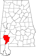 | |
| Towns | ||
| CDPs | ||
| Unincorporated communities | ||
| Ghost towns | ||
This article is issued from Wikipedia - version of the 9/21/2016. The text is available under the Creative Commons Attribution/Share Alike but additional terms may apply for the media files.