Mosby, Montana
| Mosby, Montana | |
|---|---|
| Unincorporated community | |
 Mosby, Montana Location within the state of Montana | |
| Coordinates: 46°59′32″N 107°53′1″W / 46.99222°N 107.88361°WCoordinates: 46°59′32″N 107°53′1″W / 46.99222°N 107.88361°W | |
| Country | United States |
| State | Montana |
| County | Garfield |
| Elevation | 2,513 ft (766 m) |
| Population (2000) | 17 |
| Time zone | Mountain (MST) (UTC-7) |
| • Summer (DST) | MDT (UTC-6) |
| ZIP codes | 59058 |
| GNIS feature ID | 774406 |
Mosby (also Half-Breed Crossing) is an unincorporated community in southwestern Garfield County, Montana, United States. It lies along Highway 200 southwest of the town of Jordan, the county seat of Garfield County. The town's population at the 2000 census was 17. [1] Its elevation is 2,513 feet (766 m).[2] Mosby had a post office that opened on 1904-06-29 was moved on 1983-02-18, and closed on 2015-07-30 [3] but the community still has a separate ZIP code of 59058.[4] As of 2015, there is an RV park where the gas station was. There was a gas station and repair shop open from 1950 to 1983.
Climate
According to the Köppen Climate Classification system, Mosby has a semi-arid climate, abbreviated "BSk" on climate maps.[5]
References
Municipalities and communities of Garfield County, Montana, United States | ||
|---|---|---|
| Town | 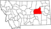 | |
| Unincorporated communities | ||