Mount Hebron, Greene County, Alabama
| Mount Hebron, Alabama | |
|---|---|
| Unincorporated community | |
 Mount Hebron  Mount Hebron | |
| Coordinates: 32°52′26″N 88°04′47″W / 32.87389°N 88.07972°WCoordinates: 32°52′26″N 88°04′47″W / 32.87389°N 88.07972°W | |
| Country | United States |
| State | Alabama |
| County | Greene |
| Elevation | 266 ft (81 m) |
| Time zone | Central (CST) (UTC-6) |
| • Summer (DST) | CDT (UTC-5) |
| Area code(s) | 205 |
| GNIS feature ID | 156744[1] |
Mount Hebron, also known as Hebron, is an unincorporated community in Greene County, Alabama, United States. Mount Hebron is located on Alabama State Route 39, 11.4 miles (18.3 km) west-northwest of Eutaw.
History
Mount Hebron was named for the mountain mentioned in the Bible.[2] A post office operated under the name Hebron from 1826 to 1833 and under the name Mount Hebron from 1837 to 1965.[3]
References
- ↑ "Mount Hebron". Geographic Names Information System. United States Geological Survey.
- ↑ Foscue, Virginia (1989). Place Names in Alabama. Tuscaloosa: The University of Alabama Press. p. 97. ISBN 0-8173-0410-X.
- ↑ "Greene County". Jim Forte Postal History. Retrieved 10 December 2015.
Municipalities and communities of Greene County, Alabama, United States | ||
|---|---|---|
| Cities | 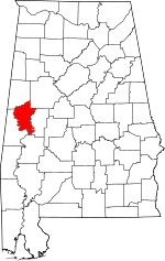 | |
| Towns | ||
| Unincorporated communities | ||
This article is issued from Wikipedia - version of the 10/28/2016. The text is available under the Creative Commons Attribution/Share Alike but additional terms may apply for the media files.