Mukdahan Province
| Mukdahan มุกดาหาร | |
|---|---|
| Province | |
|
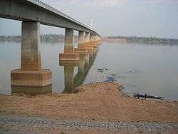
Second Thai–Lao Friendship Bridge, seen from Mukdahan | |
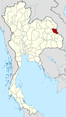 Map of Thailand highlighting Mukdahan Province | |
| Country |
|
| Capital | Mukdahan town |
| Government | |
| • Governor | Sorasit Ritsorakrai (since October 2015) |
| Area | |
| • Total | 4,339.8 km2 (1,675.6 sq mi) |
| Area rank | Ranked 52nd |
| Population (2014) | |
| • Total | 346,016[1] |
| • Rank | Ranked 65th |
| • Density rank | Ranked 61st |
| Time zone | ICT (UTC+7) |
| ISO 3166 code | TH-49 |
Mukdahan (Thai: มุกดาหาร, pronounced [múk.dāː.hǎːn]) is one of the northeastern provinces (changwat) of Thailand. Neighboring provinces are (from south clockwise) Amnat Charoen, Yasothon, Roi Et, Kalasin, Sakon Nakhon, and Nakhon Phanom. To the east it borders the Mekong River, across which lies Savannakhet Province of Laos.
Geography
The province is in the Mekong valley. In the west of the province are the Phu Phan mountains, which are covered with thick forests.
History
Lord Chandrasuriyawongse (เจ้าจันทรสุริยวงษ์) and his followers founded a settlement at Baan Luang Phonsim (บ้านหลวงโพนสิม) near the Thad Ing Hang Stupa (พระธาตุอิงฮัง) along the left banks of the Mekong River in Laos. Later, after some several decades, he died.
Lord Chanthakinnaree (เจ้าจันทกินรี), his son, succeeded him as ruler. Then, in B.E.2310, a huntsman crossed over the Mekong and arrived along the right side at the mouth of the stream Bang Muk (บังมุก), where he discovered a discarded realm complete with a monastery and seven sugar palms on the nearby riverbank. He found the area much better than the territories along the left side of the Mekong, and moreover at the mouth of the Bang Muk was an abundance of fish. Thus he headed back to report this to his ruler Lord Chanthakinnaree. Lord Chanthakinnaree led his followers across the Mekong to inspect the area and found that the area was indeed the remains of an ancient realm and in much better condition than any area along the left side of the Mekong. He led his people from Baan Luang Phonsim to establish a settlement on the right side of the Mekong at the mouth of the Bang Muk.
When he began to clear away the forests to make way for his resettlement of the realm, he found two Buddha images beneath a sacred fig tree on the banks of the Mekong. The larger of the two was bricks-and-mortar, while the smaller one was made of fine iron. He had a new monastery built at once in the vicinity of the old, abandoned temple on the banks of the Mekong, and named it Wat Sri Moungkhoun (วัดศรีมุงคุณ) (cognate to Sri Mongkol (ศรีมงคล) in Central Thai, meaning Temple of Serene Auspices). He also constructed a palatial manse in the vicinity of the temple where he enshrined both Buddha images in vihara. Later, the iron Buddha image (the smaller one) appeared to mysteriously reestablish itself beneath the fig tree where it had first been discovered and ultimately, after some three or four spectacles of this nature, began slowly sinking into the ground there until only the crown of the head could be seen. An alternate place of worship was built there to cover the site instead and the image itself was then named Phra Loup Lek (พระหลุบเหล็ก), or Venerable One of Ironmetal Who Shrouds Himself. Nowadays the site where Phra Loup Lek would submerge himself beneath the earth has been overtaken by the waters of the Mekong and washed away (presumably leaving only the shrine rescued and preserved at the front of the vihara at today's Wat Sri Mongkol South (วัดศรีมงคลใต้)).
As for the mason-and-mortar Buddha image enshrined in the vihara at the Sri Mongkol Temple, the inhabitants of the realm named it Phra Chao Ong Luang (พระเจ้าองค์หลวง), or Venerable Holy One, and made it the representative image of Wat Sri Mongkol, which itself was later renamed to Wat Sri Mongkol South; this Buddha image has been associated with the settlement and realm ever since.
During the rebuilding of the realm, at around midnight there were reports of a transparent or translucent object glittering and bright spotted emerging from the seven sugar palms on the banks of the Mekong River. It drifted in the air above the Mekong every night until near dawn when the crystal-like object would then float back into the seven trees from whence it came. Lord Chanthakinnaree named this auspicious omen Keo Mukdahan (แก้วมุกดาหาร) or the Pearlsmouth Crystal as he had founded his realm on the banks of the Mekong right where the mouth of the stream Bang Muk (or Pearlhaven) was located, in which people had discovered pearls (muk; มุก) in clams there. However, it is important to note that mukdahan can refer to most any semiprecious stone resembling the pearl having a grey dull color, and not necessarily the pearl oyster, Pinctada margaritifera. Lord Chanthakinnaree then renamed the realm to Mueang Mukdahan, as from the Fourth Month of the Year of the Pig, Year 1132 of the Chulasakarat (Minor Era), [Year 2313 of the Buddhasakarat (Buddhist Era or BE)] of the Buddhist calendar. The realm of Mukdahan at this stage covered both sides of the Mekong and reached the frontier lands of the Vietnamese (including the Laotian province of Savannakhet).
In B.E.2321, during the Thonburi Period when King Taksin the Great extended his armed forces into the area of the Mekong River, he ordered Phra Mahakasut Suek and Chao Phya Chakri to dispatch their troops to the banks of the Mekong in order to suppress and unify the lords of all the realms great and small there on both sides of the Mekong together under the reign of the Kingdom of Thonburi, declaring Lord Chanthakinnaree the Phya Chanthasrisuraja Uparaja Mandhaturaj (พระยาจันทรศรีสุราชอุปราชามันธาตุราช), the first Lord of the Realm of Mukdahan and thereby officially named the realm Mueang Mukdahan.
The city of Mukdahan was founded in 1770 by Lord Chanthakinnaree of Phonsim. It was originally administered from Udon Thani, but in 1907 it became a district (amphoe) of Nakhon Phanom Province. On September 27, 1982 Mukdahan was upgraded to provincial status.
In 2006, the Second Thai-Lao Friendship Bridge, from Mukdahan to Savannakhet, Laos was opened.
Symbols
The provincial seal shows the Prasart Song Nang Sathit Palace, in which an opal is displayed on a tray.
The provincial tree and flower is Ochna integerrima.
The provincial slogan is Skyscraping Ho Kaeo Tower, Phu Pha Thoep and Kaeng Kabao, eight ethnic minorities, famous sweet tamarind, large ancient kettledrum, origin of Lam Phaya, stunning view of the Mekong River, gateway to Indochina.
Administrative divisions
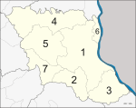
The province is subdivided into seven districts (amphoe). The districts are further subdivided into 53 subdistricts (tambon) and 493 villages (muban).
See also
References
- ↑ "Population of the Kingdom" (PDF). Department of Provincial Affairs (DOPA) Thailand (in Thai). 2014-12-31. Retrieved 19 Mar 2015.
External links
- TAT provincial page
- Website of the Province (Thai only)
 Mukdahan travel guide from Wikivoyage
 |
Sakon Nakhon Province | Nakhon Phanom Province | | |
| Kalasin Province | |
Savannakhet Province, | ||
| ||||
| | ||||
| Roi Et Province | Yasothon Province | Amnat Charoen Province |
Coordinates: 16°32′46″N 104°43′34″E / 16.54611°N 104.72611°E