Mutdapilly, Queensland
| Mutdapilly City of Ipswich, Queensland | |||||||||||||
|---|---|---|---|---|---|---|---|---|---|---|---|---|---|
 Cunningham Highway, 2015 | |||||||||||||
 Mutdapilly | |||||||||||||
| Coordinates | 27°44′32″S 152°39′51″E / 27.74222°S 152.66417°ECoordinates: 27°44′32″S 152°39′51″E / 27.74222°S 152.66417°E | ||||||||||||
| Established | 1827 | ||||||||||||
| Postcode(s) | 4307 | ||||||||||||
| LGA(s) | |||||||||||||
| State electorate(s) | |||||||||||||
| Federal Division(s) | |||||||||||||
| |||||||||||||
Mutdapilly is a locality in south-east Queensland, Australia. It is split between the local government areas of City of Ipswich and Scenic Rim Region.[1][2]
Mutdapilly is centrally divided by the north/south running Cunningham Highway. The western boundary follows Warrill Creek. There is one of fifteen air quality monitoring stations in the region located at Mutdapilly.[3] It was established in 1995.
History
The name Mutdapilly is believed to be a combination word from the Yuggera language (Yugarabul dialect) where mudtherri means sticky or muddy and pilly means gully.[1][2] The name was give by Captain Patrick Logan on 9 June 1827.[4]
Local resident, Mr Denman, donated 2 acres of land for a school. The Normanby State School and teacher's residence was opened on 27 April 1874; the first head teacher was John Stanfell Clowes who served at the school until 31 July 1876. The school was renamed Mutdapilly State School on 1 April 1968.[5][6][7]
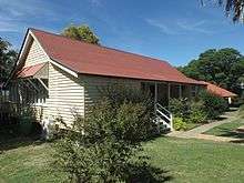
St Aidan's Church of England was built in Mutdapilly in 1921, designed by Charles Chauvel (the Australian filmmaker). The church closed in 1974 and the building is now used as a residence.[7][8]
Notable residents
- Charles Chauvel, early Australian filmmaker
References
- 1 2 "Mutdapilly (Ipswich City) (entry 46553)". Queensland Place Names. Queensland Government. Retrieved 27 February 2014.
- 1 2 "Mutdapilly (Scenic Rim Regional Council) (entry 45212)". Queensland Place Names. Queensland Government. Retrieved 27 February 2014.
- ↑ "South East Queensland". Air monitoring network stations. The State of Queensland. 9 May 2014. Retrieved 16 April 2015.
- ↑ "Indigenous Place Names" (PDF). Ipswich City Council. Retrieved 9 April 2015.
- ↑ "M". Opening and closing dates of Queensland schools. Queensland Government. Retrieved 27 February 2014.
- ↑ "Agency ID152, Mutdapilly State School". Queensland State Archives. Retrieved 27 February 2014.
- 1 2 "Harrisville & District" (PDF). Ipswich City Council. Retrieved 27 February 2014.
- ↑ Starr, Joan (1988), Moreton Shire Queensland : discovery and settlement, Southern Cross PR and Press Services, ISBN 978-0-9588021-0-9
Further reading
- Starr, Joan (1988), Moreton Shire Queensland : discovery and settlement, Southern Cross PR and Press Services, ISBN 978-0-9588021-0-9
External links
![]() Media related to Mutdapilly, Queensland at Wikimedia Commons
Media related to Mutdapilly, Queensland at Wikimedia Commons