Naval Air Station Oakland
| Naval Air Station Oakland | |
|---|---|
 | |
| IATA: none – ICAO: none | |
| Summary | |
| Airport type | Military |
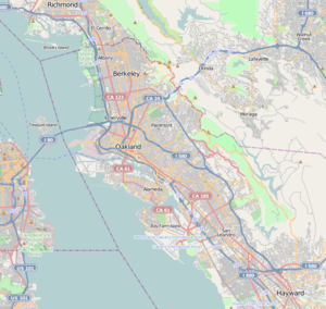
| Location | Oakland, California |
| Elevation AMSL | 9 ft / 3 m |
| Coordinates | 37°43′17″N 122°13′15″W / 37.72139°N 122.22083°WCoordinates: 37°43′17″N 122°13′15″W / 37.72139°N 122.22083°W |
| Maps | |
 FAA airport diagram | |
 NAS OAK Location within Oakland | |
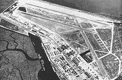
Naval Air Station Oakland is a former military airport located 4 NM (7.4 km; 4.6 mi) south of the central business district of Oakland, a city in Alameda County, California, United States. After its closure in the 1940s, it was reopened as Oakland International Airport.
History
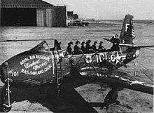
Advertising the Naval Air Reserve at NAS Oakland, 1949.
In 1943, the U.S. Armed Forces took over Oakland Airport and transformed it into an airlift base for military flights to the Pacific islands, ordering all scheduled service to move to San Francisco International Airport. After the war, airlines slowly returned to Oakland: Western Airlines began flights in 1946, and was followed by American Airlines, TWA, United and Pacific Southwest Airlines (PSA).
See also
| Wikimedia Commons has media related to Naval Air Station Oakland. |
- List of airports in the San Francisco Bay Area
- List of airports in California
- California World War II Army Airfields
References
External links
| Flying Training |
|  | ||||||
|---|---|---|---|---|---|---|---|---|
| Technical Training |
| |||||||

This article is issued from Wikipedia - version of the 11/11/2014. The text is available under the Creative Commons Attribution/Share Alike but additional terms may apply for the media files.