Napoleon, Indiana
| Napoleon, Indiana | |
|---|---|
| Town | |
|
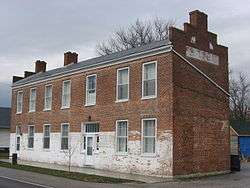
The Central House, a community landmark | |
 Location of Napoleon in the state of Indiana | |
| Coordinates: 39°12′15″N 85°19′43″W / 39.20417°N 85.32861°WCoordinates: 39°12′15″N 85°19′43″W / 39.20417°N 85.32861°W | |
| Country | United States |
| State | Indiana |
| County | Ripley |
| Township | Jackson |
| Area[1] | |
| • Total | 0.20 sq mi (0.52 km2) |
| • Land | 0.20 sq mi (0.52 km2) |
| • Water | 0 sq mi (0 km2) |
| Elevation | 965 ft (294 m) |
| Population (2010)[2] | |
| • Total | 234 |
| • Estimate (2012[3]) | 231 |
| • Density | 1,170.0/sq mi (451.7/km2) |
| Time zone | Eastern (EST) (UTC-5) |
| • Summer (DST) | EDT (UTC-4) |
| ZIP code | 47034 |
| Area code(s) | 812 |
| FIPS code | 18-52002[4] |
| GNIS feature ID | 0439935[5] |
Napoleon is a town in Jackson Township, Ripley County, Indiana, United States. The population was 234 at the 2010 census.
History
Napoleon was laid out in 1820.[6] The town was named in honor of Napoleon (1769–1821), a French military leader and emperor.[7] A post office has been in operation at Napoleon since 1821.[8]
The Central House and Elias Conwell House are listed on the National Register of Historic Places.[9]
Geography
Napoleon is located at 39°12′15″N 85°19′43″W / 39.20417°N 85.32861°W (39.204250, -85.328659).[10]
According to the 2010 census, Napoleon has a total area of 0.2 square miles (0.52 km2), all land.[1]
Demographics
| Historical population | |||
|---|---|---|---|
| Census | Pop. | %± | |
| 1880 | 250 | — | |
| 1960 | 290 | — | |
| 1970 | 282 | −2.8% | |
| 1980 | 246 | −12.8% | |
| 1990 | 238 | −3.3% | |
| 2000 | 238 | 0.0% | |
| 2010 | 234 | −1.7% | |
| Est. 2015 | 229 | [11] | −2.1% |
2010 census
As of the census[2] of 2010, there were 234 people, 111 households, and 66 families residing in the town. The population density was 1,170.0 inhabitants per square mile (451.7/km2). There were 126 housing units at an average density of 630.0 per square mile (243.2/km2). The racial makeup of the town was 100.0% White. Hispanic or Latino of any race were 1.3% of the population.
There were 111 households of which 23.4% had children under the age of 18 living with them, 44.1% were married couples living together, 7.2% had a female householder with no husband present, 8.1% had a male householder with no wife present, and 40.5% were non-families. 38.7% of all households were made up of individuals and 16.2% had someone living alone who was 65 years of age or older. The average household size was 2.11 and the average family size was 2.70.
The median age in the town was 45.3 years. 17.5% of residents were under the age of 18; 8.6% were between the ages of 18 and 24; 23% were from 25 to 44; 34.2% were from 45 to 64; and 16.7% were 65 years of age or older. The gender makeup of the town was 50.9% male and 49.1% female.
2000 census
As of the census[4] of 2000, there were 238 people, 93 households, and 74 families residing in the town. The population density was 1,266.1 people per square mile (483.6/km²). There were 103 housing units at an average density of 547.9 per square mile (209.3/km²). The racial makeup of the town was 98.32% White, 1.26% Native American, and 0.42% from two or more races. Hispanic or Latino of any race were 2.10% of the population.
There were 93 households out of which 34.4% had children under the age of 18 living with them, 62.4% were married couples living together, 14.0% had a female householder with no husband present, and 19.4% were non-families. 17.2% of all households were made up of individuals and 8.6% had someone living alone who was 65 years of age or older. The average household size was 2.56 and the average family size was 2.88.
In the town the population was spread out with 27.3% under the age of 18, 6.7% from 18 to 24, 31.1% from 25 to 44, 19.3% from 45 to 64, and 15.5% who were 65 years of age or older. The median age was 38 years. For every 100 females there were 110.6 males. For every 100 females age 18 and over, there were 98.9 males.
The median income for a household in the town was $39,844, and the median income for a family was $43,295. Males had a median income of $30,625 versus $28,750 for females. The per capita income for the town was $16,187. About 5.5% of families and 11.3% of the population were below the poverty line, including 21.3% of those under the age of eighteen and 4.3% of those sixty five or over.
External links
References
- 1 2 "G001 - Geographic Identifiers - 2010 Census Summary File 1". United States Census Bureau. Retrieved 2015-07-17.
- 1 2 "American FactFinder". United States Census Bureau. Retrieved 2012-12-11.
- ↑ "Population Estimates". United States Census Bureau. Retrieved 2013-06-25.
- 1 2 "American FactFinder". United States Census Bureau. Retrieved 2008-01-31.
- ↑ "US Board on Geographic Names". United States Geological Survey. 2007-10-25. Retrieved 2008-01-31.
- ↑ Places, Indiana (29 July 2011). A Visit to Osgood and Napoleon, Indiana: A Guide to Osgood and Napoleon in Southern Indiana. Mossy Feet Books. p. 7. ISBN 978-1-4657-2522-6.
- ↑ Baker, Ronald L. (October 1995). From Needmore to Prosperity: Hoosier Place Names in Folklore and History. Indiana University Press. p. 232. ISBN 978-0-253-32866-3.
...named for Napoleon Bonaparte.
- ↑ "Ripley County". Jim Forte Postal History. Retrieved 30 November 2015.
- ↑ National Park Service (2010-07-09). "National Register Information System". National Register of Historic Places. National Park Service.
- ↑ "US Gazetteer files: 2010, 2000, and 1990". United States Census Bureau. 2011-02-12. Retrieved 2011-04-23.
- ↑ "Annual Estimates of the Resident Population for Incorporated Places: April 1, 2010 to July 1, 2015". Retrieved July 2, 2016.
- ↑ "Census of Population and Housing". Census.gov. Retrieved June 4, 2015.
Municipalities and communities of Ripley County, Indiana, United States | ||
|---|---|---|
| City | ||
| Towns | ||
| Townships | ||
| Unincorporated communities |
| |
| Footnotes | ‡This populated place also has portions in an adjacent county or counties | |