Narakodur
| Narakodur నారాకోడూరు | |
|---|---|
| Village | |
|
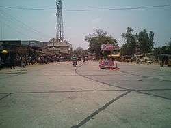
Narakoduru road junction | |
 Narakodur Location in Andhra Pradesh, India | |
| Coordinates: 16°13′35″N 80°30′53″E / 16.226258°N 80.514671°ECoordinates: 16°13′35″N 80°30′53″E / 16.226258°N 80.514671°E | |
| Country | India |
| State | Andhra Pradesh |
| District | Guntur |
| Mandal | Chebrolu |
| Government | |
| • Type | Panchayat raj |
| • Body | Narakodur gram panchayat |
| • Sarpanch | Jaladi Lakshmi Durga Bhanu Prasaad |
| Area[1] | |
| • Total | 12.09 km2 (4.67 sq mi) |
| Elevation[2] | 21 m (69 ft) |
| Population (2011)[3] | |
| • Total | 6,564 |
| • Density | 540/km2 (1,400/sq mi) |
| Languages | |
| • Official | Telugu |
| Time zone | IST (UTC+5:30) |
| PIN | 522 xxx |
Narakodur is a village in Guntur district of the Indian state of Andhra Pradesh. It is located in Chebrolu mandal of Tenali revenue division.[1]
Demographics
As of 2011 Census of India, Narakodur had a population of 6,564 with 1800 households. The total population constitute, 3,250 males and 3,314 females —a sex ratio of 1020 females per 1000 males. 575 children are in the age group of 0–6 years, of which 307 are boys and 268 are girls —a ratio of 873 per 1000. The average literacy rate stands at 72.32% with 4,331 literates, significantly higher than the state average of 67.41%.[3][4]
Government and politics
Narakodur gram panchayat is the local self-government of the village, constituted in the year 1952.[5][6] The panchayat has a total of 14 wards and each ward is represented by an elected ward member.[7] The ward members are headed by a sarpanch and the present sarpanch is Jaladi Lakshmi Durga Bhanu Prasaad.[8][9]
Transport
Narakodur is well connected by road to the nearby towns and cities. The State Highway 48 passes through Narakodur, that connects Guntur and Chirala.[10][11] Another road from the core road network is Tenali-Narakodur road, that connects the village with the city of Tenali.[12] Local transport include, city bus services operated by APSRTC from NTR bus station to Chebrolu.[13][14]
See also
References
- 1 2 "District Census Handbook – Guntur" (PDF). Census of India. p. 14,414. Retrieved 18 January 2015.
- ↑ "Elevation for Narakoduru". Veloroutes. Retrieved 17 October 2014.
- 1 2 "Census 2011". The Registrar General & Census Commissioner, India. Retrieved 17 October 2014.
- ↑ "Literacy of AP (Census 2011)" (PDF). Official Portal of Andhra Pradesh Government. p. 43. Retrieved 17 October 2014.
- ↑ "Layout page". areaprofiler.gov.in. Retrieved 2016-04-10.
- ↑ "Gram Panchayat Identification Codes" (PDF). Saakshar Bharat Mission. p. 99. Retrieved 5 July 2016.
- ↑ "Elected Representatives". National Panchayat Portal. Retrieved 6 May 2016.
- ↑ Social Science. Vk Publications. p. 117. ISBN 9788179732144.
- ↑ "List of elected Sarpanchas in Grampanchayat of Guntur district, 2013" (PDF). State Election Commission. Retrieved 5 June 2016.
- ↑ Samuel Jonathan, P (8 October 2015). "Nizampatnam backwaters beckon adventure geeks". The Hindu. Guntur. Retrieved 29 February 2016.
- ↑ "Road Maps". Roads and Buildings Department. Government of Andhra Pradesh. Retrieved 29 February 2016.
- ↑ ":: APRDC ::". Andhra Pradesh Road Development Corporation. Roads and Buildings Department. Retrieved 9 November 2016.
- ↑ "Guntur still awaits city RTC services – Times of India". The Times of India. 29 September 2014. Retrieved 18 June 2016.
- ↑ "New fleet of city buses in Guntur". The Hindu. Guntur. 20 August 2015. Retrieved 16 February 2016.
External links
| Wikimedia Commons has media related to Narakodur. |