National Register of Historic Places listings in Ascension Parish, Louisiana
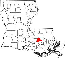
Location of Ascension Parish in Louisiana
This is a list of the National Register of Historic Places listings in Ascension Parish, Louisiana.
This is intended to be a complete list of the properties and districts on the National Register of Historic Places in Ascension Parish, Louisiana, United States. The locations of National Register properties and districts for which the latitude and longitude coordinates are included below, may be seen in a map.[1]
There are 18 properties and districts listed on the National Register in the parish. Another two properties were once listed but have been removed.
- This National Park Service list is complete through NPS recent listings posted December 16, 2016.[2]
Current listings
| [3] | Name on the Register[4] | Image | Date listed[5] | Location | City or town | Description |
|---|---|---|---|---|---|---|
| 1 | Ashland | .jpg) |
(#79001050) |
2 miles (3.2 km) south of Geismar on Louisiana Highway 75 30°10′34″N 90°59′56″W / 30.176111°N 90.998889°W |
Geismar | Also known as Belle Helene |
| 2 | Bocage | 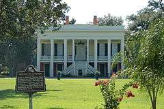 |
(#91000705) |
Louisiana Highway 942 south of Marchandville 30°07′24″N 90°57′19″W / 30.123333°N 90.955278°W |
Darrow | |
| 3 | Dixon House | 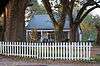 |
(#99000634) |
38127 Louisiana Highway 42 30°19′11″N 90°58′17″W / 30.319722°N 90.971389°W |
Prairieville | |
| 4 | Donaldsonville Historic District |  |
(#84001248) |
Roughly bounded by Bayou LaFourche, the Mississippi River levee, Jackson Ave., Marchand Dr., and Monroe and Church Sts. 30°06′09″N 90°59′15″W / 30.1025°N 90.9875°W |
Donaldsonville | |
| 5 | Evan Hall Slave Cabins | 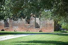 |
(#83000484) |
West of Donaldsonville 30°07′05″N 91°02′40″W / 30.118056°N 91.044444°W |
Donaldsonville | |
| 6 | Fort Butler |  |
(#99000183) |
Address Restricted |
Donaldsonville | Monument marks the location of a Civil War battle fought on the 28th of June 1863. |
| 7 | Helvetia Dependency | Upload image | (#92000570) |
Louisiana Highway 942 30°07′02″N 90°57′44″W / 30.117222°N 90.962222°W |
Darrow | |
| 8 | Hermitage | Upload image | (#73000859) |
1.75 miles east of Darrow on Louisiana Highway 942 30°06′55″N 90°57′45″W / 30.115278°N 90.9625°W |
Darrow | Built in 1812, originally L'Hermitage in French – named after Andrew Jackson's Tennessee home The Hermitage. General & Mrs. Jackson reportedly visited here during an 1820s trip to New Orleans. |
| 9 | The Houmas |  |
(#80001694) |
West of Burnside off Louisiana Highways 22 and 44 30°08′19″N 90°56′00″W / 30.138611°N 90.933333°W |
Burnside | Large Greek Revival mansion built in 1840, adjacent to an earlier Federal-style house and several other ancillary structures including octagonal garconnieres |
| 10 | Landry Tomb | 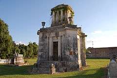 |
(#82002752) |
Ascension Catholic Church Cemetery, St. Vincent and Claiborne Sts. 30°05′57″N 90°59′09″W / 30.099167°N 90.985833°W |
Donaldsonville | Circa-1845 family monument attributed to architect James H. Dakin |
| 11 | Lemann Store |  |
(#82002753) |
314 Mississippi St. 30°06′22″N 90°59′14″W / 30.106111°N 90.987222°W |
Donaldsonville | |
| 12 | Mulberry Grove | 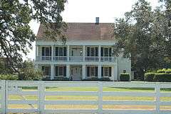 |
(#93001118) |
Louisiana Highway 405, 7 miles east-northeast of its junction with Louisiana Highway 1 30°11′34″N 91°02′10″W / 30.192778°N 91.036111°W |
White Castle | |
| 13 | Palo Alto Dependency | 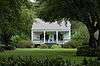 |
(#92000579) |
Louisiana Highway 944 30°05′28″N 91°01′57″W / 30.091111°N 91.0325°W |
Donaldsonville | |
| 14 | Palo Alto Plantation | 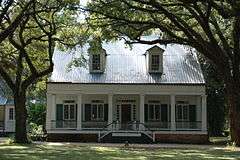 |
(#77000665) |
West of Donaldsonville on Louisiana Highway 1 30°05′28″N 91°01′52″W / 30.091111°N 91.031111°W |
Donaldsonville | |
| 15 | Rome House | 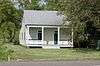 |
(#90000323) |
Louisiana Highway 1 at Delany Ln. 30°06′30″N 91°01′11″W / 30.108333°N 91.019722°W |
Smoke Bend | |
| 16 | St. Emma | 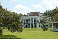 |
(#80001695) |
South of Donaldsonville 30°05′02″N 91°01′50″W / 30.083889°N 91.030556°W |
Donaldsonville | |
| 17 | Tezcuco | 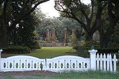 |
(#83000485) |
South of Burnside on River Rd. 30°06′57″N 90°54′38″W / 30.115833°N 90.910556°W |
Burnside | Completely destroyed by fire in May 2002[6] |
| 18 | Robert Penn Warren House | 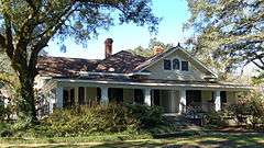 |
(#92001732) |
16381 Old Jefferson Highway 30°18′29″N 90°58′25″W / 30.308056°N 90.973611°W |
Prairieville | Also known as Twin Oaks |
Former listings
| [3] | Name on the Register | Image | Date listed | Date removed | Location | City or town | Summary |
|---|---|---|---|---|---|---|---|
| 1 | Kraemer House | Upload image | (#84001250) | Off U.S. Route 61 30°17′53″N 90°57′44″W / 30.298056°N 90.962222°W |
Prairieville | ||
| 2 | St. Joseph's School |  |
(#88002651) | Louisiana Highways 22 and 44 30°08′59″N 90°55′23″W / 30.149722°N 90.923056°W |
Burnside |
See also
| Wikimedia Commons has media related to National Register of Historic Places in Ascension Parish, Louisiana. |
- List of National Historic Landmarks in Louisiana
- National Register of Historic Places listings in Louisiana
References
- ↑ The latitude and longitude information provided in this table was derived originally from the National Register Information System, which has been found to be fairly accurate for about 99% of listings. For about 1% of NRIS original coordinates, experience has shown that one or both coordinates are typos or otherwise extremely far off; some corrections may have been made. A more subtle problem causes many locations to be off by up to 150 yards, depending on location in the country: most NRIS coordinates were derived from tracing out latitude and longitudes off of USGS topographical quadrant maps created under the North American Datum of 1927, which differs from the current, highly accurate WGS84 GPS system used by most on-line maps. Chicago is about right, but NRIS longitudes in Washington are higher by about 4.5 seconds, and are lower by about 2.0 seconds in Maine. Latitudes differ by about 1.0 second in Florida. Some locations in this table may have been corrected to current GPS standards.
- ↑ "National Register of Historic Places: Weekly List Actions". National Park Service, United States Department of the Interior. Retrieved on December 16, 2016.
- 1 2 Numbers represent an ordering by significant words. Various colorings, defined here, differentiate National Historic Landmarks and historic districts from other NRHP buildings, structures, sites or objects.
- ↑ National Park Service (2009-03-13). "National Register Information System". National Register of Historic Places. National Park Service.
- ↑ The eight-digit number below each date is the number assigned to each location in the National Register Information System database, which can be viewed by clicking the number.
- ↑ National Park Service web page about Tezcuco, with photos Accessed 07 May 2015.
| Topics | |
|---|---|
| Lists by states |
|
| Lists by insular areas | |
| Lists by associated states | |
| Other areas | |
| |
Municipalities and communities of Ascension Parish, Louisiana, United States | ||
|---|---|---|
| Cities | | |
| Town | ||
| CDPs | ||
| Other unincorporated communities |
| |
| Footnotes | ‡This populated place also has portions in an adjacent parish or parishes | |
This article is issued from Wikipedia - version of the 8/2/2016. The text is available under the Creative Commons Attribution/Share Alike but additional terms may apply for the media files.