| [3] |
Name on the Register[4] |
Image |
Date listed[5] |
Location |
City or town |
Description |
|---|
| 1 |
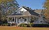
Adams-Taylor-McRae House |
Upload image |
000000001980-05-22-0000May 22, 1980
(#80002207) |
East of Pachuta
32°01′18″N 88°47′21″W / 32.021667°N 88.789167°W / 32.021667; -88.789167 (Adams-Taylor-McRae House) |
Elwood |
|
| 2 |
C.V. Akin House |
Upload image |
000000001994-05-20-0000May 20, 1994
(#94000512) |
Southern side of Clarion St., approximately ¼ mile east of U.S. Route 45
31°58′19″N 88°42′54″W / 31.971944°N 88.715°W / 31.971944; -88.715 (C.V. Akin House) |
De Soto |
|
| 3 |
Asher's Cabin |
Upload image |
000000001980-05-22-0000May 22, 1980
(#80002234) |
Mississippi Highway 513
32°08′53″N 88°48′09″W / 32.148056°N 88.8025°W / 32.148056; -88.8025 (Asher's Cabin) |
Stonewall |
|
| 4 |
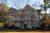
Barbour-Estes House |
Upload image |
000000001980-05-22-0000May 22, 1980
(#80002209) |
River Rd.
32°09′57″N 88°49′26″W / 32.165833°N 88.823889°W / 32.165833; -88.823889 (Barbour-Estes House) |
Enterprise |
|
| 5 |
Bradshaw-Booth House |
Upload image |
000000001980-05-22-0000May 22, 1980
(#80002210) |
Stonewall St.
32°09′55″N 88°48′47″W / 32.165278°N 88.813056°W / 32.165278; -88.813056 (Bradshaw-Booth House) |
Enterprise |
|
| 6 |
Brown-Wilson House |
Upload image |
000000001980-05-22-0000May 22, 1980
(#80002211) |
U.S. Highway 11
32°09′56″N 88°50′04″W / 32.165556°N 88.834444°W / 32.165556; -88.834444 (Brown-Wilson House) |
Enterprise |
|
| 7 |
Judge John L. Buckley House |
Upload image |
000000001994-05-20-0000May 20, 1994
(#94000513) |
Northern side of Bridge St. at its junction with Hand Ave.
32°10′33″N 88°49′29″W / 32.175833°N 88.824722°W / 32.175833; -88.824722 (Judge John L. Buckley House) |
Enterprise |
|
| 8 |
Carmichael House |
Upload image |
000000001980-05-22-0000May 22, 1980
(#80002204) |
South of De Soto along the Gulf, Mobile and Ohio railroad tracks
31°58′11″N 88°42′52″W / 31.969722°N 88.714444°W / 31.969722; -88.714444 (Carmichael House) |
De Soto |
|
| 9 |
Benjamin H. Carter House |
|
000000001994-05-20-0000May 20, 1994
(#94000514) |
210 Ferrill St.
32°02′12″N 88°43′31″W / 32.036667°N 88.725278°W / 32.036667; -88.725278 (Benjamin H. Carter House) |
Quitman |
|
| 10 |
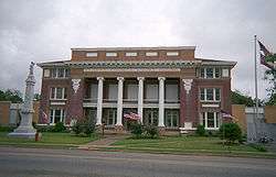
Clarke County Courthouse and Confederate Monument |
|
000000001994-05-20-0000May 20, 1994
(#94000511) |
Archusa St. at the head of Main St.
32°02′23″N 88°43′39″W / 32.039722°N 88.7275°W / 32.039722; -88.7275 (Clarke County Courthouse and Confederate Monument) |
Quitman |
|
| 11 |
Compton-Short House |
Upload image |
000000001980-05-22-0000May 22, 1980
(#80002212) |
Tuscaboma St.
32°10′28″N 88°48′10″W / 32.174444°N 88.802778°W / 32.174444; -88.802778 (Compton-Short House) |
Enterprise |
|
| 12 |
Cook-Sellers House |
Upload image |
000000001980-05-22-0000May 22, 1980
(#80002205) |
E. Station St.
31°58′24″N 88°42′46″W / 31.9734°N 88.7129°W / 31.9734; -88.7129 (Cook-Sellers House) |
De Soto |
|
| 13 |
Covington House |
Upload image |
000000001980-05-22-0000May 22, 1980
(#80002206) |
Northeast of De Soto
31°59′15″N 88°42′25″W / 31.9875°N 88.706944°W / 31.9875; -88.706944 (Covington House) |
De Soto |
|
| 14 |
Davis House |
Upload image |
000000001980-05-22-0000May 22, 1980
(#80002213) |
River Rd.
32°10′28″N 88°49′26″W / 32.174444°N 88.823889°W / 32.174444; -88.823889 (Davis House) |
Enterprise |
|
| 15 |
Dearman House |
Upload image |
000000001980-05-22-0000May 22, 1980
(#80002214) |
Bridge St. and River Rd.
32°10′27″N 88°49′26″W / 32.174167°N 88.823889°W / 32.174167; -88.823889 (Dearman House) |
Enterprise |
|
| 16 |
East Enterprise Historic District |
Upload image |
000000001994-05-20-0000May 20, 1994
(#94000510) |
Roughly bounded by S. Stonewall St., Church St., Mississippi Highway 513, and Tuscahoma Rd.
32°10′29″N 88°48′41″W / 32.174722°N 88.811389°W / 32.174722; -88.811389 (East Enterprise Historic District) |
Enterprise |
|
| 17 |
Enterprise Bridge |
Upload image |
000000001988-11-16-0000November 16, 1988
(#88002402) |
Spans the Chickasawhay River on Bridge St.
32°10′33″N 88°49′11″W / 32.175833°N 88.819722°W / 32.175833; -88.819722 (Enterprise Bridge) |
Enterprise |
|
| 18 |
Capt. C.C. Ferrill House |
|
000000001994-05-20-0000May 20, 1994
(#94000509) |
118 E. Franklin St.
32°02′09″N 88°43′31″W / 32.035833°N 88.725278°W / 32.035833; -88.725278 (Capt. C.C. Ferrill House) |
Quitman |
|
| 19 |
Ford-Williams House |
Upload image |
000000001980-05-22-0000May 22, 1980
(#80002208) |
Mississippi Highway 514
32°11′14″N 88°31′00″W / 32.187222°N 88.516667°W / 32.187222; -88.516667 (Ford-Williams House) |
Energy |
|
| 20 |
Forestdale Plantation |
Upload image |
000000001980-05-22-0000May 22, 1980
(#80002229) |
End of County Road 1222, southwest of Quitman[6]
32°00′43″N 88°49′13″W / 32.0119°N 88.8203°W / 32.0119; -88.8203 (Forestdale Plantation) |
Pachuta |
|
| 21 |
Hand House |
Upload image |
000000001980-05-22-0000May 22, 1980
(#80002231) |
North St.
31°51′45″N 88°41′49″W / 31.8625°N 88.696944°W / 31.8625; -88.696944 (Hand House) |
Shubuta |
|
| 22 |
Highway 11 Bridge over Chunky River |
|
000000001988-11-16-0000November 16, 1988
(#88002400) |
Spans the Chunky River on U.S. Route 11
32°11′32″N 88°49′30″W / 32.192222°N 88.825°W / 32.192222; -88.825 (Highway 11 Bridge over Chunky River) |
Enterprise |
|
| 23 |
House at 200 East Franklin Street |
|
000000001994-06-02-0000June 2, 1994
(#94000538) |
200 E. Franklin St.
32°02′10″N 88°43′28″W / 32.036111°N 88.724444°W / 32.036111; -88.724444 (House at 200 East Franklin Street) |
Quitman |
|
| 24 |
House on Old Mill Creek Road |
Upload image |
000000001994-05-20-0000May 20, 1994
(#94000508) |
Western side of Old Mill Creek Rd., between Old Mill Creek Rd. and U.S. Route 11
32°10′38″N 88°49′44″W / 32.177222°N 88.828889°W / 32.177222; -88.828889 (House on Old Mill Creek Road) |
Enterprise |
|
| 25 |
Hunter-Frost House |
Upload image |
000000001980-05-22-0000May 22, 1980
(#80002215) |
River Rd.
32°09′56″N 88°49′25″W / 32.165556°N 88.823611°W / 32.165556; -88.823611 (Hunter-Frost House) |
Enterprise |
|
| 26 |
J.K. Kirkland General Merchandise Store |
Upload image |
000000001994-05-20-0000May 20, 1994
(#94000507) |
124 Main St.
32°02′23″N 88°43′46″W / 32.039722°N 88.729444°W / 32.039722; -88.729444 (J.K. Kirkland General Merchandise Store) |
Quitman |
|
| 27 |
Lee-Mitts House |
Upload image |
000000001980-05-22-0000May 22, 1980
(#80002216) |
Stonewall St.
32°10′27″N 88°48′48″W / 32.174167°N 88.813333°W / 32.174167; -88.813333 (Lee-Mitts House) |
Enterprise |
|
| 28 |
McCrory-Deas-Buckley House |
Upload image |
000000001980-05-22-0000May 22, 1980
(#80002217) |
Bridge St.
32°10′27″N 88°48′48″W / 32.174167°N 88.813333°W / 32.174167; -88.813333 (McCrory-Deas-Buckley House) |
Enterprise |
|
| 29 |
Dr. McNair House |
Upload image |
000000002009-11-04-0000November 4, 2009
(#94000500) |
116 E. Church St.
32°02′25″N 88°43′37″W / 32.040233°N 88.726933°W / 32.040233; -88.726933 (Dr. McNair House) |
Quitman |
|
| 30 |
McNeill-McGee House |
Upload image |
000000001980-05-22-0000May 22, 1980
(#80002226) |
Northeast of Lake Bounds
31°53′23″N 88°53′23″W / 31.889722°N 88.889722°W / 31.889722; -88.889722 (McNeill-McGee House) |
Lake Bounds |
|
| 31 |
Methodist Parsonage House |
Upload image |
000000001980-05-22-0000May 22, 1980
(#80002219) |
A St.
32°09′57″N 88°49′26″W / 32.165833°N 88.823889°W / 32.165833; -88.823889 (Methodist Parsonage House) |
Enterprise |
|
| 32 |
Noah Moore House |
Upload image |
000000001994-05-20-0000May 20, 1994
(#94000506) |
111 Main St.
32°10′26″N 88°49′32″W / 32.173889°N 88.825556°W / 32.173889; -88.825556 (Noah Moore House) |
Enterprise |
|
| 33 |
Overseer's House and Outbuildings of Lang Plantation |
Upload image |
000000001980-05-22-0000May 22, 1980
(#80002227) |
Off County Road 610 in Langsdale[6]
31°53′21″N 88°35′11″W / 31.8892°N 88.5864°W / 31.8892; -88.5864 (Overseer's House and Outbuildings of Lang Plantation) |
Langsdale |
|
| 34 |
Pilgrim's Rest |
Upload image |
000000001980-05-22-0000May 22, 1980
(#80002220) |
Tuscaboma St.
32°10′29″N 88°48′09″W / 32.174722°N 88.8025°W / 32.174722; -88.8025 (Pilgrim's Rest) |
Enterprise |
|
| 35 |
Prairie Place |
Upload image |
000000001980-05-22-0000May 22, 1980
(#80002228) |
Off County Road 610 in Langsdale[6]
31°53′21″N 88°35′12″W / 31.8893°N 88.5867°W / 31.8893; -88.5867 (Prairie Place) |
Langsdale |
|
| 36 |
Price-Patton-Pettis House |
Upload image |
000000001980-05-22-0000May 22, 1980
(#80002232) |
North and 2nd Sts.
31°51′47″N 88°41′43″W / 31.863056°N 88.695278°W / 31.863056; -88.695278 (Price-Patton-Pettis House) |
Shubuta |
|
| 37 |
Quitman Depot |
|
000000001994-05-20-0000May 20, 1994
(#94000505) |
Eastern side of the Illinois Central Gulf railroad tracks, near the junction of Main St. and Railroad Ave.
32°02′23″N 88°43′49″W / 32.039722°N 88.730278°W / 32.039722; -88.730278 (Quitman Depot) |
Quitman |
|
| 38 |
Quitman Downtown-Mill Historic District |
Upload image |
000000002016-09-09-0000September 9, 2016
(#16000614) |
Roughly bounded by Long Blvd., Jackson, Franklin & Railroad Aves.
32°02′22″N 88°43′32″W / 32.039505°N 88.725657°W / 32.039505; -88.725657 (Quitman Downtown-Mill Historic District) |
Quitman |
|
| 39 |
Riverside Plantation |
Upload image |
000000001980-05-22-0000May 22, 1980
(#80002221) |
U.S. Highway 11
32°10′59″N 88°50′03″W / 32.183056°N 88.834167°W / 32.183056; -88.834167 (Riverside Plantation) |
Enterprise |
|
| 40 |
Shubuta Baptist Church |
Upload image |
000000001994-06-24-0000June 24, 1994
(#94000641) |
Eucutta St. at its junction with U.S. Route 45
31°51′37″N 88°42′00″W / 31.860278°N 88.7°W / 31.860278; -88.7 (Shubuta Baptist Church) |
Shubuta |
|
| 41 |
Shubuta Bridge |
Upload image |
000000001988-11-16-0000November 16, 1988
(#88002490) |
Spans the Chickasawhay River on a county road, east of Shubuta
31°51′25″N 88°41′12″W / 31.856944°N 88.686667°W / 31.856944; -88.686667 (Shubuta Bridge) |
Shubuta |
|
| 42 |
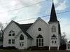
Shubuta Methodist Episcopal Church, South |
|
000000001994-05-20-0000May 20, 1994
(#94000504) |
Eastern side of High St. (U.S. Route 45)
31°51′33″N 88°41′59″W / 31.859167°N 88.699722°W / 31.859167; -88.699722 (Shubuta Methodist Episcopal Church, South) |
Shubuta |
|
| 43 |
Smith-McClain-Buckley House |
Upload image |
000000001980-05-22-0000May 22, 1980
(#80002222) |
Stonewall St.
32°09′56″N 88°48′48″W / 32.165556°N 88.813333°W / 32.165556; -88.813333 (Smith-McClain-Buckley House) |
Enterprise |
|
| 44 |
Stephenson-Allen House |
Upload image |
000000001980-05-22-0000May 22, 1980
(#80002223) |
Bridge St.
32°10′26″N 88°50′02″W / 32.173889°N 88.833889°W / 32.173889; -88.833889 (Stephenson-Allen House) |
Enterprise |
|
| 45 |
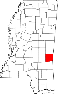
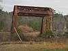
Stonewall Mill Village Historic District |
Upload image |
000000001994-05-20-0000May 20, 1994
(#94000503) |
Roughly the area surrounding Erwin Rd. between Alice and Allen Aves.
32°08′08″N 88°47′21″W / 32.135556°N 88.789167°W / 32.135556; -88.789167 (Stonewall Mill Village Historic District) |
Stonewall |
|
| 46 |
Sumrall-Albritton House |
Upload image |
000000001980-05-22-0000May 22, 1980
(#80002233) |
U.S. Highway 45
31°54′18″N 88°42′31″W / 31.905°N 88.708611°W / 31.905; -88.708611 (Sumrall-Albritton House) |
Shubuta |
|
| 47 |
Trotter-Byrd House |
Upload image |
000000001980-05-22-0000May 22, 1980
(#80002230) |
419 E. Franklin St.
32°01′55″N 88°43′31″W / 32.031944°N 88.725278°W / 32.031944; -88.725278 (Trotter-Byrd House) |
Quitman |
|
| 48 |
Ward House |
Upload image |
000000001980-05-22-0000May 22, 1980
(#80002224) |
3 miles north of Enterprise
32°12′37″N 88°50′05″W / 32.210278°N 88.834722°W / 32.210278; -88.834722 (Ward House) |
Enterprise |
|
| 49 |
Jim Williams House |
Upload image |
000000001994-05-20-0000May 20, 1994
(#94000502) |
Western side of N. River Rd., near its junction with Mississippi Highway 513
32°10′34″N 88°49′18″W / 32.176111°N 88.821667°W / 32.176111; -88.821667 (Jim Williams House) |
Enterprise |
|
| 50 |
Woolverton-Boyd House |
Upload image |
000000001980-05-22-0000May 22, 1980
(#80002225) |
Off Mississippi Highway 513
32°09′58″N 88°48′45″W / 32.166111°N 88.8125°W / 32.166111; -88.8125 (Woolverton-Boyd House) |
Enterprise |
|
| 51 |
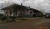
W.W. Wyatt House |
Upload image |
000000001994-05-20-0000May 20, 1994
(#94000501) |
107 N. River Rd.
32°10′37″N 88°49′18″W / 32.176944°N 88.821667°W / 32.176944; -88.821667 (W.W. Wyatt House) |
Enterprise |
|