| [3] |
Name on the Register[4] |
Image |
Date listed[5] |
Location |
City or town |
Description |
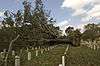
|---|
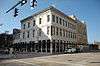
| 1 |
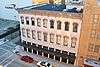
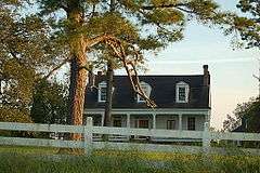
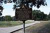
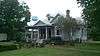
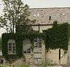
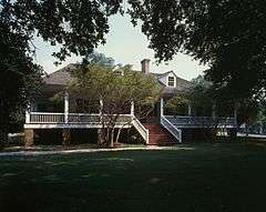
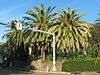
Audubon Plantation House |
|
000000001987-05-14-0000May 14, 1987
(#87000729) |
21371 Hoo Shoo Too Rd.
30°21′03″N 90°57′11″W / 30.350833°N 90.953056°W / 30.350833; -90.953056 (Audubon Plantation House) |
Baton Rouge |
|
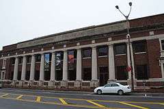
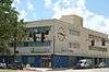
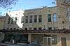
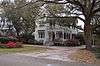
| 2 |
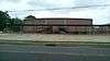
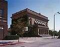
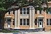
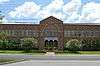
Baker High School Auditorium |
|
000000002014-01-29-0000January 29, 2014
(#13001125) |
3200 Groom Rd.
30°35′15″N 91°09′51″W / 30.587441°N 91.16422°W / 30.587441; -91.16422 (Baker High School Auditorium) |
Baker |
|
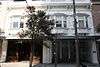
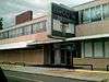
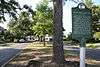
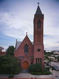
| 3 |
Baker Presbyterian Church |
|
000000001990-03-01-0000March 1, 1990
(#90000346) |
3015 Groom Rd.
30°35′18″N 91°10′09″W / 30.588333°N 91.169167°W / 30.588333; -91.169167 (Baker Presbyterian Church) |
Baker |
|
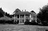
| 4 |
Barthel Pigeonnier |
|
000000001983-07-13-0000July 13, 1983
(#83000499) |
2161 Nicholson Dr.
30°25′34″N 91°11′11″W / 30.426111°N 91.186389°W / 30.426111; -91.186389 (Barthel Pigeonnier) |
Baton Rouge |
|
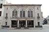
| 5 |
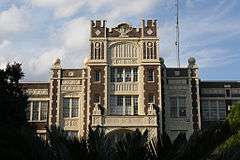
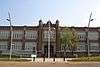
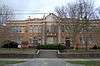
Baton Rouge High School |
|
000000001986-11-06-0000November 6, 1986
(#86003130) |
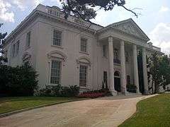
2825 Government St.
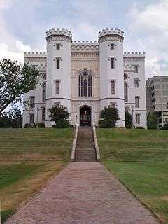
30°26′42″N 91°09′34″W / 30.445°N 91.159444°W / 30.445; -91.159444 (Baton Rouge High School) |
Baton Rouge |
|
| 6 |
Baton Rouge Junior High School |
|
000000001984-09-27-0000September 27, 1984
(#84001271) |
1100 Laurel St.
30°27′00″N 91°10′42″W / 30.45°N 91.178333°W / 30.45; -91.178333 (Baton Rouge Junior High School) |
Baton Rouge |
|
| 7 |
Baton Rouge National Cemetery |
|
000000001997-07-09-0000July 9, 1997
(#97000768) |
220 N. 19th St.
30°27′00″N 91°10′03″W / 30.45°N 91.1675°W / 30.45; -91.1675 (Baton Rouge National Cemetery) |
Baton Rouge |
|
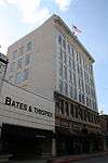
| 8 |
Baton Rouge Savings and Loan Association |
|
000000002014-01-29-0000January 29, 2014
(#13001126) |
400 North Blvd.
30°26′48″N 91°11′11″W / 30.446731°N 91.186364°W / 30.446731; -91.186364 (Baton Rouge Savings and Loan Association) |
Baton Rouge |
|
| 9 |
Baton Rouge Waterworks Company Standpipe |
|
000000001973-12-04-0000December 4, 1973
(#73002242) |
131 Lafayette St.
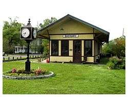
30°26′51″N 91°11′22″W / 30.4475°N 91.189444°W / 30.4475; -91.189444 (Baton Rouge Waterworks Company Standpipe) |
Baton Rouge |
|
| 10 |
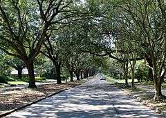
Beauregard Town Historic District |
Upload image |
000000001980-10-14-0000October 14, 1980
(#80001713) |
Louisiana Highway 73; also Front St.; also Mayflower St.; also roughly bounded by Mayflower, Interstate 10, S. 10th St., and Royal and St Charles Sts.
30°26′37″N 91°11′04″W / 30.443611°N 91.184444°W / 30.443611; -91.184444 (Beauregard Town Historic District) |
Baton Rouge |
Front St., Mayflower St., and the final set of boundaries represent boundary increases of 000000001983-04-14-0000April 14, 1983, 000000001983-10-11-0000October 11, 1983, and 000000002000-02-04-0000February 4, 2000 respectively
|
| 11 |
Belisle Building |
|
000000001993-10-19-0000October 19, 1993
(#93001104) |
344 and 350 3rd St.
30°26′59″N 91°11′16″W / 30.449722°N 91.187778°W / 30.449722; -91.187778 (Belisle Building) |
Baton Rouge |
|
| 12 |
Broussard House |
Upload image |
000000002003-07-10-0000July 10, 2003
(#03000616) |
4512 Highland Rd.
30°24′05″N 91°10′14″W / 30.401389°N 91.170556°W / 30.401389; -91.170556 (Broussard House) |
Baton Rouge |
|
| 13 |
Campbell Apartment Building |
|
000000002011-06-23-0000June 23, 2011
(#11000398) |
528 E. State St.
30°25′10″N 91°10′21″W / 30.419444°N 91.1725°W / 30.419444; -91.1725 (Campbell Apartment Building) |
Baton Rouge |
|
| 14 |
Capital City Press Building |
|
000000001986-10-16-0000October 16, 1986
(#86002870) |
340 Florida
30°26′55″N 91°11′16″W / 30.448611°N 91.187778°W / 30.448611; -91.187778 (Capital City Press Building) |
Baton Rouge |
|
| 15 |
Central Fire Station |
|
000000001984-04-05-0000April 5, 1984
(#84001277) |
427 Laurel St.
30°27′02″N 91°11′09″W / 30.450556°N 91.185833°W / 30.450556; -91.185833 (Central Fire Station) |
Baton Rouge |
|
| 16 |
City Park Golf Course |
|
000000002002-12-20-0000December 20, 2002
(#02001546) |
1442 City Park Ave.
30°25′53″N 91°10′02″W / 30.431389°N 91.167222°W / 30.431389; -91.167222 (City Park Golf Course) |
Baton Rouge |
|
| 17 |
Cushman House |
|
000000001991-02-20-0000February 20, 1991
(#91000072) |
1606 Main St.
30°35′29″N 91°10′02″W / 30.591389°N 91.167222°W / 30.591389; -91.167222 (Cushman House) |
Baker |
|
| 18 |
Downtown Baton Rouge Historic District |
|
000000002009-11-10-0000November 10, 2009
(#09000899) |
3rd St. between roughly Main St. and North Boulevard; 210-240 Laurel and 301-355 North Boulevard
30°27′05″N 91°11′18″W / 30.451478°N 91.188347°W / 30.451478; -91.188347 (Downtown Baton Rouge Historic District) |
Baton Rouge |
|
| 19 |
Drehr Place Historic District |
Upload image |
000000001997-11-13-0000November 13, 1997
(#97001422) |
Roughly bounded by Government, 22nd, Myrtle, and St. Rose Sts.
30°26′28″N 91°09′49″W / 30.441111°N 91.163611°W / 30.441111; -91.163611 (Drehr Place Historic District) |
Baton Rouge |
|
| 20 |
Dufrocq School |
|
000000002002-03-28-0000March 28, 2002
(#02000268) |
330 S. 19th St.
30°26′43″N 91°10′07″W / 30.445278°N 91.168611°W / 30.445278; -91.168611 (Dufrocq School) |
Baton Rouge |
|
| 21 |
Fairhaven Plantation House |
Upload image |
000000001988-02-11-0000February 11, 1988
(#88000102) |
18630 Samuel Rd.
30°37′45″N 91°14′00″W / 30.629167°N 91.233333°W / 30.629167; -91.233333 (Fairhaven Plantation House) |
Zachary |
|
| 22 |
Florence Coffee House |
|
000000001980-01-20-0000January 20, 1980
(#80001714) |
130 Main St.
30°27′03″N 91°11′24″W / 30.450833°N 91.19°W / 30.450833; -91.19 (Florence Coffee House) |
Baton Rouge |
|
| 23 |
The French House |
|
000000001982-01-13-0000January 13, 1982
(#82002768) |
Louisiana State University campus
30°24′38″N 91°10′29″W / 30.410556°N 91.174722°W / 30.410556; -91.174722 (The French House) |
Baton Rouge |
|
| 24 |
Fuqua Hardware Store Building |
|
000000001999-05-12-0000May 12, 1999
(#99000497) |
358 3rd St.
30°27′00″N 91°11′16″W / 30.45°N 91.187778°W / 30.45; -91.187778 (Fuqua Hardware Store Building) |
Baton Rouge |
|
| 25 |
Gracelane Plantation House |
Upload image |
000000001997-08-29-0000August 29, 1997
(#97000967) |
14444 Perkins Rd.
30°21′44″N 91°03′30″W / 30.362222°N 91.058333°W / 30.362222; -91.058333 (Gracelane Plantation House) |
Baton Rouge |
|
| 26 |
Hart House |
|
000000001980-08-01-0000August 1, 1980
(#80001715) |
Iowa St.
30°25′35″N 91°11′09″W / 30.426389°N 91.185833°W / 30.426389; -91.185833 (Hart House) |
Baton Rouge |
|
| 27 |
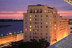
Heidelberg Hotel |
|
000000001982-05-20-0000May 20, 1982
(#82002769) |
201 Lafayette St.; also 200 Lafayette St.
30°26′55″N 91°11′23″W / 30.448611°N 91.189722°W / 30.448611; -91.189722 (Heidelberg Hotel) |
Baton Rouge |
200 Lafayette represents a boundary increase of 000000002008-08-05-0000August 5, 2008, the Heidelberg Hotel and Hotel King
|
| 28 |
Highland Stockade |
Upload image |
000000002000-03-02-0000March 2, 2000
(#00000191) |
Address Restricted
|
Baton Rouge |
|
| 29 |
Kleinert Terrace Historic District |
|
000000001998-03-05-0000March 5, 1998
(#98000180) |
Roughly bounded by Myrtle Ave., Perkins Rd., Broussard Ave., and Eugene St.
30°26′14″N 91°09′50″W / 30.437222°N 91.163889°W / 30.437222; -91.163889 (Kleinert Terrace Historic District) |
Baton Rouge |
|
| 30 |
Kleinpeter House |
Upload image |
000000001986-08-13-0000August 13, 1986
(#86001494) |
Perkins Rd.
30°20′43″N 91°01′14″W / 30.345278°N 91.020556°W / 30.345278; -91.020556 (Kleinpeter House) |
Baton Rouge |
|
| 31 |
Knox Building |
|
000000002006-08-08-0000August 8, 2006
(#06000684) |
447 3rd St.
30°27′03″N 91°11′18″W / 30.450833°N 91.188333°W / 30.450833; -91.188333 (Knox Building) |
Baton Rouge |
|
| 32 |
Kress Building |
|
000000002006-08-10-0000August 10, 2006
(#06000714) |
445 3rd St.
30°27′02″N 91°11′18″W / 30.450556°N 91.188333°W / 30.450556; -91.188333 (Kress Building) |
Baton Rouge |
|
| 33 |
Lee Site (16 EBR 51) |
Upload image |
000000001984-12-27-0000December 27, 1984
(#84000792) |
Address Restricted
|
Baton Rouge |
|
| 34 |
Leland College |
Upload image |
000000001982-11-10-0000November 10, 1982
(#82000433) |
West of Baker off Louisiana Highway 19
30°35′34″N 91°10′52″W / 30.592778°N 91.181111°W / 30.592778; -91.181111 (Leland College) |
Baker |
|
| 35 |
Les Chenes Verts |
Upload image |
000000001993-01-21-0000January 21, 1993
(#92001831) |
Junction of Highland Rd. and Jean Lafitte Ave.
30°20′51″N 91°03′48″W / 30.3475°N 91.063333°W / 30.3475; -91.063333 (Les Chenes Verts) |
Baton Rouge |
|
| 36 |
Lincoln Theater |
|
000000002010-12-07-0000December 7, 2010
(#10000980) |
1305 Myrtle Walk
30°26′18″N 91°10′32″W / 30.438333°N 91.175556°W / 30.438333; -91.175556 (Lincoln Theater) |
Baton Rouge |
|
| 37 |
Longwood |
|
000000001983-07-07-0000July 7, 1983
(#83000501) |
10417 River Rd.
30°20′28″N 91°08′24″W / 30.341111°N 91.14°W / 30.341111; -91.14 (Longwood) |
Baton Rouge |
|
| 38 |
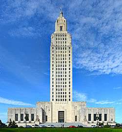
Louisiana State Capitol Building and Gardens |
|
000000001978-06-09-0000June 9, 1978
(#78001421) |
Capitol Dr.
30°27′24″N 91°11′09″W / 30.456667°N 91.185833°W / 30.456667; -91.185833 (Louisiana State Capitol Building and Gardens) |
Baton Rouge |
|
| 39 |
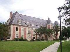
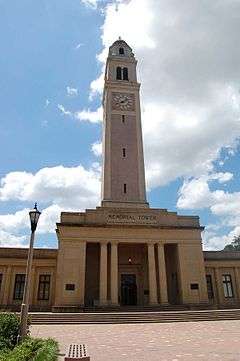
Louisiana State University, Baton Rouge |
|
000000001988-09-15-0000September 15, 1988
(#88001586) |
Highland Rd.
30°24′49″N 91°10′45″W / 30.413611°N 91.179167°W / 30.413611; -91.179167 (Louisiana State University, Baton Rouge) |
Baton Rouge |
|
| 40 |
LSU Campus Mounds |
|
000000001999-03-01-0000March 1, 1999
(#99000236) |
Junction of Dalrymple Dr. and Fieldhouse Dr. on the campus of Louisiana State University
30°24′54″N 91°10′53″W / 30.415°N 91.181389°W / 30.415; -91.181389 (LSU Campus Mounds) |
Baton Rouge |
|
| 41 |
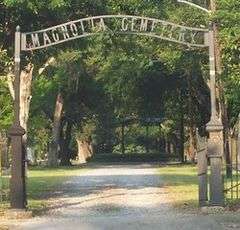
Magnolia Cemetery |
|
000000001985-01-31-0000January 31, 1985
(#85000161) |
Bounded by Main, 19th, Florida, and 22nd Sts.
30°27′03″N 91°10′02″W / 30.450833°N 91.167222°W / 30.450833; -91.167222 (Magnolia Cemetery) |
Baton Rouge |
|
| 42 |
Magnolia Mound Plantation Dependency |
|
000000001977-08-09-0000August 9, 1977
(#77000669) |
2530 Vermont St.
30°25′26″N 91°11′02″W / 30.423889°N 91.183889°W / 30.423889; -91.183889 (Magnolia Mound Plantation Dependency) |
Baton Rouge |
|
| 43 |
Magnolia Mound Plantation House |
|
000000001972-09-07-0000September 7, 1972
(#72000549) |
2161 Nicholson Dr.
30°25′34″N 91°11′13″W / 30.426111°N 91.186944°W / 30.426111; -91.186944 (Magnolia Mound Plantation House) |
Baton Rouge |
|
| 44 |
Main Street Historic District |
|
000000001985-11-07-0000November 7, 1985
(#85002785) |
442-660 Main St.
30°27′04″N 91°11′05″W / 30.451111°N 91.184722°W / 30.451111; -91.184722 (Main Street Historic District) |
Baton Rouge |
|
| 45 |
Manship House |
|
000000001980-11-21-0000November 21, 1980
(#80001716) |
2250 Kleinert Ave.
30°26′27″N 91°09′45″W / 30.440833°N 91.1625°W / 30.440833; -91.1625 (Manship House) |
Baton Rouge |
|
| 46 |
McKinley High School |
|
000000001981-11-16-0000November 16, 1981
(#81000292) |
1500 East Boulevard
30°26′01″N 91°10′44″W / 30.433611°N 91.178889°W / 30.433611; -91.178889 (McKinley High School) |
Baton Rouge |
McKinley Senior High School is at a different location
|
| 47 |
Mount Hope Plantation House |
|
000000001980-12-03-0000December 3, 1980
(#80001717) |
8151 Highland Rd.
30°22′21″N 91°07′45″W / 30.3725°N 91.129167°W / 30.3725; -91.129167 (Mount Hope Plantation House) |
Baton Rouge |
|
| 48 |
Nicholson School |
|
000000001995-01-24-0000January 24, 1995
(#94001585) |
1143 North St.
30°27′11″N 91°10′40″W / 30.453056°N 91.177778°W / 30.453056; -91.177778 (Nicholson School) |
Baton Rouge |
|
| 49 |
Old Louisiana Governor's Mansion |
|
000000001975-07-24-0000July 24, 1975
(#75000847) |
502 North Boulevard
30°26′47″N 91°11′06″W / 30.446389°N 91.185°W / 30.446389; -91.185 (Old Louisiana Governor's Mansion) |
Baton Rouge |
|
| 50 |
Old Louisiana State Capitol |
|
000000001973-01-12-0000January 12, 1973
(#73000862) |
North Boulevard and St. Philip St.
30°26′48″N 91°11′19″W / 30.446667°N 91.188611°W / 30.446667; -91.188611 (Old Louisiana State Capitol) |
Baton Rouge |
Built in 1847–1852 after the state legislature voted to move the seat of government from New Orleans, within 15 years the "castle" had been severely damaged during the Union Army's Civil War occupation of Baton Rouge. The statehouse was rebuilt and refurbished in the 1880s, including the addition of a stained glass dome. The legislature used the building for the next 50 years, until the current capitol tower was completed in 1932. Restored in the 1990s, the old capitol houses the state's Museum of Political History, which now has multimedia exhibits, free admission, and wheelchair-accessibility.
|
| 51 |
Old Post Office |
|
000000001980-06-09-0000June 9, 1980
(#80001718) |
355 North Boulevard
30°26′49″N 91°11′13″W / 30.446944°N 91.186944°W / 30.446944; -91.186944 (Old Post Office) |
Baton Rouge |
|
| 52 |
Olinde Building |
Upload image |
000000002014-04-28-0000April 28, 2014
(#13001142) |
1854 North St.
30°27′10″N 91°10′11″W / 30.452854°N 91.169702°W / 30.452854; -91.169702 (Olinde Building) |
Baton Rouge |
|
| 53 |
Ory House |
Upload image |
000000001993-01-21-0000January 21, 1993
(#92001818) |
Junction of Highland Rd. and Jean Lafitte Ave.
30°20′52″N 91°03′47″W / 30.347778°N 91.063056°W / 30.347778; -91.063056 (Ory House) |
Baton Rouge |
|
| 54 |
Pecue House |
|
000000001994-04-14-0000April 14, 1994
(#94000312) |
2260 Myrtle Ave.
30°26′18″N 91°09′49″W / 30.438333°N 91.163611°W / 30.438333; -91.163611 (Pecue House) |
Baton Rouge |
|
| 55 |
Pentagon Barracks |
|
000000001973-07-26-0000July 26, 1973
(#73000863) |
North Riverside Mall
30°27′19″N 91°11′20″W / 30.455278°N 91.188889°W / 30.455278; -91.188889 (Pentagon Barracks) |
Baton Rouge |
|
| 56 |
Sarah Peralta Archeological Site |
Upload image |
000000001995-03-02-0000March 2, 1995
(#95000134) |
Address Restricted
|
Baton Rouge |
|
| 57 |
Joseph Petitpierre-Kleinpeter House |
Upload image |
000000001986-01-23-0000January 23, 1986
(#86000111) |
5544 Highland Rd.
30°23′30″N 91°09′26″W / 30.391667°N 91.157222°W / 30.391667; -91.157222 (Joseph Petitpierre-Kleinpeter House) |
Baton Rouge |
|
| 58 |
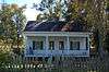
Planter's Cabin |
|
000000001984-08-23-0000August 23, 1984
(#84001279) |
7815 Highland Rd.
30°22′31″N 91°08′01″W / 30.375278°N 91.133611°W / 30.375278; -91.133611 (Planter's Cabin) |
Baton Rouge |
|
| 59 |
Port Hudson National Cemetery |
|
000000001999-05-20-0000May 20, 1999
(#99000591) |
20978 Port Hickey Rd.
30°39′37″N 91°16′26″W / 30.660278°N 91.273889°W / 30.660278; -91.273889 (Port Hudson National Cemetery) |
Zachary |
Established to bury thousands of Union Army soldiers who fell during the longest siege in U.S. history, 1863's Siege of Port Hudson.
|
| 60 |
Potts House |
|
000000001972-09-14-0000September 14, 1972
(#72000550) |
831 North St.
30°27′11″N 91°10′52″W / 30.453056°N 91.181111°W / 30.453056; -91.181111 (Potts House) |
Baton Rouge |
|
| 61 |
Powder Magazine |
|
000000001973-06-04-0000June 4, 1973
(#73000864) |
State Capitol Dr.
30°27′27″N 91°11′38″W / 30.4575°N 91.193889°W / 30.4575; -91.193889 (Powder Magazine) |
Baton Rouge |
|
| 62 |
Prince Hall Masonic Temple |
|
000000001994-06-02-0000June 2, 1994
(#94000498) |
1335 North Boulevard
30°26′51″N 91°10′31″W / 30.4475°N 91.175278°W / 30.4475; -91.175278 (Prince Hall Masonic Temple) |
Baton Rouge |
|
| 63 |
Rabalais House |
|
000000002010-06-24-0000June 24, 2010
(#10000388) |
1300 Steele Blvd.
30°26′14″N 91°09′03″W / 30.437222°N 91.150833°W / 30.437222; -91.150833 (Rabalais House) |
Baton Rouge |
|
| 64 |
Reiley-Reeves House |
|
000000001979-05-24-0000May 24, 1979
(#79001060) |
810 Park Boulevard
30°26′26″N 91°10′08″W / 30.440556°N 91.168889°W / 30.440556; -91.168889 (Reiley-Reeves House) |
Baton Rouge |
|
| 65 |
Reymond House |
|
000000001998-06-03-0000June 3, 1998
(#98000663) |
7250 Goodwood Boulevard
30°26′30″N 91°06′42″W / 30.441667°N 91.111667°W / 30.441667; -91.111667 (Reymond House) |
Baton Rouge |
|
| 66 |
Roseland Terrace Historic District |
|
000000001982-03-11-0000March 11, 1982
(#82002770) |
Bounded by Government, 18th, Myrtle, and 22nd Sts.
30°26′27″N 91°10′03″W / 30.440833°N 91.1675°W / 30.440833; -91.1675 (Roseland Terrace Historic District) |
Baton Rouge |
|
| 67 |
Roumain Building |
|
000000001985-04-11-0000April 11, 1985
(#85000727) |
343 Riverside Mall
30°26′59″N 91°11′18″W / 30.449722°N 91.188333°W / 30.449722; -91.188333 (Roumain Building) |
Baton Rouge |
|
| 68 |
St. James Episcopal Church |
|
000000001978-05-05-0000May 5, 1978
(#78001423) |
208 N. 4th St.
30°26′54″N 91°11′12″W / 30.448333°N 91.186667°W / 30.448333; -91.186667 (St. James Episcopal Church) |
Baton Rouge |
|
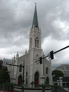
| 69 |
St. Joseph Cathedral |
|
000000001990-03-22-0000March 22, 1990
(#90000502) |
Main and 4th Sts.
30°27′06″N 91°11′11″W / 30.451667°N 91.186389°W / 30.451667; -91.186389 (St. Joseph Cathedral) |
Baton Rouge |
|
| 70 |
Jared Young Sanders, Jr., House |
|
000000001997-02-14-0000February 14, 1997
(#97000056) |
2332 Wisteria St.
30°26′34″N 91°09′48″W / 30.442778°N 91.163333°W / 30.442778; -91.163333 (Jared Young Sanders, Jr., House) |
Baton Rouge |
|
| 71 |
Santa Maria Plantation House |
|
000000001978-12-29-0000December 29, 1978
(#78003448) |
South of Baton Rouge on Perkins Rd.
30°20′35″N 91°00′59″W / 30.343056°N 91.016389°W / 30.343056; -91.016389 (Santa Maria Plantation House) |
Baton Rouge |
|
| 72 |
Scott Street School |
|
000000001994-07-07-0000July 7, 1994
(#94000681) |
900 N. 19th St.
30°27′23″N 91°10′09″W / 30.456389°N 91.169167°W / 30.456389; -91.169167 (Scott Street School) |
Baton Rouge |
|
| 73 |
John and Amelia Sharp House |
Upload image |
000000002015-10-06-0000October 6, 2015
(#15000693) |
7585 Willow Grove Blvd.
30°22′43″N 91°05′01″W / 30.3787°N 91.0835°W / 30.3787; -91.0835 (John and Amelia Sharp House) |
Baton Rouge |
|
| 74 |
Southern University Archives Building |
|
000000001981-06-11-0000June 11, 1981
(#81000294) |
Southern University campus
30°31′18″N 91°13′06″W / 30.521667°N 91.218333°W / 30.521667; -91.218333 (Southern University Archives Building) |
Scotlandville |
|
| 75 |
Southern University Historic District |
|
000000001999-05-20-0000May 20, 1999
(#99000590) |
Netterville Dr. and Swan Ave.
30°31′23″N 91°11′52″W / 30.523056°N 91.197778°W / 30.523056; -91.197778 (Southern University Historic District) |
Baton Rouge |
|
| 76 |
Spanish Town |
|
000000001978-08-31-0000August 31, 1978
(#78001422) |
Bounded by State Capitol Dr. and 5th, 9th, and North Sts.
30°27′16″N 91°11′00″W / 30.454444°N 91.183333°W / 30.454444; -91.183333 (Spanish Town) |
Baton Rouge |
|
| 77 |
Stewart-Dougherty House |
|
000000001973-03-28-0000March 28, 1973
(#73000865) |
741 North St.
30°27′11″N 91°10′57″W / 30.453056°N 91.1825°W / 30.453056; -91.1825 (Stewart-Dougherty House) |
Baton Rouge |
|
| 78 |
Tessier Buildings |
|
000000001978-03-16-0000March 16, 1978
(#78001424) |
342, 346, and 348 Lafayette St.
30°26′59″N 91°11′20″W / 30.449722°N 91.188889°W / 30.449722; -91.188889 (Tessier Buildings) |
Baton Rouge |
|
| 79 |
U.S.S. Kidd |
|
000000001983-08-09-0000August 9, 1983
(#83000502) |
Mississippi River near Government St. and River Rd.
30°26′39″N 91°11′30″W / 30.444167°N 91.191667°W / 30.444167; -91.191667 (U.S.S. Kidd) |
Baton Rouge |
|
| 80 |
US Post Office and Courthouse-Baton Rouge |
|
000000002000-05-18-0000May 18, 2000
(#00000500) |
707 Florida Ave.
30°26′58″N 91°10′44″W / 30.449444°N 91.178889°W / 30.449444; -91.178889 (US Post Office and Courthouse-Baton Rouge) |
Baton Rouge |
|
| 81 |
Union Federal Savings and Loan Association |
|
000000002015-11-24-0000November 24, 2015
(#15000848) |
500 Laurel St.
30°27′02″N 91°11′09″W / 30.4505°N 91.1857°W / 30.4505; -91.1857 (Union Federal Savings and Loan Association) |
Baton Rouge |
|
| 82 |
Virginia Street Historic District |
Upload image |
000000002011-10-25-0000October 25, 2011
(#11000761) |
4512-4642 Virginia & 4338 Florida Sts.
30°38′50″N 91°09′22″W / 30.647222°N 91.156111°W / 30.647222; -91.156111 (Virginia Street Historic District) |
Zachary |
|
| 83 |
Warden's House-Old Louisiana State Penitentiary |
|
000000001974-12-02-0000December 2, 1974
(#74000921) |
701-705 Laurel St.
30°27′01″N 91°10′59″W / 30.450278°N 91.183056°W / 30.450278; -91.183056 (Warden's House-Old Louisiana State Penitentiary) |
Baton Rouge |
|
| 84 |
Welsh-Levy Building |
|
000000002006-08-08-0000August 8, 2006
(#06000685) |
455-65 3rd St.
30°27′04″N 91°11′18″W / 30.451111°N 91.188333°W / 30.451111; -91.188333 (Welsh-Levy Building) |
Baton Rouge |
|
| 85 |
Fonville Winans Studio |
|
000000001999-08-27-0000August 27, 1999
(#99001052) |
409 N. 7th St.
30°27′02″N 91°11′01″W / 30.450556°N 91.183611°W / 30.450556; -91.183611 (Fonville Winans Studio) |
Baton Rouge |
The studio of photographer Fonville Winans
|
| 86 |
Yazoo and Mississippi Valley Railroad Company Depot |
|
000000001994-05-19-0000May 19, 1994
(#94000463) |
100 S. River Rd.
30°26′47″N 91°11′24″W / 30.446389°N 91.19°W / 30.446389; -91.19 (Yazoo and Mississippi Valley Railroad Company Depot) |
Baton Rouge |
|
| 87 |
Zachary Railroad Depot |
|
000000001983-12-28-0000December 28, 1983
(#83003615) |
4434 W. Central Ave.
30°38′52″N 91°09′25″W / 30.647778°N 91.156944°W / 30.647778; -91.156944 (Zachary Railroad Depot) |
Zachary |
|


.jpg)

.jpg)

.jpg)
.jpg)


.jpg)


%2C_January_2013.jpg)
.jpg)