National Register of Historic Places listings in Fluvanna County, Virginia
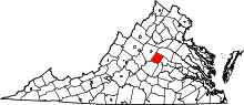
Location of Fluvanna County in Virginia
This is a list of the National Register of Historic Places listings in Fluvanna County, Virginia.
This is intended to be a complete list of the properties and districts on the National Register of Historic Places in Fluvanna County, Virginia, United States. The locations of National Register properties and districts for which the latitude and longitude coordinates are included below, may be seen in a Google map.[1]
There are 18 properties and districts listed on the National Register in the county, including 1 National Historic Landmark.
- This National Park Service list is complete through NPS recent listings posted December 2, 2016.[2]
Current listings
| [3] |
Name on the Register[4] |
Image |
Date listed[5] |
Location |
City or town |
Description |
|---|
| 1 |
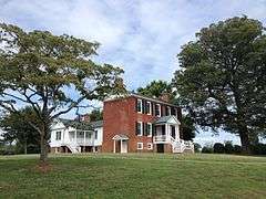
Bremo Plantation |
|
000000001969-11-12-0000November 12, 1969
(#69000241) |
West of Bremo Bluff off U.S. 15
37°43′48″N 78°19′09″W / 37.73°N 78.319167°W / 37.73; -78.319167 (Bremo Plantation) |
Bremo Bluff |
|
| 2 |
Bremo Slave Chapel |
|
000000001980-03-17-0000March 17, 1980
(#80004189) |
North of Bremo Bluff
37°43′01″N 78°17′51″W / 37.716944°N 78.2975°W / 37.716944; -78.2975 (Bremo Slave Chapel) |
Bremo Bluff |
|
| 3 |
Fluvanna County Courthouse Historic District |
|
000000001971-09-22-0000September 22, 1971
(#71000977) |
Roughly bounded by VA 601, Virginia 15, and the Rivanna River
37°51′41″N 78°15′59″W / 37.861389°N 78.266389°W / 37.861389; -78.266389 (Fluvanna County Courthouse Historic District) |
Palmyra |
|
| 4 |
Glen Arvon |
Upload image |
000000001976-05-28-0000May 28, 1976
(#76002106) |
East of Bremo Bluff near the junction of VA 655 and VA 656
37°42′15″N 78°14′48″W / 37.704167°N 78.246667°W / 37.704167; -78.246667 (Glen Arvon) |
Bremo Bluff |
|
| 5 |
Glen Burnie |
Upload image |
000000002000-08-02-0000August 2, 2000
(#00000893) |
US 15, 0.25 miles (0.40 km) north of Palmyra
37°52′01″N 78°15′27″W / 37.866944°N 78.2575°W / 37.866944; -78.2575 (Glen Burnie) |
Palmyra |
|
| 6 |
Gum Creek |
Upload image |
000000002003-10-22-0000October 22, 2003
(#03001084) |
1317 Stage Junction Rd.
37°46′29″N 78°09′33″W / 37.774844°N 78.159175°W / 37.774844; -78.159175 (Gum Creek) |
Columbia |
|
| 7 |
Laughton |
Upload image |
000000002002-04-01-0000April 1, 2002
(#02000318) |
VA 623
37°53′46″N 78°06′46″W / 37.896111°N 78.112778°W / 37.896111; -78.112778 (Laughton) |
Kents Store |
|
| 8 |
Melrose |
|
000000002000-08-14-0000August 14, 2000
(#00000892) |
VA 640, southwest of the junction of VA 640 and VA 650
37°44′19″N 78°21′42″W / 37.738611°N 78.361667°W / 37.738611; -78.361667 (Melrose) |
Fork Union |
|
| 9 |
The Oaks |
Upload image |
000000002001-07-13-0000July 13, 2001
(#01000696) |
5025 Tabscott Rd.
37°52′24″N 78°05′09″W / 37.873231°N 78.085775°W / 37.873231; -78.085775 (The Oaks) |
Kents Store |
|
| 10 |
Pleasant Grove |
|
000000002004-08-12-0000August 12, 2004
(#04000843) |
Thomas Jefferson Pkwy, Virginia 53
37°52′27″N 78°17′32″W / 37.874167°N 78.292222°W / 37.874167; -78.292222 (Pleasant Grove) |
Palmyra |
|
| 11 |
Point of Fork Arsenal |
Upload image |
000000001969-10-01-0000October 1, 1969
(#69000242) |
Address Restricted
|
Columbia |
|
| 12 |
Point of Fork Plantation |
Upload image |
000000001974-08-13-0000August 13, 1974
(#74002116) |
West of Columbia off VA 624
37°45′07″N 78°10′34″W / 37.751944°N 78.176111°W / 37.751944; -78.176111 (Point of Fork Plantation) |
Columbia |
|
| 13 |
Rivanna Farm |
Upload image |
000000002001-02-16-0000February 16, 2001
(#01000147) |
Route 1
37°44′08″N 78°12′36″W / 37.735556°N 78.21°W / 37.735556; -78.21 (Rivanna Farm) |
Bremo Bluff |
|
| 14 |
Scottsville Historic District |
|
000000001976-07-30-0000July 30, 1976
(#76002093) |
VA 6
37°47′58″N 78°29′34″W / 37.799444°N 78.492778°W / 37.799444; -78.492778 (Scottsville Historic District) |
Scottsville |
Also listed in the NRIS database in Albemarle County
|
| 15 |
Seay's Chapel Methodist Church |
Upload image |
000000002012-08-22-0000August 22, 2012
(#12000540) |
4916 Shores Rd.
37°44′41″N 78°21′38″W / 37.744649°N 78.360652°W / 37.744649; -78.360652 (Seay's Chapel Methodist Church) |
Palmyra |
|
| 16 |
Seven Islands Archeological and Historic District |
Upload image |
000000001991-07-03-0000July 3, 1991
(#91000832) |
Address Restricted
|
Arvonia |
Also listed in the NRIS database in Buckingham County
|
| 17 |
Union Mills Canal Outlet Locks #1 and #2 |
Upload image |
000000001999-10-14-0000October 14, 1999
(#99001256) |
Address Restricted
|
Crofton |
|
| 18 |
Western View |
Upload image |
000000002002-04-01-0000April 1, 2002
(#02000320) |
VA 658
37°44′06″N 78°21′22″W / 37.735°N 78.356111°W / 37.735; -78.356111 (Western View) |
Fork Union |
|
See also
References
- ↑ The latitude and longitude information provided in this table was derived originally from the National Register Information System, which has been found to be fairly accurate for about 99% of listings. For about 1% of NRIS original coordinates, experience has shown that one or both coordinates are typos or otherwise extremely far off; some corrections may have been made. A more subtle problem causes many locations to be off by up to 150 yards, depending on location in the country: most NRIS coordinates were derived from tracing out latitude and longitudes off of USGS topographical quadrant maps created under the North American Datum of 1927, which differs from the current, highly accurate WGS84 GPS system used by most on-line maps. Chicago is about right, but NRIS longitudes in Washington are higher by about 4.5 seconds, and are lower by about 2.0 seconds in Maine. Latitudes differ by about 1.0 second in Florida. Some locations in this table may have been corrected to current GPS standards.
- ↑ "National Register of Historic Places: Weekly List Actions". National Park Service, United States Department of the Interior. Retrieved on December 2, 2016.
- ↑ Numbers represent an ordering by significant words. Various colorings, defined here, differentiate National Historic Landmarks and historic districts from other NRHP buildings, structures, sites or objects.
- ↑ National Park Service (2008-04-24). "National Register Information System". National Register of Historic Places. National Park Service.
- ↑ The eight-digit number below each date is the number assigned to each location in the National Register Information System database, which can be viewed by clicking the number.
|
|---|
|
Lists
by county | | |
|---|
|
Lists
by city | |
|---|
|
| Other lists | |
|---|
|
|
.jpg)


.jpg)
.jpg)