National Register of Historic Places listings in Hughes County, South Dakota
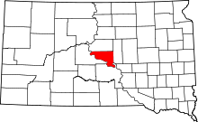
Location of Hughes County in South Dakota
This is a list of the National Register of Historic Places listings in Hughes County, South Dakota.
This is intended to be a complete list of the properties and districts on the National Register of Historic Places in Hughes County, South Dakota, United States. The locations of National Register properties and districts for which the latitude and longitude coordinates are included below, may be seen in a map.[1]
There are 41 properties and districts listed on the National Register in the county, including 1 National Historic Landmark.
- This National Park Service list is complete through NPS recent listings posted December 2, 2016.[2]
Current listings
| [3] | Name on the Register[4] | Image | Date listed[5] | Location | City or town | Description |
|---|---|---|---|---|---|---|
| 1 | Archeological Site 39HU66 | Upload image | (#84003297) |
Address Restricted |
Canning | part of the Petroforms of South Dakota Thematic Resource (TR) |
| 2 | Archeological Site 39HU189 | Upload image | (#84003307) |
Address Restricted |
Macs Corner | part of the Petroforms of South Dakota TR |
| 3 | Archeological Site 39HU201 | Upload image | (#84003308) |
Address Restricted |
Pierre | part of the Petroforms of South Dakota TR |
| 4 | Arzberger Site | 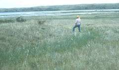 |
(#66000715) |
Atop the bluff above the McClure Site[6]:3 44°20′54″N 100°11′48″W / 44.348333°N 100.196667°W |
Pierre | |
| 5 | Dr. William and Elizabeth Blackburn House | Upload image | (#97000426) |
219 S. Tyler Ave. 44°21′44″N 100°19′37″W / 44.362222°N 100.326944°W |
Pierre | |
| 6 | Brink-Wegner House | Upload image | (#78002557) |
110 E. 4th St. 44°22′44″N 100°20′56″W / 44.378924°N 100.348994°W |
Pierre | |
| 7 | Cedar Islands Archeological District | Upload image | (#86002739) |
Address Restricted |
Pierre | part of the Big Bend Area Multiple Resource Area (MRA) |
| 8 | Central Block | 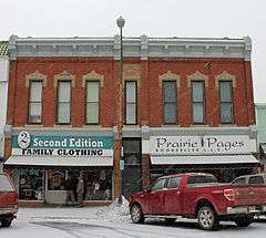 |
(#88003201) |
321-325 S. Pierre St. 44°21′56″N 100°21′19″W / 44.365556°N 100.355278°W |
Pierre | |
| 9 | Chicago and North Western Railroad Bridge | 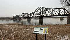 |
(#98001412) |
North of U.S. Routes 14/83 over the Missouri River 44°22′25″N 100°22′12″W / 44.373611°N 100.37°W |
Pierre | part of the Historic Railroads of South Dakota Multiple Property Submission (MPS) |
| 10 | Crawford-Pettyjohn House | 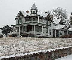 |
(#77001245) |
129 S. Washington St. 44°21′49″N 100°20′09″W / 44.363611°N 100.335833°W |
Pierre | |
| 11 | Farr House | 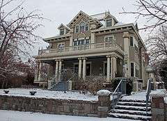 |
(#80003723) |
106 E. Wynoka St. 44°22′17″N 100°20′56″W / 44.371389°N 100.348889°W |
Pierre | |
| 12 | Fort George Creek Archeological District | Upload image | (#86002741) |
Address Restricted |
Pierre | part of the Big Bend Area MRA |
| 13 | I. W. Goodner House | 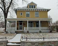 |
(#95000278) |
216 E. Prospect Ave. 44°22′44″N 100°20′59″W / 44.378889°N 100.349722°W |
Pierre | |
| 14 | Mentor Graham House | Upload image | (#76001736) |
U.S. Route 14 44°30′45″N 99°59′22″W / 44.5125°N 99.989444°W |
Blunt | |
| 15 | Peter Hansen House |  |
(#98001410) |
1123 E. Capitol St. 44°22′23″N 100°20′09″W / 44.373056°N 100.335833°W |
Pierre | part of the Lustron Houses in South Dakota MPS |
| 16 | Harrold School | Upload image | (#03001073) |
206 S. Nixon Ave. 44°31′29″N 99°44′01″W / 44.524722°N 99.733611°W |
Harrold | part of the Schools in South Dakota MPS |
| 17 | Hilger Block | 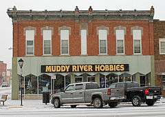 |
(#06000456) |
361 S. Pierre 44°22′05″N 100°21′19″W / 44.368056°N 100.355278°W |
Pierre | |
| 18 | John E. and Ruth Hipple House | 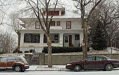 |
(#01000641) |
219 N. Highland 44°22′09″N 100°20′51″W / 44.369167°N 100.3475°W |
Pierre | |
| 19 | Horner-Hyde House | 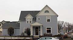 |
(#88002836) |
100 W. Capitol Ave. 44°22′10″N 100°21′05″W / 44.369444°N 100.351389°W |
Pierre | |
| 20 | Hughes County Courthouse | 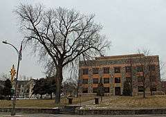 |
(#92001859) |
Capitol Ave. between Grand and Euclid Aves. 44°22′09″N 100°21′02″W / 44.369167°N 100.350556°W |
Pierre | part of the County Courthouses of South Dakota MPS |
| 21 | Hyde Buildings | Upload image | (#83003009) |
101½, 105, 108½, and 109 S. Pierre St., and 105½ Capitol Ave. 44°22′07″N 100°21′05″W / 44.368611°N 100.351389°W |
Pierre | |
| 22 | Karcher Block | 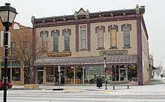 |
(#93000783) |
366 S. Pierre St. 44°21′57″N 100°21′16″W / 44.365833°N 100.354444°W |
Pierre | |
| 23 | Karcher-Sahr House | 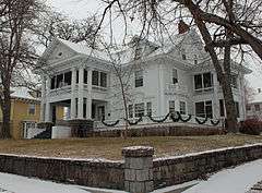 |
(#77001246) |
222 E. Prospect St. 44°22′09″N 100°20′45″W / 44.369167°N 100.345833°W |
Pierre | |
| 24 | McClure Site (39HU7) | Upload image | (#86002732) |
Southern side of Highway 34 in the SE¼ NE¼ NW¼ of Section 15, T110N R78W[6]:4 44°20′09″N 100°12′00″W / 44.335833°N 100.20000°W |
Pierre | part of the Big Bend Area MRA |
| 25 | Henry M. McDonald House | Upload image | (#89001718) |
1906 E. Erskine 44°21′48″N 100°19′30″W / 44.363333°N 100.325°W |
Pierre | |
| 26 | George McMillen House | 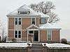 |
(#83003010) |
111 E. Broadway 44°22′15″N 100°20′58″W / 44.370833°N 100.349444°W |
Pierre | |
| 27 | Judge C. D. Meade House | 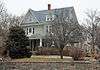 |
(#77001247) |
106 W. Prospect St. 44°22′13″N 100°21′02″W / 44.370278°N 100.350556°W |
Pierre | |
| 28 | Medicine Creek Archeological District | Upload image | (#86002740) |
Address Restricted |
Lower Brule | Extends into Lyman County; part of the Big Bend Area MRA |
| 29 | Methodist Episcopal Church | 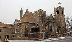 |
(#97000428) |
117 Central Ave., N. 44°22′16″N 100°21′12″W / 44.371111°N 100.353333°W |
Pierre | |
| 30 | Oahe Addition Historic District | Upload image | (#00000599) |
Roughly bounded by N. Poplar, LaBarge Ct., and 3rd and 4th Sts. 44°22′43″N 100°21′26″W / 44.378611°N 100.357222°W |
Pierre | |
| 31 | Oahe Chapel | 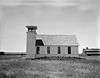 |
(#80003725) |
Northwest of Pierre 44°27′29″N 100°23′08″W / 44.458056°N 100.385556°W |
Pierre | |
| 32 | Old Fort Sully Site (39HU52) | Upload image | (#86002731) |
Address Restricted |
Pierre | part of the Big Bend Area MRA |
| 33 | Pierre Hill Residential Historic District | 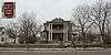 |
(#98000075) |
Roughly bounded by Huron Ave., Elizabeth St., Euclid Ave., and Broadway 44°22′20″N 100°20′52″W / 44.372222°N 100.347778°W |
Pierre | |
| 34 | Pierre Masonic Lodge | 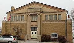 |
(#09000447) |
210 W. Capitol Ave. 44°22′11″N 100°21′12″W / 44.369798°N 100.353286°W |
Pierre | |
| 35 | Pringle House | Upload image | (#12000485) |
102 N. Jefferson 44°22′04″N 100°20′13″W / 44.36772°N 100.337065°W |
Pierre | |
| 36 | Rowe House | 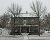 |
(#01000095) |
1118 E. Capitol 44°21′52″N 100°20′08″W / 44.364444°N 100.335556°W |
Pierre | |
| 37 | St. Charles Hotel | 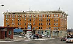 |
(#80003724) |
207 E. Capitol Ave. 44°22′06″N 100°21′01″W / 44.368333°N 100.350278°W |
Pierre | |
| 38 | Kenneth R. Scurr House | Upload image | (#93000780) |
121 S. Washington Ave. 44°21′54″N 100°19′36″W / 44.365°N 100.326667°W |
Pierre | |
| 39 | Soldiers & Sailors World War Memorial | |
(#83003011) |
Capitol Ave. 44°21′58″N 100°20′49″W / 44.366111°N 100.346944°W |
Pierre | |
| 40 | South Dakota State Capitol | 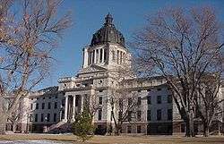 |
(#76001737) |
Bounded by Broadway, Washington, and Capitol Aves. 44°22′43″N 100°21′17″W / 44.378611°N 100.354722°W |
Pierre | |
| 41 | Stephens-Lucas House | 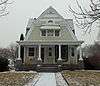 |
(#77001248) |
123 N. Nicollette 44°22′07″N 100°20′43″W / 44.368611°N 100.345278°W |
Pierre |
Former listings
| [3] | Name on the Register | Image | Date listed | Date removed | Location | City or town | Summary |
|---|---|---|---|---|---|---|---|
| 1 | Brandhuber Ice Company Barn | Upload image | (#80003722) | 419 S. Fort St. |
Pierre |
See also
| Wikimedia Commons has media related to National Register of Historic Places in Hughes County, South Dakota. |
- List of National Historic Landmarks in South Dakota
- National Register of Historic Places listings in South Dakota
References
- ↑ The latitude and longitude information provided in this table was derived originally from the National Register Information System, which has been found to be fairly accurate for about 99% of listings. For about 1% of NRIS original coordinates, experience has shown that one or both coordinates are typos or otherwise extremely far off; some corrections may have been made. A more subtle problem causes many locations to be off by up to 150 yards, depending on location in the country: most NRIS coordinates were derived from tracing out latitude and longitudes off of USGS topographical quadrant maps created under the North American Datum of 1927, which differs from the current, highly accurate WGS84 GPS system used by most on-line maps. Chicago is about right, but NRIS longitudes in Washington are higher by about 4.5 seconds, and are lower by about 2.0 seconds in Maine. Latitudes differ by about 1.0 second in Florida. Some locations in this table may have been corrected to current GPS standards.
- ↑ "National Register of Historic Places: Weekly List Actions". National Park Service, United States Department of the Interior. Retrieved on December 2, 2016.
- 1 2 Numbers represent an ordering by significant words. Various colorings, defined here, differentiate National Historic Landmarks and historic districts from other NRHP buildings, structures, sites or objects.
- ↑ National Park Service (2008-04-24). "National Register Information System". National Register of Historic Places. National Park Service.
- ↑ The eight-digit number below each date is the number assigned to each location in the National Register Information System database, which can be viewed by clicking the number.
- 1 2 "The McClure Site and Excavated Features the [sic] Site". Plains Anthropologist 27.98 (1982): 3-14.
| Topics | |
|---|---|
| Lists by states |
|
| Lists by insular areas | |
| Lists by associated states | |
| Other areas | |
| |
Municipalities and communities of Hughes County, South Dakota, United States | ||
|---|---|---|
| Cities | | |
| Town | ||
| Indian reservation | ||
| Unincorporated communities | ||
| Footnotes | ‡This populated place also has portions in an adjacent county or counties | |
This article is issued from Wikipedia - version of the 5/8/2016. The text is available under the Creative Commons Attribution/Share Alike but additional terms may apply for the media files.