National Register of Historic Places listings in Jefferson County, Wisconsin

Location of Jefferson County in Wisconsin
This is a list of the National Register of Historic Places listings in Jefferson County, Wisconsin. It is intended to provide a comprehensive listing of entries in the National Register of Historic Places that are located in Jefferson County, Wisconsin. The locations of National Register properties for which the latitude and longitude coordinates are included below may be seen in a map.[1]
There are 48 properties and districts listed on the National Register in the county.
- This National Park Service list is complete through NPS recent listings posted December 2, 2016.[2]
Current listings
| [3] | Name on the Register | Image | Date listed[4] | Location | City or town | Description |
|---|---|---|---|---|---|---|
| 1 | Aztalan | 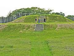 |
(#66000022) |
Near Lake Mills on WI 89, Aztalan State Park 43°04′03″N 88°51′40″W / 43.0675°N 88.861111°W |
Lake Mills | |
| 2 | Beals and Torrey Shoe Co. Building | 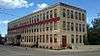 |
(#84000699) |
100 W. Milwaukee St. 43°11′24″N 88°43′36″W / 43.19°N 88.726667°W |
Watertown | |
| 3 | Bean Lake Islands Archeological District |  |
(#82000673) |
Address Restricted |
Lake Mills | |
| 4 | Carcajou Point (47 Je 2) | |
(#79000088) |
Address Restricted |
Busseyville | |
| 5 | Chicago and Northwest Railroad Passenger Station | 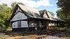 |
(#79000086) |
725 W. Main St. 43°11′40″N 88°44′05″W / 43.194444°N 88.734722°W |
Watertown | |
| 6 | City of Waterloo Carousel |  |
(#97000890) |
500 Park Ave. 43°10′49″N 88°59′05″W / 43.180278°N 88.984722°W |
Waterloo | Located at Firemen's Park. Carousel went underwater in 2008 flood of the Maunesha River. It was restored by 2011 and moved to higher ground.[5] |
| 7 | Clyman Street Historic District | 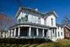 |
(#15000503) |
Roughly bounded by Western Ave,. Clyman, S. 10th & S. 5th Sts. 43°11′14″N 88°43′06″W / 43.187350°N 88.718317°W |
Watertown | |
| 8 | Copeland-Ryder Company |  |
(#89000233) |
411 Wisconsin Dr. 43°00′06″N 88°48′46″W / 43.001667°N 88.812778°W |
Jefferson | utilitarian-industrial design |
| 9 | David W. and Jane Curtis House |  |
(#09000309) |
213 E. Sherman Ave. 42°55′48″N 88°50′04″W / 42.929864°N 88.834539°W |
Fort Atkinson | |
| 10 | Crab Apple Point Site | |
(#78000104) |
Address Restricted |
Edgerton | |
| 11 | Enterprise Building |  |
(#75000068) |
125 W. Main St. 42°52′40″N 88°35′06″W / 42.877778°N 88.585°W |
Palmyra | |
| 12 | Enoch J. Fargo House |  |
(#82000674) |
406 Mulberry St. 43°04′53″N 88°54′27″W / 43.081389°N 88.9075°W |
Lake Mills | |
| 13 | L. D. Fargo Public Library | 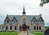 |
(#82000675) |
120 E. Madison St. 43°04′51″N 88°54′38″W / 43.080833°N 88.910556°W |
Lake Mills | 1899-1902, Gothic revival style with storybook elements, George B. Ferry & Alfred C. Clas |
| 14 | First Kindergarten | 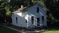 |
(#72000055) |
919 Charles St. 43°11′04″N 88°42′26″W / 43.184444°N 88.707222°W |
Watertown | |
| 15 | Fort Atkinson Water Tower | 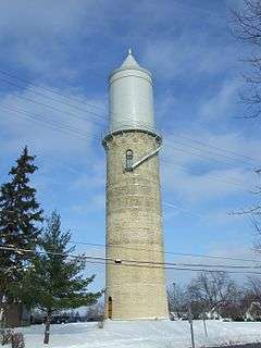 |
(#05001298) |
S. High and Fourth Sts. 42°55′33″N 88°49′58″W / 42.925833°N 88.832778°W |
Fort Atkinson | |
| 16 | August and Eliza Fuermann Jr. House | 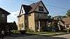 |
(#89001002) |
500 S. Third St. 43°11′28″N 88°43′23″W / 43.191111°N 88.723056°W |
Watertown | |
| 17 | Haight Creek Mound Group (47-Je-38) | |
(#85001751) |
Address Restricted |
Fort Atkinson | |
| 18 | Hebron Town Hall | 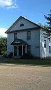 |
(#02001666) |
W3087 Green Isle Dr. 42°55′31″N 88°41′19″W / 42.925278°N 88.688611°W |
Hebron | |
| 19 | Highsmith Site | Upload image | (#78000106) |
NE of Fort Atkinson Coordinates missing |
Fort Atkinson | |
| 20 | Hoard Mound Group (47JE33) | |
(#84003678) |
Address Restricted |
Fort Atkinson | |
| 21 | Hoard's Dairyman Farm | 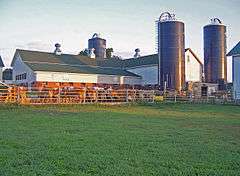 |
(#78000105) |
N of Fort Atkinson 42°56′48″N 88°50′12″W / 42.946667°N 88.836667°W |
Fort Atkinson | |
| 22 | Arthur R. Hoard House | 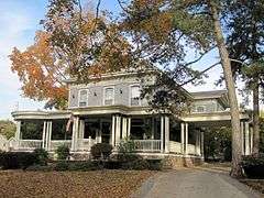 |
(#82001845) |
323 Merchants Ave. 42°55′28″N 88°50′07″W / 42.924444°N 88.835278°W |
Fort Atkinson | |
| 23 | Jefferson Fire Station | 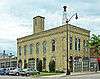 |
(#84000695) |
146 E. Milwaukee St. 43°00′15″N 88°48′22″W / 43.004167°N 88.806111°W |
Jefferson | Alexander Kirkland and Adam Spangler, Italianate style |
| 24 | Jefferson High School | 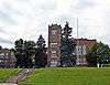 |
(#00001643) |
201 S. Copeland Ave. 43°00′15″N 88°48′45″W / 43.004167°N 88.8125°W |
Jefferson | Gothic revival style |
| 25 | Jefferson Public Library | 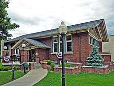 |
(#80000142) |
305 S. Main St. 43°00′12″N 88°48′27″W / 43.003333°N 88.8075°W |
Jefferson | Claude and Starck, Prairie School style |
| 26 | Jones Dairy Farm | 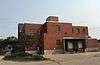 |
(#78000107) |
Jones Ave. 42°55′22″N 88°50′45″W / 42.922778°N 88.845833°W |
Fort Atkinson | |
| 27 | Main Street Commercial Historic District | 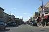 |
(#89000483) |
Roughly Main St. from N. Washington St. to S. Seventh St. 43°11′40″N 88°43′23″W / 43.194444°N 88.723056°W |
Watertown | |
| 28 | Main Street Commercial Historic District |  |
(#97001627) |
Roughly bounded by Dodge St., Center Ave., Mechanic St., and Rock R. 43°00′17″N 88°48′26″W / 43.004722°N 88.807222°W |
Jefferson | |
| 29 | Main Street Historic District | _side.JPG) |
(#84003683) |
Roughly Main St. from Sherman Ave. to S. 3rd St. 42°55′41″N 88°50′15″W / 42.928056°N 88.8375°W |
Fort Atkinson | |
| 30 | Eli May House | 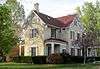 |
(#72000056) |
407 E. Milwaukee Ave. 42°55′37″N 88°49′52″W / 42.926944°N 88.831111°W |
Fort Atkinson | |
| 31 | Monroe McKenzie House | 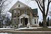 |
(#85001360) |
226 Main St. 42°52′38″N 88°35′10″W / 42.877222°N 88.586111°W |
Palmyra | |
| 32 | Merchants Avenue Historic District | 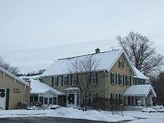 |
(#86001303) |
Roughly bounded by S. Third St. E and S. Milwaukee Ave. E, Foster St., Whitewater, and Merchant Aves. 42°55′27″N 88°50′06″W / 42.924167°N 88.835°W |
Fort Atkinson | |
| 33 | North Washington Street Historic District |  |
(#09000850) |
N. Church St. generally bounded by O'Connell and N. Green St., N. Washington St. bounded by O'Connell and Elm Sts. 43°11′51″N 88°43′44″W / 43.197369°N 88.728864°W |
Watertown | |
| 34 | Octagon House | 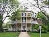 |
(#71000039) |
919 Charles St. 43°11′05″N 88°42′27″W / 43.184722°N 88.7075°W |
Watertown | |
| 35 | Panther Intaglio Effigy Mound | |
(#70000035) |
Address Restricted |
Fort Atkinson | |
| 36 | Pioneer Aztalan Site | |
(#75000069) |
SE corner at jct. of SR B and Sr Q 43°04′19″N 88°51′38″W / 43.071944°N 88.860556°W |
Aztalan | at Aztalan State Park |
| 37 | Pitzner Site (47 Je 676) | |
(#82000676) |
Address Restricted |
Jefferson | |
| 38 | Puerner Block-Breunig's Brewery | 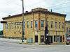 |
(#84003687) |
101-115 E. Racine, 110-112 N. Main St. 43°00′18″N 88°49′09″W / 43.005°N 88.819167°W |
Jefferson | Italianate style |
| 39 | Richards Hill Residential Historic District |  |
(#13000403) |
Roughly bounded by Western, Richards, Thomas & Harvey Aves., Livsey Pl. & Charles St. Coordinates missing |
Watertown | |
| 40 | Saint Bernard's Church Complex | 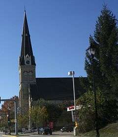 |
(#03001221) |
100 and 108 S. Church St. and 111 S. Montgomery St. 43°11′39″N 88°43′44″W / 43.194167°N 88.728889°W |
Watertown | |
| 41 | Albert and Mary Shekey House | 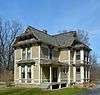 |
(#15000404) |
W7526 Koshkonong Mounds Rd. 42°52′33″N 88°54′21″W / 42.875758°N 88.905744°W |
Koshkonong | |
| 42 | Richard C. Smith House | 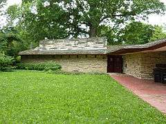 |
(#79000338) |
332 E. Linden St. 43°00′08″N 88°48′07″W / 43.002222°N 88.801944°W |
Jefferson | Frank Lloyd Wright, 1950 |
| 43 | Albert F. Solliday House | 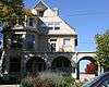 |
(#03001249) |
114 S. Church St. 43°11′38″N 88°43′44″W / 43.193889°N 88.728889°W |
Watertown | |
| 44 | South Washington Street Historic District |  |
(#03001220) |
Odd numbered 201-309 S. Church St. and S. Washington St. from Emmet St. to West St. 43°11′30″N 88°43′41″W / 43.191667°N 88.728056°W |
Watertown | |
| 45 | St. Paul's Episcopal Church |  |
(#79000087) |
413 S 2nd St. 43°11′29″N 88°43′24″W / 43.191389°N 88.723333°W |
Watertown | |
| 46 | St. Wenceslaus Roman Catholic Church |  |
(#75000070) |
SE of Waterloo at jct. of Blue Point and Island Rds. 43°09′40″N 88°55′16″W / 43.161111°N 88.921111°W |
Waterloo | |
| 47 | Telfer Site | |
(#00000316) |
Address Restricted |
Milford | |
| 48 | Waterloo Downtown Historic District |  |
(#00001360) |
Jct. of Madison and Monroe Sts. 43°11′02″N 88°59′25″W / 43.183889°N 88.990278°W |
Waterloo |
See also
| Wikimedia Commons has media related to National Register of Historic Places in Jefferson County, Wisconsin. |
- List of National Historic Landmarks in Wisconsin
- National Register of Historic Places listings in Wisconsin
References
- ↑ The latitude and longitude information provided is primarily from the National Register Information System, and has been found to be fairly accurate for about 99% of listings. For 1%, the location info may be way off. We seek to correct the coordinate information wherever it is found to be erroneous. Please leave a note in the Discussion page for this article if you believe any specific location is incorrect.
- ↑ "National Register of Historic Places: Weekly List Actions". National Park Service, United States Department of the Interior. Retrieved on December 2, 2016.
- ↑ Numbers represent an ordering by significant words. Various colorings, defined here, differentiate National Historic Landmarks and historic districts from other NRHP buildings, structures, sites or objects.
- ↑ The eight-digit number below each date is the number assigned to each location in the National Register Information System database, which can be viewed by clicking the number.
- ↑ Barry Adams (June 26, 2011). "On Wisconsin: After 3-year hiatus, historic Waterloo merry-go-round bounces back". Wisconsin State Journal. Retrieved April 2, 2013.
| Topics | |
|---|---|
| Lists by states |
|
| Lists by insular areas | |
| Lists by associated states | |
| Other areas | |
| |
Municipalities and communities of Jefferson County, Wisconsin, United States | ||
|---|---|---|
| Cities | | |
| Villages | ||
| Towns | ||
| CDPs | ||
| Unincorporated communities |
| |
| Footnotes | ‡This populated place also has portions in an adjacent county or counties | |
This article is issued from Wikipedia - version of the 5/15/2016. The text is available under the Creative Commons Attribution/Share Alike but additional terms may apply for the media files.