| [3] |
Name on the Register[4] |
Image |
Date listed[5] |
Location |
City or town |
Description |
|---|
| 1 |
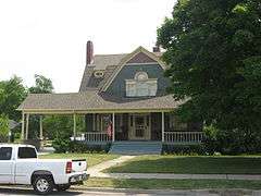
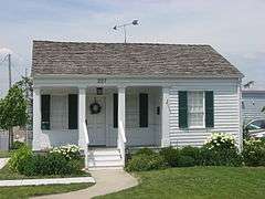
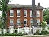
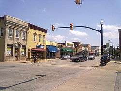
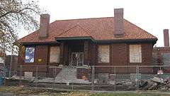
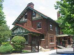
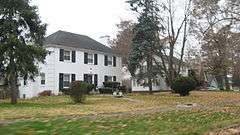
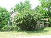
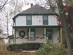
Walter Allman House |
|
000000002010-12-27-0000December 27, 2010
(#10001077) |
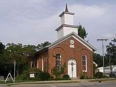
102 S. East St.
41°25′04″N 87°21′43″W / 41.417778°N 87.362078°W / 41.417778; -87.362078 (Walter Allman House) |
Crown Point |
|
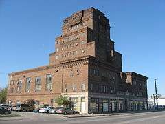
| 2 |
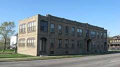
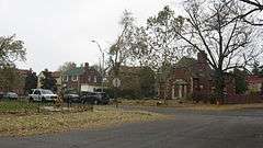
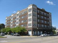
American Sheet and Tin Mill Apartment Building |
|
000000002009-06-17-0000June 17, 2009
(#09000427) |
633 W. 4th Ave.
41°36′13″N 87°20′44″W / 41.603611°N 87.345556°W / 41.603611; -87.345556 (American Sheet and Tin Mill Apartment Building) |
Gary |
|
| 3 |
Louis J. Bailey Branch Library-Gary International Institute |
|
000000002004-09-29-0000September 29, 2004
(#04001102) |
1501 S. Madison St.
41°35′16″N 87°20′29″W / 41.587778°N 87.341389°W / 41.587778; -87.341389 (Louis J. Bailey Branch Library-Gary International Institute) |
Gary |
|
| 4 |
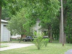
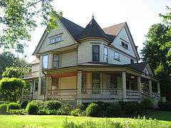
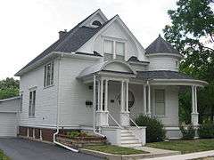
James Brannon House |
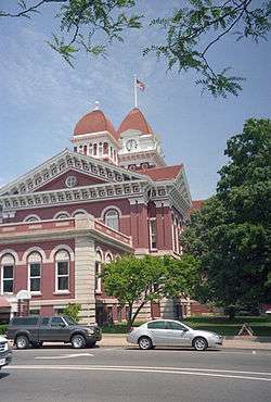
|
000000002011-03-21-0000March 21, 2011
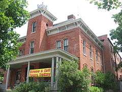
(#11000120) |
260 Burnham St.
41°17′42″N 87°24′53″W / 41.295000°N 87.414722°W / 41.295000; -87.414722 (James Brannon House) |
Lowell |
|
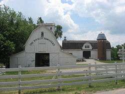
| 5 |
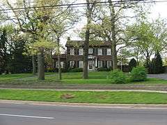
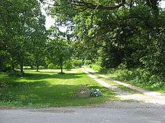
Buckley Homestead |
|
000000001984-12-06-0000December 6, 1984
(#84000503) |
3606 Belshaw Rd., southeast of Lowell
41°16′53″N 87°22′43″W / 41.281389°N 87.378611°W / 41.281389; -87.378611 (Buckley Homestead) |
Cedar Creek Township |
|
| 6 |
Wellington A. Clark House |
|
000000002001-06-06-0000June 6, 2001
(#01000619) |
227 S. Court St.
41°24′57″N 87°21′57″W / 41.415722°N 87.365833°W / 41.415722; -87.365833 (Wellington A. Clark House) |
Crown Point |
|
| 7 |
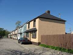
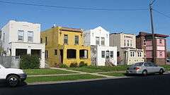
Combs Addition Historic District |
|
000000002014-09-30-0000September 30, 2014
(#14000805) |
400 and 500 blocks of Rutledge and Ellsworth Sts., and the 500 block of Marshall St. between 4th and 6th Aves.
41°36′10″N 87°22′10″W / 41.602778°N 87.369444°W / 41.602778; -87.369444 (Combs Addition Historic District) |
Gary |
|
| 8 |
Crawford-Winslow House |
|
000000002013-06-25-0000June 25, 2013
(#13000422) |
357 S. Main St.
41°24′47″N 87°21′53″W / 41.413194°N 87.364722°W / 41.413194; -87.364722 (Crawford-Winslow House) |
Crown Point |
|
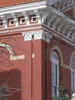
| 9 |
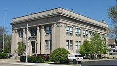
Crown Point Courthouse Square Historic District |
|
000000002004-03-22-0000March 22, 2004
(#04000203) |
Roughly bounded by Clark St., the alley east of Main St., Hack Ct., and Court St.; also roughly bounded by Robinson, East, Walnut, and Court Sts.; also 208 Main St.
41°25′02″N 87°21′56″W / 41.417333°N 87.365456°W / 41.417333; -87.365456 (Crown Point Courthouse Square Historic District) |
Crown Point |
Second set of boundaries represents a boundary adjustment of 000000002005-12-08-0000December 8, 2005; 208 Main represents a boundary increase of 000000002007-03-29-0000March 29, 2007
|
| 10 |
Morse Dell Plain House and Garden |
|
000000001998-04-01-0000April 1, 1998
(#98000298) |
7109 Knickerbocker Parkway
41°35′03″N 87°28′39″W / 41.584167°N 87.4775°W / 41.584167; -87.4775 (Morse Dell Plain House and Garden) |
Hammond |
|
| 11 |
Ralph Waldo Emerson School |
|
000000001995-06-09-0000June 9, 1995
(#95000702) |
716 E. 7th Ave.
41°35′57″N 87°19′39″W / 41.599167°N 87.3275°W / 41.599167; -87.3275 (Ralph Waldo Emerson School) |
Gary |
|
| 12 |
Eskilson Historic District |
|
000000002014-03-26-0000March 26, 2014
(#14000073) |
Roughly bounded by W. 3rd Ave. and the alleys between Garfield and Hayes Sts., W. 4th Pl., and W. 5th Ave., Cleveland St., and McKinley St.
41°36′13″N 87°21′37″W / 41.603611°N 87.360278°W / 41.603611; -87.360278 (Eskilson Historic District) |
Gary |
|
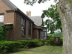
| 13 |
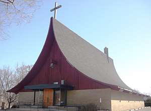
First Unitarian Church of Hobart |
|
000000001999-09-09-0000September 9, 1999
(#99001112) |
497 Main St.
41°31′48″N 87°15′11″W / 41.530000°N 87.253056°W / 41.530000; -87.253056 (First Unitarian Church of Hobart) |
Hobart |
|
| 14 |
Forest-Ivanhoe Residential Historic District |
|
000000002010-03-31-0000March 31, 2010
(#10000124) |
Roughly bounded by 172nd Pl., the eastern side of Forest Ave. south to its end, and the Little Calumet River
41°34′51″N 87°31′25″W / 41.580931°N 87.523533°W / 41.580931; -87.523533 (Forest-Ivanhoe Residential Historic District) |
Hammond |
|
| 15 |
Forest-Moraine Residential Historic District |
|
000000002010-09-23-0000September 23, 2010
(#10000777) |
Roughly bounded by Wildwood Rd., 165th St., Hohman Ave. and State Line Ave.
41°35′53″N 87°31′24″W / 41.598056°N 87.523333°W / 41.598056; -87.523333 (Forest-Moraine Residential Historic District) |
Hammond |
|
| 16 |
Forest-Southview Residential Historic District |
|
000000002010-09-23-0000September 23, 2010
(#10000778) |
Roughly bounded by 165th St., Hohman Ave., Locust St. and State Line Ave.
41°35′37″N 87°31′25″W / 41.593611°N 87.523611°W / 41.593611; -87.523611 (Forest-Southview Residential Historic District) |
Hammond |
|
| 17 |
Gary Bathing Beach Aquatorium |
|
000000001994-11-25-0000November 25, 1994
(#94001354) |
One Marquette Dr., Marquette Park
41°37′11″N 87°15′24″W / 41.619722°N 87.256667°W / 41.619722; -87.256667 (Gary Bathing Beach Aquatorium) |
Gary |
|
| 18 |
Gary City Center Historic District |
|
000000001994-11-25-0000November 25, 1994
(#94001352) |
Roughly Broadway from the Chicago SouthShore and South Bend railroad tracks to 9th Ave.
41°36′01″N 87°20′13″W / 41.600278°N 87.336944°W / 41.600278; -87.336944 (Gary City Center Historic District) |
Gary |
|
| 19 |
Gary Land Company Building |
|
000000001979-05-08-0000May 8, 1979
(#79000021) |
4th Ave. and Massachusetts St.
41°36′15″N 87°20′09″W / 41.604167°N 87.335833°W / 41.604167; -87.335833 (Gary Land Company Building) |
Gary |
|
| 20 |
Gary Public Schools Memorial Auditorium |
|
000000001994-11-25-0000November 25, 1994
(#94001353) |
700-734 Massachusetts St.
41°35′53″N 87°20′10″W / 41.598056°N 87.336111°W / 41.598056; -87.336111 (Gary Public Schools Memorial Auditorium) |
Gary |
|
| 21 |
Glendale Park Historic District |
|
000000002013-06-25-0000June 25, 2013
(#13000423) |
17-64 Glendale Parkway
41°36′07″N 87°31′24″W / 41.601944°N 87.523333°W / 41.601944; -87.523333 (Glendale Park Historic District) |
Hammond |
|
| 22 |
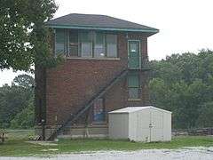
E.J. and E. Griffith Interlocking Tower |
|
000000002003-09-28-0000September 28, 2003
(#03000980) |
201 S. Broad St.
41°31′16″N 87°25′39″W / 41.521111°N 87.4275°W / 41.521111; -87.4275 (E.J. and E. Griffith Interlocking Tower) |
Griffith |
|
| 23 |
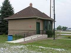
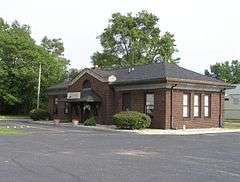
Griffith Grand Trunk Depot |
|
000000002003-09-28-0000September 28, 2003
(#03000985) |
201 S. Broad St.
41°31′16″N 87°25′39″W / 41.521111°N 87.4275°W / 41.521111; -87.4275 (Griffith Grand Trunk Depot) |
Griffith |
|
| 24 |
Melvin A. Halsted House |
|
000000001978-12-08-0000December 8, 1978
(#78000037) |
201 E. Main St.
41°17′36″N 87°25′21″W / 41.293333°N 87.422389°W / 41.293333; -87.422389 (Melvin A. Halsted House) |
Lowell |
|
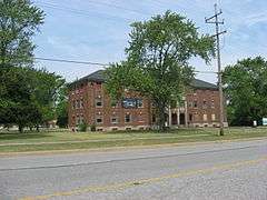
| 25 |
Hobart Carnegie Library |
|
000000001982-07-15-0000July 15, 1982
(#82000047) |
706 E. 4th St.
41°31′55″N 87°15′07″W / 41.532083°N 87.251944°W / 41.532083; -87.251944 (Hobart Carnegie Library) |
Hobart |
|
| 26 |
Hobart Commercial District |
|
000000002014-12-16-0000December 16, 2014
(#14001037) |
Roughly bounded by Lake George, the Norfolk Southern rail line, and Center and 2nd Sts..
41°31′55″N 87°15′17″W / 41.531944°N 87.254722°W / 41.531944; -87.254722 (Hobart Commercial District) |
Hobart |
|
| 27 |
Hohman Avenue Commercial Historic District |
|
000000002011-03-21-0000March 21, 2011
(#11000118) |
Approximately three blocks lining Hohman Ave. between Clinton St. and Rimbach St.
41°37′02″N 87°31′19″W / 41.617222°N 87.521944°W / 41.617222; -87.521944 (Hohman Avenue Commercial Historic District) |
Hammond |
|
| 28 |
Hoosier Theater Building |
|
000000001987-02-18-0000February 18, 1987
(#87000069) |
1329-1335 119th St.
41°40′46″N 87°29′47″W / 41.679444°N 87.496389°W / 41.679444; -87.496389 (Hoosier Theater Building) |
Whiting |
|
| 29 |
Ibach House |
|
000000002010-12-27-0000December 27, 2010
(#10001078) |
1908 Ridge Rd.
41°33′26″N 87°28′56″W / 41.557222°N 87.482222°W / 41.557222; -87.482222 (Ibach House) |
Munster |
|
| 30 |
Indi-Illi Park Historic District |
|
000000002012-06-15-0000June 15, 2012
(#12000335) |
Roughly bounded by Locust and 169th Sts., and Hohman and State Line Aves.
41°35′24″N 87°31′28″W / 41.590000°N 87.524444°W / 41.590000; -87.524444 (Indi-Illi Park Historic District) |
Hammond |
|
| 31 |
Indiana Harbor Public Library |
|
000000002005-09-15-0000September 15, 2005
(#05001014) |
3605 Grand Ave.
41°38′51″N 87°26′58″W / 41.647500°N 87.449444°W / 41.647500; -87.449444 (Indiana Harbor Public Library) |
East Chicago |
|
| 32 |
Jackson-Monroe Terraces Historic District |
|
000000002009-06-17-0000June 17, 2009
(#09000428) |
404-423 Jackson St. and 408-426 Monroe St.
41°36′12″N 87°20′39″W / 41.603333°N 87.344167°W / 41.603333; -87.344167 (Jackson-Monroe Terraces Historic District) |
Gary |
|
| 33 |
Jefferson Street Historic District |
|
000000002013-09-18-0000September 18, 2013
(#13000723) |
Roughly bounded by Washington St. and 37th, 35th, Jefferson, and Madison Aves.
41°33′10″N 87°20′21″W / 41.552778°N 87.339167°W / 41.552778; -87.339167 (Jefferson Street Historic District) |
Gary |
|
| 34 |
Francis P. Keilman House |
|
000000002013-03-20-0000March 20, 2013
(#13000084) |
9260 Patterson St.
41°27′03″N 87°28′17″W / 41.450750°N 87.471389°W / 41.450750; -87.471389 (Francis P. Keilman House) |
St. John |
|
| 35 |
Kingsbury-Doak Farmhouse |
|
000000002005-09-15-0000September 15, 2005
(#05001013) |
4411 E. 153rd Ave., west of Hebron
41°20′20″N 87°17′11″W / 41.338889°N 87.286389°W / 41.338889; -87.286389 (Kingsbury-Doak Farmhouse) |
Eagle Creek Township |
|
| 36 |
Knights of Columbus Building |
|
000000001984-03-01-0000March 1, 1984
(#84001065) |
333 W. 5th Ave.
41°36′06″N 87°20′30″W / 41.601667°N 87.341667°W / 41.601667; -87.341667 (Knights of Columbus Building) |
Gary |
|
| 37 |
Lake County Courthouse |
|
000000001973-05-17-0000May 17, 1973
(#73000073) |
Public Sq.
41°25′02″N 87°21′57″W / 41.417222°N 87.365833°W / 41.417222; -87.365833 (Lake County Courthouse) |
Crown Point |
|
| 38 |
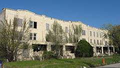
Lake County Tuberculosis Sanatorium, Nurses Home and Superintendent's House |
|
000000002005-06-17-0000June 17, 2005
(#05000608) |
2323 N. Main St. and 425 W. 93rd Ave.
41°27′04″N 87°21′55″W / 41.451111°N 87.365278°W / 41.451111; -87.365278 (Lake County Tuberculosis Sanatorium, Nurses Home and Superintendent's House) |
Crown Point |
427 W. 93rd represents a boundary increase of 000000002013-01-09-0000January 9, 2013
|
| 39 |
Lake County Sheriff's House and Jail |
|
000000001989-01-04-0000January 4, 1989
(#88003039) |
232 S. Main St.
41°24′56″N 87°21′51″W / 41.415556°N 87.364167°W / 41.415556; -87.364167 (Lake County Sheriff's House and Jail) |
Crown Point |
|
| 40 |
Lassen Hotel |
|
000000001981-07-07-0000July 7, 1981
(#81000019) |
7808 W. 138th Pl.
41°22′06″N 87°25′30″W / 41.368333°N 87.425°W / 41.368333; -87.425 (Lassen Hotel) |
Cedar Lake |
|
| 41 |
Lincoln Street Historic District |
|
000000002013-12-31-0000December 31, 2013
(#13001012) |
Roughly bounded by Fillmore and Hayes Sts. and 6th and 8th Aves.
41°35′57″N 87°21′17″W / 41.599167°N 87.354722°W / 41.599167; -87.354722 (Lincoln Street Historic District) |
Gary |
|
| 42 |
Lowell Commercial Historic District |
|
000000002003-03-26-0000March 26, 2003
(#03000144) |
305-519 Commercial Ave. and 108-110 Clark St.
41°17′30″N 87°25′23″W / 41.291667°N 87.423056°W / 41.291667; -87.423056 (Lowell Commercial Historic District) |
Lowell |
|
| 43 |
Albert Maack House |
|
000000002011-06-23-0000June 23, 2011
(#11000383) |
498 S. Court St.
41°24′34″N 87°21′58″W / 41.409444°N 87.366111°W / 41.409444; -87.366111 (Albert Maack House) |
Crown Point |
|
| 44 |
Horace Mann Historic District |
|
000000002013-09-18-0000September 18, 2013
(#13000722) |
Roughly bounded by W. 5th, 8th, and 7th Aves., and Cleveland and Roosevelt Sts.
41°36′00″N 87°21′47″W / 41.600000°N 87.363056°W / 41.600000; -87.363056 (Horace Mann Historic District) |
Gary |
|
| 45 |
Marktown Historic District |
|
000000001975-02-20-0000February 20, 1975
(#75000025) |
Bounded by Pine, Riley, Dickey, and 129th Sts.
41°39′31″N 87°28′04″W / 41.658611°N 87.467778°W / 41.658611; -87.467778 (Marktown Historic District) |
East Chicago |
|
| 46 |
MATERIAL SERVICE (shipwreck) |
|
000000002014-03-25-0000March 25, 2014
(#14000074) |
Lake Michigan, northeast of Calumet Harbor[6]
41°44′33″N 87°30′23″W / 41.742500°N 87.506389°W / 41.742500; -87.506389 (MATERIAL SERVICE (shipwreck)) |
North Township |
|
| 47 |
Joseph Ernest Meyer House |
|
000000001984-03-01-0000March 1, 1984
(#84001068) |
1370 Joliet St.
41°29′26″N 87°29′48″W / 41.490556°N 87.496667°W / 41.490556; -87.496667 (Joseph Ernest Meyer House) |
Dyer |
|
| 48 |
Miller Town Hall |
|
000000001978-07-07-0000July 7, 1978
(#78000038) |
Junction of Miller Ave., Old Hobart Rd., and Grand Boulevard
41°36′02″N 87°15′41″W / 41.600556°N 87.261389°W / 41.600556; -87.261389 (Miller Town Hall) |
Gary |
|
| 49 |
Monon Park Dancing Pavilion |
|
000000002001-01-03-0000January 3, 2001
(#00001540) |
13701 Lauerman St.
41°22′07″N 87°26′22″W / 41.368611°N 87.439444°W / 41.368611; -87.439444 (Monon Park Dancing Pavilion) |
Cedar Lake |
|
| 50 |
Monroe Terrace Historic District |
|
000000002009-06-17-0000June 17, 2009
(#09000429) |
304-318 Monroe St.
41°36′19″N 87°20′37″W / 41.605278°N 87.343611°W / 41.605278; -87.343611 (Monroe Terrace Historic District) |
Gary |
|
| 51 |
Morgan-Skinner-Boyd Homestead |
|
000000002010-12-27-0000December 27, 2010
(#10001079) |
111 E. 73rd Ave.
41°29′08″N 87°20′02″W / 41.485556°N 87.333889°W / 41.485556; -87.333889 (Morgan-Skinner-Boyd Homestead) |
Merrillville |
|
| 52 |
Morningside Historic District |
|
000000002009-09-24-0000September 24, 2009
(#09000758) |
Roughly bounded by the eastern side of Washington, the western side of Jefferson, and 45th and 47th Sts.
41°32′05″N 87°20′22″W / 41.534722°N 87.339444°W / 41.534722; -87.339444 (Morningside Historic District) |
Gary |
|
| 53 |
Charles E. Nichols House |
|
000000002010-06-24-0000June 24, 2010
(#10000375) |
231 W. Commercial Ave.
41°17′23″N 87°25′39″W / 41.289722°N 87.427444°W / 41.289722; -87.427444 (Charles E. Nichols House) |
Lowell |
|
| 54 |
Northern States Life Insurance Company |
|
000000002010-06-24-0000June 24, 2010
(#10000376) |
5935 Hohman Ave.
41°36′20″N 87°31′18″W / 41.605556°N 87.521667°W / 41.605556; -87.521667 (Northern States Life Insurance Company) |
Hammond |
|
| 55 |
Pennsylvania Railroad Station |
|
000000001984-03-01-0000March 1, 1984
(#84001070) |
1001 Lillian St.
41°32′04″N 87°14′50″W / 41.534444°N 87.247222°W / 41.534444; -87.247222 (Pennsylvania Railroad Station) |
Hobart |
|
| 56 |
Polk Street Concrete Cottage Historic District |
|
000000002011-09-15-0000September 15, 2011
(#11000657) |
604-614 Polk St.
41°35′59″N 87°21′00″W / 41.599722°N 87.350000°W / 41.599722; -87.350000 (Polk Street Concrete Cottage Historic District) |
Gary |
|
| 57 |
Polk Street Terraces Historic District |
|
000000002009-06-17-0000June 17, 2009
(#09000430) |
404-422 and 437-455 Polk St.
41°36′13″N 87°20′59″W / 41.603611°N 87.349722°W / 41.603611; -87.349722 (Polk Street Terraces Historic District) |
Gary |
|
| 58 |
Pullman-Standard Historic District |
|
000000002012-04-10-0000April 10, 2012
(#12000186) |
Roughly bounded by Columbia, Field, Porter, and Willard Aves.
41°36′17″N 87°29′53″W / 41.604637°N 87.498134°W / 41.604637; -87.498134 (Pullman-Standard Historic District) |
Hammond |
|
| 59 |
Theodore Roosevelt High School |
|
000000002012-12-19-0000December 19, 2012
(#12001059) |
730 W. 25th St.
41°34′28″N 87°20′42″W / 41.574444°N 87.345000°W / 41.574444; -87.345000 (Theodore Roosevelt High School) |
Gary |
|
| 60 |
Roselawn-Forest Heights Historic District |
|
000000002012-12-19-0000December 19, 2012
(#12001060) |
Roughly bounded by Lawndale, 172nd Pl., and Hohman and State Line Aves.
41°35′12″N 87°31′26″W / 41.586667°N 87.523889°W / 41.586667; -87.523889 (Roselawn-Forest Heights Historic District) |
Hammond |
|
| 61 |
John Ross Farm |
|
000000001996-03-27-0000March 27, 1996
(#96000283) |
3815 E. U.S. Route 231, northwest of Leroy
41°22′14″N 87°17′21″W / 41.370556°N 87.289167°W / 41.370556; -87.289167 (John Ross Farm) |
Winfield Township |
|
| 62 |
J. Claude Rumsey House |
|
000000002008-12-22-0000December 22, 2008
(#08001211) |
709 Michigan Ave.
41°17′44″N 87°25′00″W / 41.295556°N 87.416667°W / 41.295556; -87.416667 (J. Claude Rumsey House) |
Lowell |
|
| 63 |
Barney Sablotny House |
|
000000002012-12-19-0000December 19, 2012
(#12001061) |
501 W. 47th St.
41°31′59″N 87°20′33″W / 41.532917°N 87.342500°W / 41.532917; -87.342500 (Barney Sablotny House) |
Gary |
|
| 64 |
St. Augustine's Episcopal Church |
|
000000002013-09-18-0000September 18, 2013
(#13000758) |
2425 W. 19th Ave.
41°35′03″N 87°22′05″W / 41.584167°N 87.368056°W / 41.584167; -87.368056 (St. Augustine's Episcopal Church) |
Gary |
|
| 65 |
Southmoor Apartment Hotel |
|
000000002011-03-21-0000March 21, 2011
(#11000125) |
5946 Hohman Ave.
41°36′19″N 87°31′20″W / 41.605278°N 87.522222°W / 41.605278; -87.522222 (Southmoor Apartment Hotel) |
Hammond |
|
| 66 |
Stallbohm Barn-Kaske House |
|
000000001998-04-01-0000April 1, 1998
(#98000303) |
1154 Ridge Rd.
41°33′35″N 87°30′01″W / 41.559722°N 87.500278°W / 41.559722; -87.500278 (Stallbohm Barn-Kaske House) |
Munster |
|
| 67 |
State Bank of Hammond Building |
|
000000001984-09-27-0000September 27, 1984
(#84001072) |
5444-5446 Calumet Ave.
41°36′51″N 87°30′33″W / 41.614250°N 87.509167°W / 41.614250; -87.509167 (State Bank of Hammond Building) |
Hammond |
|
| 68 |
State Street Commercial Historic District |
|
000000001999-09-17-0000September 17, 1999
(#99001157) |
Roughly State St. between Sohl and Bulletin Ave.
41°37′07″N 87°31′00″W / 41.618611°N 87.516667°W / 41.618611; -87.516667 (State Street Commercial Historic District) |
Hammond |
|
| 69 |
Van Buren Terrace Historic District |
|
000000002007-06-22-0000June 22, 2007
(#07000565) |
336-354 Van Buren St.
41°36′17″N 87°20′47″W / 41.604722°N 87.346389°W / 41.604722; -87.346389 (Van Buren Terrace Historic District) |
Gary |
|
| 70 |
West Fifth Avenue Apartments Historic District |
|
000000001984-05-17-0000May 17, 1984
(#84001076) |
Roughly 5th Ave. from Taft to Pierce St.
41°36′06″N 87°21′29″W / 41.601667°N 87.358056°W / 41.601667; -87.358056 (West Fifth Avenue Apartments Historic District) |
Gary |
|
| 71 |
William Whitaker Landscape and House |
|
000000001999-09-09-0000September 9, 1999
(#99001107) |
472 S. Main St.
41°24′37″N 87°21′50″W / 41.410278°N 87.363889°W / 41.410278; -87.363889 (William Whitaker Landscape and House) |
Crown Point |
|
| 72 |
Whiting Memorial Community House |
|
000000001980-02-08-0000February 8, 1980
(#80000044) |
1938 Clark St.
41°40′41″N 87°29′47″W / 41.678056°N 87.496389°W / 41.678056; -87.496389 (Whiting Memorial Community House) |
Whiting |
|
| 73 |
George John Wolf House |
|
000000002007-06-21-0000June 21, 2007
(#07000563) |
7220 Forest Ave.
41°34′57″N 87°31′27″W / 41.582500°N 87.524167°W / 41.582500; -87.524167 (George John Wolf House) |
Hammond |
|
| 74 |
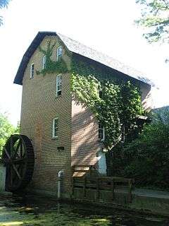
John Wood Old Mill |
|
000000001975-10-10-0000October 10, 1975
(#75000026) |
East of central Merrillville on State Road 330
41°28′36″N 87°13′18″W / 41.476528°N 87.221667°W / 41.476528; -87.221667 (John Wood Old Mill) |
Merrillville |
|